Winter Service Plan 2022 – 2023
- Introduction
- Policy statement
- Client/consultant/contractor relationship
- Decision making
- Rostering of supervisory and operational staff
- Road hierarchy
- Footways and cycleways
- Salting operation and salt
- Snow clearance
- Grit bins
- Plant and vehicles
- Operational communications
- Weather forecasts
- Thermal mapping and ice prediction
- Media communications
- List of appendices
- Appendix A: Primary and secondary salting routes
- Appendix B: Guidance notes for Duty Officers
- Appendix C: Call out guidelines
- Appendix D: Sample decision sheet
- Appendix E: Footways – snow clearing/pre-salting
- Appendix F: Call out facilities
- Appendix G: Grit bin locations
- Appendix H: Location of structures to receive ‘double pre-salt’ salting
- Appendix I: Winter service cross boundary arrangements
- Appendix J: Plan showing salting network, salting routes and location of grit bins
- Appendix K: Circulation list
- Appendix L: References
1. Introduction
1.1 This document has been produced in association with the documents “Well Maintained Highways” Code of Practice for Highway Maintenance (Published July 2005, revised 2009, 2010 & 2011) and “Lessons learned from the severe weather February 2009” report (revised 2010 & 2011), ‘Quarmby Report’ December 2010 and the ‘Well-managed Highway Infrastructure – Code of Practice’ October 2016, to describe the Council’s proposals for dealing with ice/snow deposits on the highway network over the winter period. It details information regarding the winter service, such as the roles and responsibilities of Reading Borough Council and the joint arrangement with Wokingham Borough Council, its Consultant Volker Highways (Wokingham Highways Alliance) and Winter Maintenance Contractor J H Cresswell and Sons Ltd.
1.2 Roads forming the Primary and Secondary precautionary salting networks are shown in Appendix A. These are the most heavily used strategic roads in the Borough, including the main bus routes and routes to the Royal Berkshire Hospital.
1.3 A winter service will be provided by the Council for 26 weeks of the year, starting on 1st October 2022 and ending on 31st March 2023. The formal winter service with Wokingham Borough Council and their Consultant, Volker Highways, commences on the 1st November 2022. However, as agreed at the pre-winter season meeting, Volker Highways provides an informal weather data monitoring service from the 1st October 2022. Should salting action be required during October, Reading Borough Council will be advised and the Winter Maintenance Contractor, J H Cresswell and Sons Ltd, will be instructed accordingly. Although the formal winter service ends on 31st March 2023, a similar arrangement will be in place to extend the weather data monitoring service to the end of April 2023 if unfavourable conditions persist.
1.4 Precautionary salting of the Primary network (refer to 1.12) and snow clearance on the Primary routes will be carried out based on information received from the weather forecasting service. The Secondary precautionary salting network (refer to 1.13) will only be salted and/or cleared of snow during particularly severe and prolonged hazardous winter weather conditions. The decision to instigate such action will be taken by the Winter Duty Officer based on information received from the weather forecasting service at the time. The primary precautionary salting network is risk assessed and comprises of principal roads, including main bus routes and routes to the Royal Berkshire Hospital. Likewise, the secondary precautionary salting network is risk assessed and comprises of the remaining bus route network and roads linking strategic routes.
1.5 Where the Council has been made aware of water being deposited on the highway as the result of an unforeseen incident, for example fire, road traffic accident, burst water main etc, salt shall be applied, during freezing conditions, to reduce as far as possible the effects of frost, ice and other severe winter weather conditions on the highway.
1.6 Where water is being deposited on the highway from a water main and Thames Water is aware of the problem, they will begin to salt the area affected until the issue has been resolved. Thames Water will continue to salt any visible leaks of their own plant whether or not the leak is on a Council salting network. Thames Water provides the Council with a list of known leak sites to be salted by their own contractor.
1.7 Spreading of a proprietary material/grit/salt on Town Centre footways, as detailed in Appendix E, will be carried out based on forecast information received from the weather forecasting service at the time. The decision to spread a proprietary material/grit/salt in the town centre is made and carried out by the Council.
1.8 For Primary and Secondary precautionary salting routes, response and treatment times are 1 hour and 3 hours respectively. This means that the Contractor must commence salting within 1 hour of receiving the winter gritting decision/ instruction and complete all of the salting routes within 3 hours of leaving their depot.
1.9 As the Highway Authority, Reading Borough Council has a legal duty under Section 41 (Clause 1A) and Section 150 of the Highways Act 1980 to remove accumulations of snow, if causing a highway to become obstructed. Roads will therefore be cleared of snow in descending order of priority commencing with the First Priority network as described in Section 9 of this document.
1.10 In accordance with the recommendations of the “Lessons learned from the Severe Weather February 2009” report, the Council has introduced a Contingency Salting Network to cover the prolonged periods and heavy accumulations of snow and national salt shortages as described in 6.8.
1.11 Salt spread rates, where possible, will be adjusted to meet the directives set out as described in the “Quarmby Audit” report and adopted by Highways Authorities in December 2010.
1.12 The Primary precautionary salting network is approximately 118.8 km in length, represents approximately 30% of the total road network and comprises principal roads, including main bus routes and routes to the Royal Berkshire Hospital.
1.13 The Secondary precautionary salting network is approximately 42.02 km, represents approximately 11% of the total road network and is comprised of, the remaining bus route network and roads linking strategic routes.
1.14 There are currently 47 grit bins provided at locations throughout the Borough for public use. The grit bins are maintained by the Contractor and are detailed in Appendix G. The provision of grit bins on the Borough’s public highway network has been reviewed and risk assessed. A grit bin has to achieve a minimum score of 60 points, using the Council’s approved grit bin risk assessment pro-forma, to qualify. 47 grit bins continue to meet this criteria. The grit bins are repaired and replenished throughout the winter period as necessary. At the end of the winter, all grit bins are collected, cleaned and stored away during the summer months.
1.15 All cross-boundary primary and secondary precautionary salting routes correspond with neighbouring authorities precautionary salting routes, refer to paragraph 6.7.
1.16 The treatment of the M4 motorway and the on/off 4 slip roads at Junction 11 is the responsibility of Highways England and their agent. The Junction 11/A33 gyratory, A33 carriageway and bus lanes within the Borough boundary are included within the Council’s Primary Salting Network.
2. Policy statement
Reading Borough Council aim to provide a winter maintenance service to reduce so far as is reasonably practicable the effects of frost, ice and snow and other severe winter conditions on the public highway. The Council aim to provide travelling conditions as safe as reasonably practicable having regard to the road hierarchy detailed in Section 6 of this document, ‘Well-managed Highway Infrastructure – Code of Practice’ October 2016, as well as the Highways Act 1980 Section 41 (Clause 1A) and Section 150.
3. Client/consultant/contractor relationship
3.1 The Winter Maintenance Contract (2022/23-2027/28) specifies the Winter Service operations to be carried out within the Borough. The term contractor is J. H. Cresswell and Sons Ltd.
3.2 Innovative ideas proposed by the Client, Consultant, Contractor or DfT that provide improvements in quality of service and/or cost benefits will be adopted during the course of the winter season. An example would be adjusting salt spread rates during prolonged cold periods to maximise coverage and maintain adequate stock levels.
3.3 The following table indicates how the principal Winter Service responsibilities between Reading Borough Council, Wokingham Borough Council and its Consultant and the Contractor are split.
| Activity | Responsibility |
|---|---|
| Preparation of Winter Service Plan | Reading Borough Council |
| Road hierarchy priorities | Reading Borough Council |
| Salt purchase and storage | Contractor: JH Cresswell and Sons Ltd |
| Route mapping for precautionary salting network | Contractor: JH Cresswell and Sons Ltd |
| Route mapping for snow clearance | Reading Borough Council/ Contractor: JH Cresswell and Sons Ltd |
| Vehicles/plant and accreditation | Owned and routinely maintained by contractor |
| Winger Service Manager/decision making | Wokingham Borough Council (Volker Highways) |
| Day to day operations | Mainly contractor: JH Cresswell and Sons Ltd with central co-ordination by Reading Borough Council/Wokingham Borough Council (Volker Highways) staff |
| Manning levels | As defined in the Winter Maintenance Contract (2022/23-2027/28) |
| Performance monitoring | Wokingham Borough Council (Volker Highways) /Reading Borough Council |
| Opening of Emergency Operations Centre and Emergency Planning Room | Reading Borough Council |
| Approval to commence operations in extreme snow conditions | Reading Borough Council |
| Weather forecasting service | MeteoGroup/Vaisala |
3.4 The Contractor will provide the Council with a list of any wet spots identified during each salting run, for the Council to investigate further. The Contractor will also provide the Council with a list of roads that have not been salted and the reason why e.g. road works/traffic management.
4. Decision making
4.1 Decision making is the responsibility of the Consultant’s (Volker Highways) appropriate Duty Officer (except in the cases detailed in paragraphs 4.11 and 4.12). Each 24 hour period, during the winter service period, the Duty Officer will be on standby.
The Duty Officer also has a specific responsibility for liaising directly with the MeteoGroup duty forecaster and for disseminating information as described in Section 15.
4.2 The Duty Officer is responsible for receiving and taking the appropriate action on information relating to the winter service within the Borough. Using the forecast data provided, the Duty Officer will make his/her decision regarding precautionary salting as appropriate. To assist with this process, call out guidance notes are as detailed in Appendices B and C. The Winter Service Manager will also be available to give advice to the Duty Officer when required.
4.3 At approximately midday the Duty Officer logs on to MeteoGroup web page and inspects the rolling 36 hour forecast, graphs and appropriate maps. It is likely that the decision will be made at this time. If it is not possible to make a decision at midday the contractor is advised at this time that he is to wait for a decision following the evening update.
4.4 At approximately 1800 hours the Duty Officer logs on to MeteoGroup web page and inspects the forecast graph and text for any updated information. The forecast graph continues to have actual road surface temperatures plotted every hour for a rolling 36 hour period. This information can be obtained at any time by the Duty Officer by logging on to the web page. If a decision still cannot be made it may be necessary for the Duty Officer to consult the weather forecaster.
4.5 It is the responsibility of each Duty Officer to record all action taken on the justification forms and file for future reference.
4.6 The Duty Officer’s decision is recorded on a decision sheet as shown in Appendix D, which is disseminated and filed for future reference.
4.7 When snow is forecast the snow clearance strategy is to be controlled by the Council in consultation with Volker Highways. In times of prolonged severe weather staff from the Council will liaise directly with the contractor in order to direct operations in the most effective way possible.
4.8 The Contractor is contacted via email and mobile phones, which are manned 24 hours per day. The daily decision sheets are emailed to the contractor by Volker Highways to confirm the instruction.
4.9 The daily decision sheets are provided by Volker Highways to the Council, electronically. The decisions are also disseminated within the council and placed on the appropriate social media platform to inform the public.
4.10 Appropriate training is provided regularly for all Duty Officers, particularly with regard to technological improvements in forecasting techniques and the ice prediction system.
4.11 Where one of the emergency services contacts the Council requesting a one off gritting following either a road traffic accident, a fire resulting in localised excess water or a water leak, Streetcare Services will instruct during normal working hours or, if out of hours, The Answering Service (TAS) will instruct accordingly.
4.12 The Town Centre footway/pavement areas, listed in Appendix E, are treated by the Council’s Streetcare Services. The decision whether to treat these is taken by Streetcare Services as outlined in Section 7.
5. Rostering of supervisory and operational staff
5.1 Wokingham Borough Council has employed Volker Highways to act as Highways and Transportation Consultant’s whose role is to act as the Winter Service Manager. As part of the above agreement Reading Borough Council have a joint arrangement for Volker Highways to provide a winter decision making service.
5.2 The Consultant’s team of Duty Officers is rostered to be on standby for the winter period, which is generally November to March inclusive. However, as agreed at the pre-winter season meeting, Volker Highways will be providing an informal weather data monitoring service/Duty Officer standby arrangement from the 1st October 2022 with a similar arrangement in place extended through to the end of April 2023 if unfavourable weather conditions persist.
5.3 A Winter Service Duty Officer is available 24 hours a day, during his/her week on duty. During normal office hours all Winter Service enquiries from members of the public should be directed to the Streetcare Services – Highways Maintenance & Asset Management Team at Reading Borough Council, disseminated, and where the policy applies, information forwarded onto the Consultant’s (Volker Highways).
5.4 Outside normal office hours, enquiries should be directed to the call out facility listed in Appendix F. (Officers’ home telephone numbers will not be released to members of the public).
5.5 To continually improve the service, all public requests for salting and grit bins will be logged by the Council and forwarded to the Streetcare Services – Highways Maintenance & Asset Management Team for assessment at the end of the winter season. Only in circumstances where emergency services make a request for salting will the Council’s Winter Maintenance Contractor be mobilised before an assessment is completed. Further information concerning weather forecasts and the decision making process are provided in Sections 4 and 13.
5.6 Rosters of all of the Contractor’s staff involved in winter service operations are requested by 1st October 2021.
5.7 All operators of salt spreading equipment are in possession of The City and Guilds Institute (scheme 6159) ‘Winter Maintenance Operators Qualification’ and all gritting plant conforms to current TRL Quality Assurance certification and accreditation. The Winter Maintenance Contractor provides the gritting vehicle calibration certificates to the Council in advance of the winter season.
5.8 Prior to the commencement of the winter period, each Duty Officer is provided with an information pack, which includes details of all appropriate telephone contacts, together with any additional information that may be appropriate.
6. Road hierarchy
6.1 The Primary precautionary salting network comprises all Category 1 and Category 2 roads and some heavily trafficked Category 3 roads which are defined as follows:
-
-
Category 1: The most important roads in the Borough in terms of volume of traffic carried, the proportion of heavy goods vehicles and their strategic function as principal links.
-
Category 2: The main distributor roads carrying significant volumes of traffic and public transport services. These are important thoroughfares distributing traffic from the strategic routes to residential and commercial areas.
-
Category 3: All other roads being roads providing local access within and between residential and commercial areas.
-
The total length of the Council’s Primary Salting Network is approximately 118.8 km which represents approximately 30% of the highway network (excluding the motorway) within the Borough area.
6.2 The Secondary precautionary salting network is approximately 42.02 km in length and represents approximately 11% of the highway network. It is comprised of the remaining bus route network and roads linking strategic routes, which become hazardous if left untreated during prolonged periods of particularly severe weather conditions.
6.3 The Primary precautionary salting network is broken down into 3 individual salting routes. Each route is efficiently designed in order to comply with the maximum treatment time of 3 hours. In the event of the Snow Plan being activated the Primary precautionary salting network is broken down into 4 individual salting routes. The Primary precautionary salting routes to be treated by the Contractor are detailed in Appendix A.
6.4 The Secondary precautionary salting network is broken down into 4 salting routes. The Secondary salting routes to be treated by the Contractor are detailed in Appendix A.
6.5 The snow clearance routes comprise of 3 priority groups.
-
- First – All of the Category 1 network which are all the A Class roads in the Borough.
- Second – All of the Category 2 network which includes all of the B Class roads and some of the heavier trafficked C Class roads.
- Third – The remaining C class roads.
- First – All of the Category 1 network which are all the A Class roads in the Borough.
Snow clearance shall commence with the ‘first priority’ network and only when this has been cleared shall resources cascade to the ‘second priority’ followed by the ‘third priority’ networks.
Roads will therefore be cleared of snow in descending order of priority until such time as the ‘first priority’ network is clear. Only when this is clear shall resources cascade to the ‘second priority’ followed by the ‘third priority’ networks (see Section 9).
6.6 Performance of the Contractor in relation to response and treatment times is monitored to ensure satisfactory service delivery and contract compliance, where appropriate.
6.7 By agreement no cross Borough boundary salting and snow clearance will take place between Reading Borough Council and adjoining Unitary Authorities or vice versa, (refer to Appendix I).
6.8 In accordance with the recommendations of the “Lessons learned from the Severe Weather February 2009” report, the Council will introduce a Contingency Salting Network to cover any prolonged periods and heavy accumulations of snow and national salt shortages. The length of network to be treated will be determined based on the Council’s salt stocks, the national salt stock situation and the anticipated period of severe weather.
6.9 The “Quarmby report” from 2010 gives guidance on efficient spread rates for preserving salt stocks. This is used when determining the rate at which salt is spread over the public highway during different weather conditions and salt levels.
6.10 The treatment of the M4 motorway and the on/off entry and exit slip roads at Junction 11 is the responsibility of the Highways England and their agent. The M4 Junction 11/A33 gyratory, A33 carriageway and bus lanes within the Borough boundary are included within the Council’s Primary Salting Network.
7. Footways and cycleways
7.1 The Council does not precautionary salt any of its footway network, however if snow is predicted to lay for a prolonged period then the town centre area, as detailed in Appendix E, will be treated with a proprietary material/grit/salt to prevent snow and ice forming. The footways listed in Appendix E are treated with a proprietary material/grit/salt as they have a high pedestrian footfall.
7.2 The decision to treat the footways listed in Appendix E is taken by the Council’s Streetcare Services. This work is also directly carried out by Streetcare Services.
7.3 Streetcare Services usually require approximately 3 hours notice to prepare the equipment, product and staff for the works. Once the spreading of a proprietary material/grit/salt has started it takes approximately 1.5 hours to cover the route.
7.4 The Council has 2 hand operated snow ploughs which will be deployed on town centre footways, over Reading and Caversham Bridges and over the Christchurch Bridge, in the event of heavy accumulations of snow. On completion of these locations a decision will be made on cascading down to other high footfall areas based on a dynamic risk assessment reflecting conditions prevailing at the time.
7.5 Cyclists can continue to cycle in winter but are advised to dress appropriately, use mudguards and lights, consider tyres (the wider the better) and commuting by bike can be comfortable and efficient. It is important to make a safety assessment particularly during periods of prolonged hazardous conditions, (refer to Council’s Snow Plan). The Council does not precautionary grit / salt shared footways and remote cycleways when frost, ice or prolonged hazardous conditions are forecast, with the exception of shared carriageway / cycleway routes on the primary and secondary salting network. Being part of the carriageway, shared carriageway/cycleway routes on the primary and secondary precautionary salting route networks will be salted by default in accordance with the Winter Service Plan.
Should individuals make the decision to cycle during hazardous winter conditions the Council recommend that they take the necessary precautionary measures for the prevailing conditions.
8. Salting operations and salt
Response time
8.1 Throughout the winter service period the Contractor must start salting within 1 hour of receiving the instruction from the Duty Officer or at the time specified.
8.2 Each primary precautionary salting route is designed so that treatment can be completed in a maximum of 3 hours from the time of leaving the depot.
8.3 Salt complying with BS3247 shall be supplied by the Contractor and stored at Aldermaston. It is a contractual requirement that appropriate salt stockpiles are in place by 1st October each year.
| Date/quantity | 1 October (100%) | 31 December (100%) | 28 February (100%) | 31 March (66%) |
| Salt total | 900 tonnes | 900 tonnes | 900 tonnes | 600 tonnes |
8.4 All of the salt stock is stored in the open at Aldermaston, covered by proprietary sheeting.
8.5 Salt shall normally be applied in accordance with the “Quarmby Report” unless there are severe prolonged periods of snow or low national salt stocks. In such situations an appropriate spread rate will be implemented by the Contractor as agreed by the Council in consultation with the Consultant, Volker Highways, the Contractor and the salt supplier.
8.6 Bridge decks are given a double precautionary salting as the surface temperatures get much colder than those of regular roads. The bridges that are given a double precautionary salt are listed in Appendix H.
Motorways
8.7 The treatment of the M4 motorway and the on/off slip roads at Junction 11 is the responsibility of the Highways England and their agent. The M4 Junction 11/A33 gyratory, A33 carriageway and bus lanes within the Borough boundary are included within the Council’s Primary Salting Network.
9. Snow clearance
9.1 When conditions are such that snow clearance becomes necessary, an instruction will be given by the Duty Officer to the Contractor to commence the snow clearance operation. It is essential that snow ploughs are fitted without delay.
9.2 During prolonged severe weather when snow clearance becomes necessary, the Emergency Planning Officer will implement the Council’s Snow Plan and open the Emergency Operations Centre (EOC) which will be staffed until conditions abate. During this time, all incoming calls relating to winter service operations will be directed by the EOC. Responsibility for instructing the Contractor will be passed from Volker Highways Duty Officer to the appropriate Council Officer.
9.3 The Council provides snow clearance routes for the Contractor to treat in accordance with the procedures outlined in the Snow Plan. The highway (carriageway) network is cleared in descending order of priority, concentrating on the clearance of the first priority network followed by other priority networks in accordance with the agreed policy. Certain highway (footway) areas in the town centre that are block paved will be treated using a proprietary material/grit/salt, these are shown in Appendix E.
The snow clearance route priorities are:
- First – A33, A329 (including IDR), A4, A4074, A4155, A327
- Second – B3270, B480, B3031
- Third – All other remaining roads.
9.4 Following snow clearance operations, the routes will be inspected for damage. Details of the damage will be passed to Streetcare Services for preparation of estimates and damage repair.
9.5 In the case of prolonged periods and heavy accumulations of snow and/or a national salt shortage, the Council will implement a Contingency Salting Network. The network will be designed to deliver a risk based contingency service in line with the UK Road Groups Report “Lessons from the Severe Weather February 2009” report and new Code of Practice.
Motorways
9.6 The treatment of the M4 motorway and the on/off slip roads at Junction 11 is the responsibility of the Highways England and their agent. The M4 Junction 11/A33 gyratory, A33 carriageway and bus lanes within the Borough boundary are included within the Council’s Primary Salting Network.
10. Grit bins
10.1 Grit bins are provided on the Borough’s public highway network but only where they have achieved a minimum score of 60 out of a total of 85 points as previously assessed, using the grit bin risk assessment pro-forma (Appendix G refers). The grit bins are repaired and replenished throughout the winter period as necessary. At the end of the winter, all grit bins are collected, cleaned and stored away during the summer months.
Grit bin requests are evaluated on a risk based scoring system using the following criteria:
- Not on roads already on the gritting network or nearby grit bin
- Gradient greater than 10%
- Severe bends not including junctions
- Close proximity to and falling towards a heavily trafficked main road
- Number of premises for which the road is only access
- Traffic density at peak times
- Roads with high vehicle usage and a gradient of 10% or more
- Shaded carriageways with a minimum gradient of 10%
- Side road leading onto a main road
- Known problem with water and/or frost hollows
- Access available from carriageway for filling
(To qualify, a grit bin requires a minimum score of 60 out of a total of 85 points).
10.2 Requested locations for grit bins on the public highway will be reviewed and evaluated on an annual basis before the start of the winter season. Any new requests will be required to achieve a minimum score of 60 out of a total of 85 points to qualify. (Grit bin locations which have been assessed previously will not be reassessed).
10.3 For non-public highway areas, stakeholders and other Council Directorates/Teams are advised to purchase their own grit bins and salt stocks, as well as to make their own arrangements to spread the salt, prior to the winter season. Stakeholders and Council Directorates/Teams can choose to contact Streetcare Services for a quote to supply grit bin(s) and/or salt. The stakeholder / Council Directorate/Team will need to make their own arrangements for salt spreading as appropriate.
10.4 The Council will support community groups & individuals who express an interest to fund the installation of additional grit bins and take on the maintenance liability by way of an appropriate Highway Licence.
It should be noted that Streetcare services and its Winter Maintenance Contractor/Consultant will give priority to delivering the winter service for the Borough’s public highway network.
11. Plant and vehicles
11.1 The Council’s Winter Maintenance Contractor owns and maintains all the equipment used for Winter Service operations with the exception of the footway ploughs and proprietary material hand-spreaders (Refer to 11.8).
11.2 Prior to the operational winter service period the Contractor will carry out a ‘dry’ run of each precautionary salting route, attach/remove snow ploughs to/from each vehicle and carry out calibration test to the equipment.
11.3 To be effective, salt must be spread evenly and at rates to suit prevailing weather conditions. Excessive salt spreading is undesirable on both environmental and economic grounds. To this end, it is essential that the spreading equipment is calibrated annually in accordance with BS 1622 and the controls marked accordingly for spreads of 8g/m2 for normal pre-salting and 11g/m2, 15g/m2 20g/m2 and 40g/m2 for more severe conditions in line with recommendations outlined in the Quarmby Report Dec 2020.
11.4 All winter service vehicle drivers are issued with mobile ‘phones for communication.
11.5 All of the Contractor’s staff are qualified to City and Guilds Local Government Management Board 6157 now superseded by City and Guilds 6159 for salting and snow clearance operations.
11.6 Details of all routes including maps are kept in each vehicle.
11.7 A small, towable salt spreader is used on narrow roads where the larger winter service vehicles cannot manoeuvre or travel along due to road widths, parked vehicles etc.
11.8 The Council own two hand operated footway snow ploughs and several proprietary material hand-spreaders to reduce the effects and lower the risk of snow and ice accumulations in the Town Centre block-paved areas (refer to Appendix E).
12. Operational communications
12.1 All winter service vehicle drivers are in contact with the Contractor’s depot via mobile phones in order that instructions can be passed and current information relayed back directly from the vehicles.
12.2 The Contractor is required to provide the Council with a list of the contact details that are to be used by 1st October 2022.
12.3 The Contractor is required to provide the Council with a copy of the Daily Winter Service Action report after each salting run. This records details of each vehicle, driver, route number, start time, finish time, rate of spread and any other remarks.
12.4 In emergency situations when mobile ‘phone networks are not available, the Council and Volker Highways have the use of airwave radios for communication purposes.
13. Weather forecasts
During the winter period, the Council will use the ‘Roadmaster’ forecasting service provided by MeteoGroup, from their UK HQ in Victoria, London. The information received each day includes the following:
(i) detailed rolling 36 hour forecast
(ii) evening update forecast
(iii) site specific temperature graphs (three sites)
(iv) early morning summary and preliminary forecast
(v) 2 – 10 day forecast
The 36 hour forecast is received at approximately midday each day. The main features of this forecast are as follows:
(i) Readiness Colour
This is based on the traffic light system of colours; green, amber or red. The definitions are:
-
- Green – No hazard expected.
- Amber – RSTs below zero but road dry
- Amber – RST between 0 and +1C (inclusive)
- Amber – RST > +1C and < +2C with low confidence Red
- Red – RSTs below zero with a hazard.
(ii) Hazards
This section includes the hazards causing the red or amber readiness colours as well as other weather hazards such as heavy rain, high winds or fog, which could accompany a green readiness colour. A qualifying time will be given for all hazards.
(iii) Minimum temperatures
Minimum air and road temperatures for urban and rural areas are provided.
(iv) Confidence statements
This consists of high, moderate or low confidence for each of the hazards described above, together with a qualifying statement. For example: low confidence regarding extent of showers this evening but high regarding road temperatures falling below zero.
(v) 36 hour weather summary
This is a general summary of the forecast for a rolling 36 hour period.
At approximately 1800 hours each evening, a forecast update is issued by MeteoGroup and can be viewed by the Duty Officer at home on a portable laptop computer. “If further information is required, the Duty Officer can make use of the 24 hour consultancy service provided by MeteoGroup – 0845 603 0563”
14. Thermal mapping and ice prediction
Reading roads
14.1 Vaisala Ltd has undertaken thermal mapping across Berkshire, a technique for measuring and analysing the thermal characteristics of road surfaces. It is normally carried out under three different weather conditions, one of which is the extreme condition or night when skies are clear and winds light. The other weather conditions are known as intermediate and damped. Under extreme conditions, the maximum variation in road surface temperature is produced, this, together with the coldest absolute temperatures, leads to potentially hazardous road conditions. Under such conditions it is most important to be able to accurately predict road surface temperatures.
14.2 The information yielded from thermal mapping is used in conjunction with site specific forecasts to predict accurately the minimum temperature of road surfaces across the road network. This allows accurate decisions to be made not only about whether to salt or not but whether to salt only those roads that require treatment.
14.3 Thermal mapping has been used to produce data, which allows the pre-salting routes to be analysed objectively and to ensure the optimum location of road surface and atmospheric condition sensors.
14.4 Annual calibration checks on sensors are undertaken by the equipment supplier(s).
14.5 Every hour, information from these sensors is fed automatically into the Central Processing Unit at Vaisala’s offices in Birmingham. The parameters recorded are, air temperature, humidity, precipitation, wind speed and direction, road surface condition (wet or dry) and depth temperature. Forecasts are produced by MeteoGroup based on this information. These forecasts when used in conjunction with the thermal mapping data forms one of the most sophisticated ice prediction systems in the U.K.
14.6 West Berkshire Council acts as lead authority on behalf of the other Berkshire Unitary Authorities in respect of the co-ordination and procurement of contracts with Vaisala and MeteoGroup Ltd. The formulation of this alliance between the authorities is known as the Berkshire Consortium.
14.7 All six members of the Berkshire Consortium (consisting of the six Unitary Local Authorities within the former Berkshire County Council administrative area) have access to the ice detection equipment described above.
14.8 The Berkshire Consortium own weather stations situated within Berkshire and have a contract with Vaisala Ltd. Once the data is in a usable format it is passed on to MeteoGroup who will make the weather predictions. The nearest weather station for Reading is on the A329 Oxford Road (located outside Battle Library).
15. Media communications
15.1 Liaison with the news media, particularly the local radio stations, The Breeze, BBC Radio Berkshire and Heart FM is of the utmost importance and will be maintained during periods of severe snowfall. This is to notify the public of any driving advice or road closures etc that will affect their journeys or safety. This contact will normally be directly with the Council’s Press Office who will be fed information from Streetcare Services.
15.2 It is also desirable that communications with the local Police force is maintained. To this end, whenever an instruction to salt is issued by Volker Highways, a copy of the decision sheet will be emailed to the Thames Valley Police Headquarters at Kidlington who will then distribute the notification accordingly. Additional information will also be provided as appropriate to the motoring organisations during periods of snow clearance when it is essential that the travelling public are advised of current road conditions and cleared routes.
15.3 Information on winter gritting / salting and guidance on safer driving this winter on Reading roads together with a plan showing the roads that will be treated is published on the Council’s website.
15.4 Information on the current policy and precautionary salting plans is available on the Council’s website.
15.5
- The ‘Winter Service Plan 2022/2023’ Committee Report, presented to the Housing Neighbourhoods and Leisure Committee, is available on the Council’s website. This Report includes details on the review process carried out following the 2021/2022 winter season and updates to this Winter Service Plan for the 2022/2023 winter season.
Appendix A
Summary of roads on primary and secondary precautionary salting network
Table 1 – Council’s primary salting network
| Road name | Section |
|---|---|
| A33 | ALL – INC MRT BUS LANES / BYPASS – SOUTH OAK WAY R/BOUT |
| ALEXANDRA ROAD | PART – UPPER REDLANDS ROAD TO ADDINGTON ROAD |
| ADDINGTON ROAD | PART – REDLANDS ROAD TO CRAVEN ROAD |
| B3270 | ALL |
| BAGNALL WAY | ALL |
| BASINGSTOKE ROAD | ALL |
| BATH ROAD | ALL |
| BEDFORD ROAD | PART – OXFORD ROAD TO CHATHAM STREET |
| BERESFORD ROAD | ALL |
| BERKELEY AVENUE | ALL |
| BLAGRAVE STREET | ALL |
| BRIANTS AVENUE | ALL |
| BRIDGE STREET, CAVERSHAM | ALL |
| BRIDGE STREET, READING | ALL |
| BUCKINGHAM DRIVE | ALL |
| BURGHFIELD ROAD | ALL |
| CASTLE HILL | ALL |
| CASTLE STREET | ALL |
| CAVERSHAM PARK ROAD | ALL |
| CAVERSHAM ROAD | ALL |
| CHAPEL HILL | ALL |
| CHATHAM STREET | ALL |
| CHEAPSIDE | ALL |
| CHRISTCHURCH GARDENS | PART – NORTHUMBERLAND AVENUE TO BASINGSTOKE ROAD |
| CHRISTCHURCH ROAD | ALL |
| CHURCH ROAD, CAVERSHAM | ALL |
| CHURCH STREET, CAVERSHAM | ALL |
| CITY ROAD | ALL |
| CORWEN ROAD | ALL |
| COW LANE | ALL |
| CRAVEN ROAD | ALL |
| CRESSINGHAM ROAD | ALL |
| CROWN STREET | ALL |
| DEE ROAD | ALL |
| DONKIN HILL | ALL |
| DUKE STREET | ALL |
| DWYER ROAD | ALL |
| ELDON ROAD | ALL |
| ELM ROAD | ALL |
| EVESHAM ROAD | PART – SOUTHDOWN ROAD TO BUCKINGHAM DRIVE |
| FORBURY ROAD | ALL |
| FRIAR STREET | ALL |
| GEORGE STREET, CAVERSHAM | ALL |
| GILLETTE WAY | ALL |
| GOSBROOK ROAD | PART – PROSPECT STREET TO BRIANTS AVENUE |
| GREAT KNOLLYS STREET | PART – CAVERSHAM ROAD TO NORTH STREET |
| GREYFRIARS ROAD | ALL |
| GROVELANDS ROAD | ALL |
| GUN STREET GWEAL AVENUE | ALL ALL |
| HARTLAND ROAD | ALL |
| HEMDEAN ROAD | PART – CHURCH STREET TO OAKLEY ROAD |
| HENLEY ROAD | ALL |
| HIGH STREET | ALL |
| HILDENS DRIVE | ALL |
| HOLYBROOK ROAD | ALL |
| HONEY END LANE | ALL |
| IDR INNER RELIEF ROAD | ALL |
| KENDRICK ROAD | ALL |
| KENTWOOD HILL | ALL |
| KING STREET | ALL |
| KING’S ROAD, READING | ALL |
| LIEBENROOD ROAD LINDISFARNE WAY | ALL ALL |
| LONDON ROAD | ALL |
| LONDON STREET | ALL |
| LOWER ELMSTONE DRIVE | ALL |
| LOWER HENLEY ROAD LOWFIELD ROAD | ALL ALL |
| MANOR FARM ROAD | PART – GWEAL AVE TO GILLETTE WAY |
| MARKET PLACE MAYFAIR | ALL ALL |
| MILL LANE | ALL |
| MINSTER STREET | ALL |
| MOUNT PLEASANT | ALL |
| NORCOT ROAD | ALL |
| NORTH STREET, READING | ALL |
| NORTHERN WAY | ALL |
| NORTHUMBERLAND AVENUE | ALL |
| OVERDOWN ROAD | ALL |
| OXFORD ROAD | ALL |
| PARK LANE | ALL |
| PELL STREET | ALL |
| PEPPARD ROAD | EXCLUDING LOOP LOWFIELD ROAD TO BUCKINGHAM DRIVE |
| PEPPER LANE | ALL |
| PIERCES HILL | ALL |
| PORTMAN ROAD | ALL |
| PRIEST HILL | ALL |
| PROSPECT STREET, CAVERSHAM | ALL |
| QUEEN’S ROAD, READING | ALL |
| READING BRIDGE | ALL |
| REDLANDS ROAD | ALL |
| RICHFIELD AVENUE | ALL |
| ROSE KILN LANE | ALL |
| ROTHERFIELD WAY | ALL |
| SOUTHDOWN ROAD | PART – ROTHERFIELD WAY TO EVESHAM ROAD |
| RUSSELL STREET | ALL |
| SCHOOL ROAD | ALL |
| SHEPHERDS LANE | PART – UPPER WOODCOTE ROAD TO WOODCOTE WAY |
| SHINFIELD ROAD | ALL |
| SIDMOUTH STREET | PART – LONDON ROAD TO QUEEN’S ROAD |
| SILVER STREET | ALL |
| SOUTHAMPTON STREET | ALL |
| SOUTHCOTE LANE | ALL |
| ST MARYS BUTTS | ALL |
| ST PETERS HILL | ALL |
| ST SAVIOURS ROAD | PART – BERKELEY AVENUE TO HOLYBROOK ROAD |
| STANSHAWE ROAD | ALL |
| STATION HILL | ALL |
| STATION ROAD | ALL |
| THE FORBURY | PART – VALPY STREET TO MARKET PLACE |
| THE MEADWAY | ALL |
| THE TRIANGLE | PART – ST MICHAELS ROAD TO WALNUT WAY |
| TILEHURST ROAD | ALL |
| TROOPER POTTS WAY | ALL |
| TUDOR ROAD | ALL |
| UPPER WOODCOTE ROAD | ALL |
| VALPY STREET | ALL |
| VASTERN ROAD | ALL |
| WATER ROAD | ALL |
| WATLINGTON STREET | PART – QUEEN’S ROAD TO KING’S ROAD |
| WELDALE STREET | PART – CAVERSHAM ROAD TO NORTH STREET |
| WENSLEY ROAD | PART – HOLYBROOK ROAD TO HOSPITAL ROUNDABOUT |
| WEST STREET | ALL |
| WHITLEY STREET | ALL |
| WHITLEY WOOD LANE | ALL |
| WHITLEY WOOD ROAD | ALL |
| WIGMORE LANE | ALL |
| WOKINGHAM ROAD | ALL |
| WOODCOTE ROAD | ALL |
| WOODCOTE WAY | ALL |
Table 2 – Council’s secondary salting network
| Road name | Section |
|---|---|
| ACRE ROAD | ALL |
| ADDINGTON ROAD | PART – CRAVEN ROAD TO ERLEIGH ROAD |
| ALBERT ROAD | ALL |
| ALL HALLOWS ROAD | ALL |
| ALPINE STREET | ALL |
| AMERSHAM ROAD | ALL |
| ARMOUR HILL | ALL |
| ARMOUR ROAD | ALL |
| ASHAMPTSTEAD ROAD | ALL |
| BEECH ROAD | ALL |
| BENNET ROAD | ALL |
| BERKSHIRE DRIVE | ALL |
| BLAGDON ROAD | ALL |
| BLENHEIM ROAD (CAVERSHAM) | ALL |
| BUCKLAND ROAD | ALL |
| CHURCH END LANE | ALL |
| CIRCUIT LANE | PART – SOUTHCOTE LANE TO SILCHEATER ROAD |
| COCKNEY HILL | ALL |
| CONISBORO AVENUE | PART – ALBERT ROAD TO UPLANDS ROAD |
| CONNAUGHT ROAD | PART – TILEHURST ROAD TO PRINCE OF WALES AVENUE |
| CORBRIDGE ROAD | ALL |
| COURTENAY DRIVE | ALL |
| CRANBURY ROAD | PART – TILEHURST ROAD TO PRINCE OF WALES AVENUE |
| CRESCENT ROAD | ALL |
| EASTERN AVENUE | PART – CRESCENT ROAD TO WHITEKNIGHTS ROAD |
| ELGAR ROAD | ALL |
| ELGAR ROAD SOUTH | ALL |
| ELMHURST ROAD | ALL |
| ELMHURST DRIVE | ALL |
| ERLEIGH ROAD | ALL |
| EVESHAM ROAD | PART – SOUTHDOWN ROAD TO GROVE ROAD |
| GOSBROOK ROAD | PART – BRIANTS AVENUE TO STAR LANE |
| GROVE ROAD | ALL |
| HEXHAM ROAD | PART – NORTHUMBERLAND AVENUE TO CORBRIDGE ROAD |
| HIGHMOOR ROAD | PART – ALBERT ROAD TO WOODCOTE ROAD |
| HOGARTH AVENUE | ALL |
| HUNTERS CHASE | ALL |
| IMPERIAL WAY | ALL |
| ISLAND ROAD | ALL |
| KENAVON DRIVE | ALL |
| KENSINGTON ROAD | PART – TILEHURST ROAD TO PRINCE OF WALES AVENUE |
| KIDMORE END ROAD | ALL |
| KIDMORE ROAD | ALL |
| KILN ROAD | PART – CAVERSHAM PARK ROAD TO MARCHWOOD AVENUE |
| KINGS MEADOW ROAD | PART – VASTERN ROAD TO NAPIER ROAD |
| LINDEN ROAD | ALL |
| MICKLANDS ROAD | ALL |
| NEW LANE HILL | PART – HOGARTH AVENUE TO THE MEADWAY |
| NAPIER ROAD | ALL |
| NEWCASTLE ROAD | PART – NORTHUMBERLAND AVENUE TO CORBRIDGE ROAD |
| NORTHBROOK ROAD | ALL |
| OAKLEY ROAD | ALL |
| OAK TREE ROAD | ALL |
| OLD HONEY END LANE | ALL |
| PROSPECT STREET, READING | ALL |
| RICHMOND ROAD (CAVERSHAM) | ALL |
| SHEPHERDS LANE | PART – WOODCOTE WAY TO KIDMORE ROAD |
| SILCHESTER ROAD | PART – CIRCUIT LANE TO FAIRCROSS ROAD |
| SPEY ROAD | ALL |
| ST. ANNE’S ROAD | ALL |
| ST. MICHAEL’S ROAD | ALL |
| STAR ROAD | ALL |
| SURLEY ROW | PART – ROTHERFIELD WAY TO ST. BARNABAS ROAD |
| SWALLOWFIELD DRIVE | ALL |
| TAY ROAD | PART – DEE ROAD TO SPEY ROAD |
| TREDEGAR ROAD | ALL |
| THE MOUNT, CAVERSHAM | PART – ALBERT ROAD TO PRIEST HILL |
| UPLANDS ROAD | ALL |
| USK ROAD | ALL |
| WAVERLEY ROAD | ALL |
| WENSLEY ROAD | PART – HOSPITAL ROUNDABOUT TO END/LOOP |
| WESTERN ELMS AVENUE | ALL |
| WESTWOOD ROAD | ALL |
| WESTWOOD GLEN | ALL |
| WHITEKNIGHTS ROAD | ALL |
| WILSON ROAD | ALL |
| WOLSELEY STREET | ALL |
Appendix B
Guidance notes for Duty Officers
1. Forecast information
- At approximately midday log on to MeteoGroup web page and inspect rolling 36 hour forecast, graphs and appropriate maps. It is likely that your decision will be made at this time. If it is not possible to make a decision at midday the contractor must be advised at this time that he is to wait for a decision following the evening update.
- At approximately 1800 hours log on to MeteoGroup web page and inspect forecast graph and text for any updated information. The forecast graph will continue to have actual road surface temperatures plotted every hour for a rolling 36 hour period. This information can be obtained at any time by logging on to the web page. If a decision still cannot be made it may be necessary to consult the weather forecaster.
- It is the responsibility of each Duty Officer to record all action taken on the justification forms and file for future reference.
2. Communications
- If the Duty Officer needs to communicate with the Duty Manager then contact should initially be made by mobile phone.
- The Duty Officer and the Duty Manager should keep each other aware of their movements if they are likely to be unable answer the mobile phone for any length of time.
- The Duty Officer will also be responsible for sending a fax/email message to the Police, local radio stations and neighbouring authorities informing them of the decision made concerning precautionary salting.
3. Role of the Duty Manager
The Duty Manager will be available to give advice to the Duty Officer when required.
Appendix C
Winter service call out guidelines
| Forecase road conditions | Forecast weather |
|---|---|
| 1. Road surface dry | A. Road surface temperature (RST) above freezing (i) +4°C or above (ii) above 0°C, below +4°C |
| Wet patches due to seepage etc | B. RST at or below 0°C (i) 0°C to -3°C |
| Road surface wet but may dry | (ii) below -3°C |
| Road surface wet | C. B(i) or B(ii) with rain beforehand |
| Road surface dry but may become wet | D. Hoar frost E. Freezing fog F. Freezing rain G. Snow (i) light falls up to 30mm (ii) falls over 30mm |
No precautionary salting if:
- Road surface temperature is above 4 degrees Celsius
- Road surface temperature is between -3 and 4 degrees Celsius and road surface is dry
Partial salt (wet patches, major structures, high ground) if:
- Road surface temperature is between 0 and 4 degrees Celsius and road is dry
- Road surface temperature is between -3 and 4 degrees Celsius and road has wet patches
- Road surface temperature is between 0 and 4 degrees Celsius and road surface is wet but may dry, or dry and may become wet
Inspection at a time to enable any necessary action to be taken before conditions become critical if:
- Road surface temperature is between -3 and 4 degrees Celsius and road surface is wet but may dry
Full pre-salt to be completed before onset of freezing conditions if:
- Road surface temperature is between 0 and 4 degrees Celsius and road surface is wet
- There is a hoar frost
- There is freezing fog
- There is freezing rain and the road surface is wet
- It is snowing
Full pre-salt after rain has finished if:
- Road surface temperature is between -3 and 4 degrees Celsius and road surface is dry but may become wet
Duty officer to determine timing of salting runs and rates of spread depending on forecast details
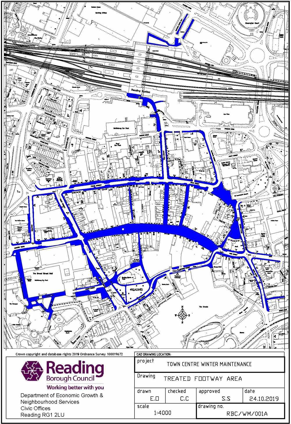
Appendix E
Footways – snow clearing/pre-salting
Reading town centre block paved areas (treatment with proprietary material/salt/grit)
| Street name | Section |
|---|---|
| Broad Street | All |
| Butter Market | All |
| Chain Street | All |
| Cheapside | All |
| Cross Street | All |
| Duke Street | King Street to Star Lane |
| Dusseldorf Way | All |
| Friar Street | Part – block paved areas only |
| Gun Street | All |
| Hosier Street | All |
| King Street/Kings Road | Part – Minster Street to Abbey Square |
| Minster Street | All |
| Market Place | All |
| Queen Victoria Street | All |
| Queen’s Walk | All |
| Reading Station | Part – Defined pedestrian route swathe on public highway from Station Road to Station Hill (Taxi Rank shelter) via pedestrian ramp and continuing to pedestrian underpass (south side). Also from pedestrian underpass (north side) to Trooper Potts Way (bus shelters). |
| St Mary’s Butts | All |
| Station Road | All |
| Union Street | All |
| West Street | All |
Drawing of treated footway areas in town centre
Appendix F
Call out facilities
Outside office hours
Call Civic Offices Security on 0118 937 3787 (calls are charged)
Appendix G
Grit bin locations
| Area | Road | Location | Bins |
|---|---|---|---|
| North | Blenheim Road, Caversham | Facing junction with Oakley Road | 1 |
| North | Brill Close | Top of Close. Outside No. 25 | 1 |
| North | Crawshay Drive | Junction with Kidmore End Road. Adjacent to Street Nameplate | 1 |
| North | Eliot Close | Junction with Grove Hill | 1 |
| North | Fallowfield Close | End of wooden fence part way down Close | 1 |
| North | Glenrhondda | Near No. 14 | 1 |
| North | Gravel Hill | Opposite Numbers 31 & 33 near Merthyr Vale junction. | 1 |
| North | Grove Hill | Mid way. Against high wall | 1 |
| North | Hemdean Road | Near Badgers Rise | 1 |
| North | Highdown Hill Road | Junction with Soane End (Private Drive) | 1 |
| North | Horse Close | On island near No. 26 | 1 |
| North | Hunters Chase | Adjacent to lamp column No. 12 | 1 |
| North | Keston Close | Junction with Donegal Close. (Right hand side) | 1 |
| North | Luscombe Close | Back against picket fence line. Right hand side | 1 |
| North | Picton Way | Junction mid-way up hill. Adjacent to Street Nameplate | 1 |
| North | Ruskin | On bend | 1 |
| North | Russet Glade | Mid-way at brow of hill | 1 |
| North | Scott Close | Adjacent to lamp column. Against brick wall | 1 |
| North | Sheriden Avenue | Outside No. 2 at junction with Hemdean Road | 1 |
| North | Surley Row | Junction with Sheep Walk | 1 |
| North | Tredegar Road | By railings | 1 |
| North | Tredegar Road | Junction with Glenrhondda | 1 |
| North | Tymawr | Opposite No. 21 (Off Hunters Chase) | 1 |
| North | Upper Warren Avenue | Near junction with St Peters Avenue | 1 |
| West | Brooksby Road | Junction with Juniper Way. Outside No. 110 in grass verge | 1 |
| West | Calder Close | On corner of junction | 1 |
| West | Carlisle Road | Junction with A329 | 1 |
| West | Dudley Close | Near junction with Armour Hill | 1 |
| West | Dulnan Close | Near Elderly Persons flats | 1 |
| West | Elsley Road | Junction with Oxford Road. In grass verge at end of footway | 1 |
| West | Oak Tree Road | Opposite Numbers 49 & 51 | 1 |
| West | Little Oaks Drive | At junction with Oaks View | 1 |
| West | Pottery Road | Near junction with Dresden Way | 1 |
| West | Rissington Close | By lamp post outside No. 5 | 1 |
| West | Rodway Road | At corner of Derwent Avenue | 1 |
| West | Romany Lane | Junction Romany Close | 1 |
| West | Sandgate Avenue | Near junction with Grasmere Avenue | 1 |
| West | Taff Way | Near junction with Dee Road | 1 |
| West | Thurso Close | Dee Road Estate. In grass verge opposite block of flats | 1 |
| West | Ullswater Drive | Junction with Elsley Road | 1 |
| South | Alpine Street/Elgar Road | Back against gable wall of No. 25 Elgar Road | 1 |
| South | Barnsdale Road | Opposite Windermere Road junction in grass verge | 1 |
| South | Birdhill Avenue | Junction with Cressingham Road | 1 |
| South | Blagdon Road | 1no. near Cherry Grove junction.1no. opposite Bankside Close. Both i) & ii) secured to single steel posts | 2 |
| South | Brybur Close | Junction with Winton Road | 1 |
| South | Ennerdale Road | Corner Northcourt Avenue | 1 |
All of the above grit bins have achieved a score of at least 60 out of a total of 85 points to qualify.
Appendix H
Location of structures to receive ‘double pre-salt’ salting
| Road no. | Location | Structure |
|---|---|---|
| A329 | Watlington Street | River Kennet Overbridge |
| A329 | King’s Road | River Kennet Overbridge |
| A329 | Watlington Street Northbound | Kennet Canal Overbridge |
| A329 | Watlington Street Southbound | Kennet Canal Overbridge |
| A329 | IDR Eastbound | Mill Lane Flyover |
| A329 | IDR Westbound | Mill Lane Flyover |
| A329 | Chatham Street Eastbound | IDR Overbridge |
| A329 | Chatham Street Westbound | IDR Overbridge |
| A329 | Castle Hill Eastbound | IDR Overbridge |
| A329 | Castle Hill Westbound | IDR Overbridge |
| A33 | A33 Northbound | River Kennet Overbridge |
| A33 | A33 Southbound | River Kennet Overbridge |
| A33 | A33 Northbound | Foundry Brook Overbridge |
| A33 | A33 Southbound | Foundry Brook Overbridge |
| A33 | M4 Junction 11 West | Motorway Overbridge |
| A33 | M4 Junction 11 East | Motorway Overbridge |
| A4 | Berkeley Avenue | A33 Relief Road Overbridge |
| A4 | Bath Road | Rail Overbridge |
| A4155 | Bridge Street Caversham | River Thames Overbridge |
| B3345 | George Street Caversham | River Thames Overbridge |
Appendix I
Winter service cross boundary arrangements
The cross boundary arrangements have been reviewed and risk assessed.
Reading Borough Council will salt up to a point beyond the Borough boundary where it is safe for the gritter vehicle to turn around. With agreement, the neighbouring Councils are similarly working to ensure that all of the cross boundary highway network is treated.
This does not constitute any form of agreement or responsibility for the treatment of the highway network outside the Borough boundary, it is merely to ensure full coverage of the Council’s salting network.
Appendix J
Map showing Winter Salting Routes 2022-2023
Appendix K – Circulation list
1. Adjoining highway authorities
1.1 Wokingham Borough Council, Shute End, PO Box 153, Wokingham RG40 1WL
0118 9746000
1.2 West Berkshire District Council, Council Offices, Market Street, Newbury RG14 5LD
01635 551111
1.3 Oxfordshire County Council, Director of Environment and Economy, Speedwell House, Speedwell Street, Oxford OX1 1NE
01865 815700
2. Emergency services
2.1 Thames Valley Police, Police Headquarters, Kidlington, Oxford OX5 2NX
2.2 Royal Berkshire Fire and Rescue Service, Newsham Court, Pincents Kiln, Calcot, Reading RG31 7SD
0118 945 2888
2.3 Royal Berkshire Ambulance NH Trust, 44 Finchampstead Road, Wokingham, RG40 2NN
0118 936 5500
3. Highways England’s agents
EM Highway Services Ltd, Rosalind House, Jays Close, Viables Business Park, Basingstoke, Hampshire RG22 4BS
4. Media organisations
4.1 BBC Radio Berkshire, 550 Thames Valley Park Drive, Reading RG6 1PT
radio.berkshire.news@bbc.co.uk
4.2 Heart FM, PO Box 2020, Reading RG31 7FG
thamesvalley.news@heart.co.uk
4.3 The Breeze (radio station), Suite 2, Paddington House, Festival Place, Basingstoke RG21 7LJ
tvnews@celador.co.uk
5. Motoring organisations
5.1 RAC, Public Affairs Dept, 114 Rochester Row, London
5.2 Automobile Association, Fanum House, 52 London Road, Twickenham, Middlesex
6. Councillors Suite
Reading Borough Council, Civic Offices, Bridge Street, Reading RG1 2LU
Appendix L
References
- Highways Act 1980
- Highways Winter Maintenance, ICE 2000
- Well Maintained Highways – Code of Practice for Highway Maintenance Management 2005 (revised 2009, 2010 and 2011)
- Lessons from the Severe Weather February 2009
- The Resilience of England’s Transport Systems in Winter Interim Report, July 2010
- Quarmby Audit Report December 2010 (revised 2011)
- Well-managed Highway Infrastructure: A Code of Practice – October 2016
- Winter Service Plan 2022/2023 Strategic Environment, Planning and Transport Committee Report 9 November 2022
Last updated on 16/11/2022
Winter Service Plan 2022 – 2023