Reading Transport Strategy 2040 – published June 2024
Contents
- Foreword
- Executive summary
- Introduction
- Vision and objectives
- Our vision for transport in Reading
- About Reading
- Challenges and opportunities
- Our policies
- Our schemes and initiatives
- Funding and implementation
- Partnerships and stakeholders
- Monitoring and review
- Glossary
- References
Foreword, by Councillor John Ennis
This is the most important Transport Strategy that Reading will ever produce. The Climate Emergency is happening now and it is not something any of us should ignore. Alongside the need to recover and learn lessons from the Covid pandemic, including addressing inequalities in our society. The new strategy is our most radical yet and reflects the fact that the status quo is not an option.
Over the following pages you can read about how our plans will help to combat the poor air quality polluting some parts of our town, and how our policies will contribute towards our objective to create a net zero carbon Reading by 2030. It includes schemes some people may find controversial. I make no apology for that. The only way we can hope to tackle the congestion and pollution which blights some areas of Reading is by doing things differently.
Reading has one of the UK’s fastest growing economies, despite the impact of the Covid pandemic and other global factors, and we understand that improved transport options are critical to creating more jobs and opportunities for residents. It is a major centre for employment, leisure and education in the Thames Valley region and home to many national and international companies. Demand for new homes has never been higher. But with that success come serious challenges in terms of pressure on our transport infrastructure, commuter congestion and poor air quality.
The challenge will only intensify in the coming years with many thousands of new homes being built, particularly just outside of Reading. Many of those new residents will commute into Reading for work and must be offered attractive and reliable alternatives to the private car.
Early evidence suggests that a significant proportion of traffic in Reading is through-traffic, particularly on the IDR and the two bridges over the river Thames. It is not acceptable for the many thousands of vehicles and lorries who have no origin, destination or purpose in Reading to continue to use the town as a short cut, causing additional congestion, polluting our air and damaging our health. This document will help tackle that injustice. It is a situation no responsible local authority can ignore.
Our challenge is to successfully absorb the growth in housing, jobs and commuting, whilst protecting the health of residents. Our Transport Strategy to 2040 is a plan to do that. It has been designed following substantial public consultation which produced a record number of responses and showed very strong support for a more sustainable future. Thank you to the over three thousand people who have provided comments through our consultations and helped to shape the Transport Strategy, and we look forward to continuing to engage with you as we now start to implement and deliver the schemes and policies.
This strategy provides high quality and realistic alternatives to the private car through new and upgraded railway stations, new park and rides and quick, reliable public and affordable transport routes. It includes major new schemes to promote and strengthen public transport links, including a fundamental review of options to improve sustainable travel over the River Thames to reduce congestion and improve air quality for residents. It includes new pedestrian and cycle routes, and the infrastructure to support it. It includes demand management schemes, to remove the most polluting vehicles from our streets, particularly those with absolutely no business in Reading. This strategy also outlines how we will work with partners to fund and to help deliver the vision.
We are building on strong foundations. In recent years we have overseen the complete transformation of Reading Station; delivered the new station at Green Park; built Christchurch Bridge, the new pedestrian and cycle bridge over the Thames; created new park & ride sites at Mereoak, Winnersh and Thames Valley Park; built the initial phases of South Reading BRT and delivered the cross-town National Cycle Network 422 route.
In addition, we are delivering a significant programme of bus improvements through securing £26m grant funding from government, alongside delivering new segregated cycle facilities on key routes at Shinfield Road and Bath Road. Our investment has resulted in significant increases in sustainable travel in Reading.
Bus use was the second highest in the whole country outside London pre-pandemic, and sustainable travel, including walking and cycling, now accounts for around 75% of trips to and from the town centre.
As you will see, we want to transform travel options in this period by delivering high-quality and realistic alternatives to the private car. This will bring significant benefits for the environment and climate crisis, the health and wellbeing of residents, enable sustainable economic growth, unlock local job opportunities and deliver new homes to the highest environmental standards.
Future travel in and around Reading must be affordable and accessible to reduce the considerable inequalities in our communities. It must improve residents’ health and wellbeing, whilst supporting a growing and inclusive economy. We recognise that difficult choices will need to be made to address the climate crisis and improve air quality for residents. Embracing rapidly changing technology and being responsive to innovation will be fundamental to achieve our vision for the town.
We want to work together to achieve a sustainable and prosperous future for everybody in Reading. We have achieved a great deal, but we have much more to do. This is how we do it.
Executive summary
Introduction
The Reading Transport Strategy 2040 is a statutory document that sets the plan for developing our town’s transport network to 2040 and beyond. It includes the guiding policies and principles, alongside schemes and initiatives to be delivered, to enable us to achieve our overall vision for a substantial change in modal shift to support sustainable travel choices in Reading.
The strategy is focused primarily on improvements within Reading borough for local residents. However, due to the compact geography of the Local Authority area, it also includes cross- boundary schemes and initiatives partly within neighbouring local authorities which form part of the wider Reading urban area.
This strategy has been developed in partnership with local residents, businesses and stakeholders through extensive consultation which was undertaken in 2019 and 2020. It has been informed by an integrated impact assessment, which has considered the impacts of the plan on the environment, health, and equalities issues. In addition to satisfying statutory requirements, this has helped to shape the content of the Reading Transport Strategy in order to maximise beneficial effects for local communities and the environment.
Our vision and objectives
We want Reading to be a great place to live, work, study and play. We have formed a vision for our town, by coming together with local businesses, community groups and Reading University to plan for Reading’s future. The result is the Reading 2050 Vision, an ambitious description of what Reading can be; a green tech city, a city of culture and diversity, and a city of rivers and parks.
The Reading 2050 Vision identifies key elements for its delivery, including a number in which transport plays a major part. Transport will be critical to enhancing the connectivity needed to facilitate sustainable economic growth and enable everyone to enjoy the multitude of assets the town has to offer. The way in which we deliver this will be key to low carbon living, and creating the green and healthy spaces to allow our communities to thrive. Technology will support our transport network, facilitating smart and efficient solutions, and maximising the impact that transport can make.
The Reading Local Plan vision, which sets out in more detail a vision for Reading in 2040, and considers the context of the longer-term direction of travel to 2050, is informed by the Reading 2050 Vision.
The Reading 2050 Vision and our Local Plan have informed our approach to delivering the transport elements of this overall vision for Reading.
Key factors include changing travel patterns and future technology, the climate emergency, opportunities to enable healthy lifestyles, promote sustainable economic growth and reduce inequalities by ensuring everyone can benefit from the success of our town.
To help us deliver our overall vision for Reading, we have developed a supporting transport vision for this strategy.
“Our vision is to deliver a sustainable transport system in Reading that creates an attractive, green and vibrant town with neighbourhoods that promote healthy choices and wellbeing. Future mobility options will enable everyone in Reading to thrive, enjoy an exceptional quality of life and adapt to meet future challenges and opportunities.”
Five objectives underpin our vision, taking into account the future challenges we will face and the opportunities we will embrace:
Creating a clean and green Reading
Provide transport options to deliver modal shift, enhance quality of life, reduce emissions and improve air quality to create a carbon neutral town.
Supporting healthy lifestyles
Create healthy streets to encourage active travel and lifestyles, improve accessibility to key destinations and increase personal safety.
Enabling sustainable and inclusive growth
Enable sustainable growth and connect communities so that everyone can benefit from Reading’s success.
Connecting people and places
Promote the use of sustainable modes of transport by providing attractive alternatives to the private car, helping to provide a transport network that is fast, affordable, connected and resilient.
Embracing smart solutions
Use technology to manage the network efficiently and allow informed travel choices, whilst enabling Reading to become a smart, connected town of the future.
We are building on success through our significant investment in the transport network in recent years. We have provided new and upgraded transport infrastructure to encourage people living, visiting and working in Reading to use sustainable transport including the major redevelopment of Reading Station and associated Cow Lane Bridges scheme, new Park and Ride facilities, Reading Green Park Station, initial phases of the South Reading Bus Rapid Transit corridor, Christchurch Bridge and the National Cycle Network route 422.
About Reading
Reading is an important and strategic location in the South East. The borough was home to around 174,000 people in 2021, with a further 59,000 in the wider urban area. The population of the area is forecast to grow over this plan period. Reading is also a major centre of employment, with around 121,000 people working in the borough. There are more jobs in Reading than workers, so people travel in from other areas to work. The centre of Reading is also a major retail and leisure destination, with The Oracle ranked in the top 50 shopping centres in the UK.
The town’s location on both the Great Western Main Line and the M4 motorway makes it a major hub for transport movement. Reading Railway Station is one of the busiest railway stations outside London and marks the western terminus of the Elizabeth Line. Reading also has excellent connections to the international transport hubs at Heathrow and Gatwick Airports. In addition, Reading’s location on the Kennet & Avon Canal and River Thames and at the meeting point of several national cycle routes, gives it significance for a variety of other modes of travel. Such connectivity is represented by Reading’s status as a regional transport hub, international gateway and a major transport interchange.
Due to our success in investing in sustainable travel options, trips to/from central Reading by public transport, walking, and cycling increased significantly between 2008-10 and the Covid-19 pandemic. Whilst Covid-19 resulted in a drastic reduction in town centre trips, total trips are now recovering towards pre-Covid levels, with a relatively strong recovery in the number of trips made by sustainable modes, and a sharp increase in the number of trips made by cycle, with close to a doubling of trips since 2008-10. The increase in car and taxi trips since our emergence from the pandemic appears to be plateauing at levels below those seen pre-Covid, indicating that some sustainable travel patterns adopted during Covid are likely to have become long-term travel behaviours for people.
Challenges and opportunities
We have identified seven key transport challenges facing us:
Adapting to the future
We know that we are in the midst of a climate crisis. This, alongside fast changing technological innovation, means the future is uncertain and Reading will need to adapt, through both decarbonisation and accepting the need to travel more sustainably. This will affect the way we travel and transport goods, whilst at the same time provide new and innovative opportunities for society.
Improving air quality
As a result of the high levels of car congestion and accompanying air pollution in parts of Reading, an Air Quality Management Area (AQMA) has been declared covering the town centre and key corridors into and out of the town. The negative effects of poor air quality are serious: up to 36,000 people in the UK die as a result of air pollution every year. Technologies are developing that are reducing the level of pollution vehicles emit from exhausts, and the UK is shifting towards electric vehicles. However, around 85% of fine particulate pollution from vehicles does not come from traditional fuel types and exhausts, and so a reduction in vehicle usage is the only measure that will improve air quality further.
Reducing congestion
Whilst Reading has high levels of bus usage and the main railway station is one of the busiest outside London, a significant proportion of people travelling into or out of the borough for work travel by car. This makes Reading one of the most congested places in the UK – central government statistics indicate that Reading has significantly high levels of delays on A roads compared to other local authorities outside of London. Due to a lack of alternative strategic north-south connections there are high levels of through-traffic in Reading, which have no origin or destination within the borough. This adds to congestion in the town centre, on the bridges over the River Thames and along key corridors.
Providing affordable and accessible travel for all
Despite economic growth, Reading has seen an increase in the number of areas which fall into the UK’s most deprived 10%, from zero in 2010, to five today. The availability, accessibility and affordability of public transport and the provision of walking and cycling facilities are critical to ensuring equality of opportunity and connectivity across the Reading area.
Removing barriers to healthy lifestyles
Many of our public spaces and streets require improvements to make them more attractive and welcoming, with better provision to encourage more people to choose to walk and cycle, as well as providing greater independence for those who are mobility impaired. Our local pedestrian and cycle networks are extensive, but there are still gaps that cause disconnect, and parts where the route quality needs improvement and priority given to sustainable travel over private car use to support healthy lifestyles.
Achieving good accessibility to local facilities and employment
Within Reading, access to local facilities and employment varies significantly, depending both on the type and the location. It is important that existing local facilities including the Royal Berkshire Hospital and schools are served by high-quality, frequent bus services, in order to reduce car travel, and to enhance access to amenities for people who do not own a car.
Similarly, the availability of sustainable travel options to employment is important to increase access to employment for all users, including vulnerable groups, and to reduce congestion across the network. New developments have the opportunity to deliver facilities that serve both new residents or employees, and existing communities in the local area, contributing towards a shift to sustainable travel and also increasing social cohesion.
Accommodating development
Economic success and growth in Reading is forecast to continue and substantial house building is planned in both Reading and neighbouring authority areas. Between 2013 and 2036 an additional 2,600 homes are planned to be built each year in the local area and population growth will mean more trips on our network each day. The Reading Transport Strategy (RTS) will help us to deliver our Local Plan as well as those of neighbouring authorities.
Our policies
Our policies set the guiding principles for our strategy to ensure we will achieve our overall vision and objectives. These policies cover a range of topics including:
- Multi-modal policies including sustainable transport, equality and inclusivity, the environment and climate change.
- Public transport policies including rail, buses, taxis and private hire vehicles, waterways, mobility as a service, shared autonomous vehicles and travel information.
- Active travel policies including healthy streets, public space, walking and cycling, school travel, and public rights of way.
- Network management policies including road safety, parking and enforcement, motorcycles, freight, smart solutions and highway asset management.
- Communication and engagement policies including training and education, incentivisation and public engagement.
Our schemes and initiatives
We will implement our policies through the delivery of schemes and initiatives to improve transport in the area and meet our aims and objectives. This Local Transport Plan has been developed so that our transport strategy considers the wider environment and is inclusive of all types of transport users.
Our strategy includes a wide range of schemes and initiatives from localised small-scale enhancements to strategic cross-boundary major schemes, including:
- Multi-Modal schemes, including major transport corridors, cross-Thames travel, connecting neighbourhoods and enhancements to the Inner Distribution Road (IDR). This will also include investigating demand management schemes
- Public transport schemes, including upgrades and enhancements to railway stations, bus rapid transit corridors, Park and Rides, Superbus network, community transport, concessionary travel, Mobility as a Service and demand responsive transport
- Active Travel Schemes, including public space enhancements, strategic and local pedestrian and cycle routes, safer school travel, micro- mobility hire and cycle parking and mobility hubs
- Network management schemes, including neighbourhood and highway management, parking schemes and management, road safety schemes, intelligent transport systems, electric vehicle charging, car clubs and smart city initiatives
- Communication and engagement schemes, including marketing, travel information, training, school travel accreditation programme, progress reporting and public engagement
Funding and implementation
Our implementation plan sets out our indicative delivery programme for future transport schemes and initiatives to 2040. The schemes and initiatives set out in this strategy are not fully funded, therefore we will continue to seek external funding to enable us to deliver the overall strategy.
Funding sources will include grants and private sector contributions and will be supplemented by both capital and revenue Council funding and services delivered on a commercial basis. The implementation of demand management measures may provide an additional revenue stream to invest in and enhance sustainable transport options.
We will investigate potential new and innovative funding sources, such as corporate partnerships and private investment, and also seek to reduce costs, where appropriate.
Delivery of the strategy will be split between major schemes, packages of smaller measures delivered through our neighbourhood area action plans, and on-going revenue initiatives.
Partnerships and stakeholders
Our strategy is ambitious, therefore it will be critical to work in partnership with key stakeholders to achieve its successful delivery. This will include, but not be limited to, neighbouring authorities, local communities, education providers, public services and businesses to take account of their diverse needs and aspirations when delivering this strategy.
We participate in a number of key formal and informal partnerships to support a joined up, overarching approach to delivery of our key services and future plans. This enables us to lobby for wider transport improvements and funding (for instance the major redevelopment of Reading Station), therefore we will continue to develop these partnerships throughout the strategy period to achieve the best possible results for Reading and its local communities. Our key delivery partners are:
National / Regional
- Central government including Department for Transport
- Transport for the South East
- Network Rail
- National Highways
Neighbouring Local Authorities
- Wokingham Borough Council
- West Berkshire Council
- Bracknell Forest Borough Council
- Hampshire County Council
- Oxfordshire County Council
- South Oxfordshire District Council
- Local parish and town councils
Transport Operators
- Train operators including Great Western Railway and South Western Railway
- Bus operators including Reading Buses, Arriva, and Thames Travel
- Community transport operators including Readibus
- Reading taxi associations
Major Organisations
- Education providers including the University of Reading, colleges and schools
- Public services including the Royal Berkshire Hospital
Local Community
- Community groups and local residents
- Private sector including local businesses
- Local media
- Local interest groups
Monitoring and review
Performance monitoring is key to manage and improve the delivery of our strategy programme. We have identified a number of key performance indicators and targets which set our ambitions to transform travel options in Reading and enable us to measure progress against achieving our overall vision and objectives.
These targets relate to significantly increasing usage of sustainable transport, improving air quality and reducing carbon emissions, improving road safety and improving public satisfaction with travel in Reading.
Given the longer-term time-scales of this strategy, it will be regularly reviewed to ensure it remains current and that it is best placed to respond to future needs and opportunities as they arise.
Introduction
Purpose
1.1 The Reading Transport Strategy 2040 is a statutory document (known as a Local Transport Plan) that outlines the high-level policy and strategy for transport to meet existing and future transport demand in the town to 2040.
1.2 This strategy sets out how transport can play its part in delivering Reading’s 2050 vision and Reading’s Local Plan, to make Reading a great place to live, work, study and play. It outlines our approach for all types of transport in Reading and seeks to embrace opportunities to adapt to changing travel demands and new technologies.
1.3 Key considerations in developing the plan include the climate change emergency, enabling healthy lifestyles, promoting social inclusion, sustainable economic growth, increasing productivity and forecast population and housing growth. This document replaces the current Local Transport Plan (LTP) and looks ahead to 2040.
1.4 In preparing this plan, we have identified the challenges we need to tackle, and have established a high-level vision and focused objectives, under our five themes: creating a clean and green Reading; supporting healthy lifestyles; enabling sustainable and inclusive growth; connecting people and places; and embracing smart solutions. This has been informed through the consultations carried out in 2019 and 2020, which sought the views of residents, schools and businesses. This analysis and consultation has enabled the identification of new schemes, initiatives and policies to transform transport options in the area.
1.5 Reading’s transport strategies have always been valuable platforms for jointly developing and communicating our plans and programmes for improving transport with the local community. They have enabled engagement and partnership working with other organisations and key stakeholders, including our neighbouring authorities and local and national transport operators. Our strategy is also an important tool to ensure we deliver improvements efficiently and that these achieve best value for money.
1.6 Excellent progress has been made in delivering significant transport improvements in Reading since our first LTP in 2001. This is summarised in the About Reading chapter. This plan builds on our approach and past success, taking our longer-term strategy forward to 2040, in line with our Local Plan which sets the spatial planning strategy for the area.
Our approach
1.7 The Reading Transport Strategy (RTS) is supported by an Integrated Impact Assessment, which includes our Strategic Environmental Assessment, Health Impact Assessment and Equalities Impact Assessment to ensure the impacts of the plan provide positive benefits and meet relevant legislation in these key areas.
1.8 Our strategy is focused primarily on Reading borough. However, due to the compact nature of the Local Authority area, it also includes schemes within the wider Reading urban area.
1.9 Given the longer-term timescales for this strategy, it will be regularly reviewed and evolved to keep it current and to ensure it is best placed to respond to future needs and opportunities as they arise. The evolving strategy will be adaptable to future challenges and new technologies.
1.10 A key focus of this strategy is to ensure the needs of Reading’s growing population and economy are developed in a sustainable way that supports the Council’s commitments to addressing climate change. The RTS therefore aims to influence decisions about where future housing should be located both within and outside the borough. Growth should be directed to places where sustainable travel options can be made more attractive and therefore provide a viable alternative to private car trips.
1.11 Our strategy details our long-term vision for transport in Reading and the transport objectives which support this. Chapter 5 sets out the challenges and opportunities the plan will address. It reviews the current and expected future needs of people to travel to and around Reading against the capacity and quality of the infrastructure and services to meet these needs. Schemes to help resolve or embrace these challenges and opportunities are further identified in this chapter at strategic and neighbourhood area levels.
1.12 Our transport vision and objectives have influenced the preparation of a set of policies relating to transport modes and themes. Supporting sub strategies provide more detail on the objectives and actions proposed for certain thematic topics, such as walking and cycling, our Bus Service Improvement Plan, parking, school travel and public rights of way.
1.13 We have set out the likely mechanisms which will enable us to fund our proposals, alongside our approach for ensuring value for money in transport investment, and monitoring arrangements to track our progress.
Consultation and engagement
1.14 The RTS has been developed to ensure that the strategies, decisions and implementation of transport schemes reflect the needs of local residents. A wide range of consultation and engagement has been undertaken with residents and key local stakeholders to allow them to influence and shape the development of the plan.
1.15 At the beginning of the development of our new strategy, we consulted comprehensively with local residents, businesses and key stakeholders to understand local views to help set the main themes and objectives that underpin the strategy. This included surveys, a website, public drop-in sessions and workshops with key stakeholders and interest groups. We sent leaflets to over 70,000 households and 3,800 businesses. Direct engagement was held with around 750 people at various events within the borough, and 2,881 responses were gathered through our online survey.
1.16 There was an overwhelming level of public support for the five strategic objectives that underpin the RTS, with 90% of responses expressing agreement. Our vision for transport in Reading and the strategic objectives to deliver our vision are set out in Section 2 of this document.
1.17 Sustainable travel is fundamental to each of the five strategic objectives. Increasing public transport patronage is essential to this, and 94% of responses indicated support for extending the public transport network with more frequent services to schools, workplaces and isolated areas, as a means to increase public transport use.
1.18 To further promote sustainable travel, significant support was shown towards the implementation of car-free spaces (90%), reallocating road space for sustainable transport (75%), as well as improving the connectivity of the walking and cycling network in Reading (92%).
1.19 There was also a significant level of support for delivering demand management measures with 60% of respondents stating they thought a charging scheme would be effective in reducing the number of private vehicles on the road.
1.20 Statutory consultations on the draft RTS were held in summer 2020 and autumn 2023,
with the RTS being updated between the two consultations to reflect consultation feedback, the long-term impacts of Covid-19 and policy developments in the interim.
1.21 The 2020 and 2023 consultations resulted in over 200 and over 500 responses respectively, including detailed responses from statutory consultees such as transport operators and neighbouring authorities.
1.22 Key stakeholders highlighted through the consultation process that they are keen to continue to work with us to plan, develop and deliver schemes, and were generally supportive of the strategy.
1.23 Our 2023 Consultation Report, published separately, sets out how feedback from the 2023 consultation has informed a number of changes incorporated into this adopted version of the Reading Transport Strategy.
Evidence base
1.24 A significant base of evidence has been used to underpin the development of this strategy, using national, regional and local data. We have analysed this data to develop our policies, schemes and initiatives.
1.25 There are seven local areas in and around Reading, representing the town centre and the six main transport corridors radiating from central Reading. Information for each area has been considered, including the demographics, movement characteristics, planned and committed development and infrastructure proposals.
1.26 We will develop action plans for each neighbourhood area that enable us to identify and prioritise local transport measures that will deliver value for money and positive outcomes in respect of our overall strategy vision and objectives. Our approach will ensure that existing assets are used as effectively as possible and the benefits of upgraded or new infrastructure will therefore be maximised.
1.27 Our plans will be progressed in partnership with appropriate neighbouring authorities where these extend beyond our administrative boundaries. These will be shaped by consultation with our partners, stakeholders and local communities.
Integrated impact assessment
1.28 The RTS is supported by an Integrated Impact Assessment (IIA) which has been undertaken in tandem with developing the plan. An IIA Report was published for consultation in tandem with the previous draft RTS, and the IIA has been updated for this latest version of the RTS.
1.29 The purpose of the IIA is to identify, assess and address likely significant effects on the environment and likely effects on health and equalities from the emerging RTS. In doing so, the IIA has helped to shape the content of the RTS in order to maximise its sustainability and socio-economic performance.
1.30 The IIA incorporates a suite of statutory and non-statutory impact assessments:
- Strategic Environmental Assessment (SEA)
- Equalities Impact Assessment (EqIA)
- Health Impact Assessment (HIA)
1.31 These impact assessments have been undertaken in a co-ordinated manner to support development of the RTS. The SEA element of the IIA identifies the likely significant effects on the environment, whilst the EqIA and HIA elements identify likely different impacts on demographics groups and persons with protected characteristics (in accordance with the Equality Act 2010) and on health outcomes respectively. The HIA element of the IIA was undertaken on a non-statutory basis to support demonstrating compliance with SEA and EqIA requirements relating to the assessment of likely health effects in an integrated manner.
1.32 In accordance with statutory SEA requirements, we consulted on our IIA Scoping Report both within the Council and with the Environment Agency, Natural England and Historic England in Autumn 2018. The Scoping Report:
- Defined an evidence-based suite of key issues which should be addressed in the RTS; and,
- Defined an integrated assessment framework to underpin the testing, assessment and refinement of all components within the emerging RTS (objectives, schemes, policies, etc).
1.33 Taking account of consultee feedback, the IIA has been undertaken on an iterative basis in tandem with developing the RTS itself. As detailed within the accompanying IIA Report this allowed any uncertainties, issues or mitigation requirements identified during the IIA to be addressed in the RTS. In addition to meeting statutory requirements this iterative process has maximised the sustainability and socio-economic performance of the RTS.
Vision and objectives
Our vision for Reading 2050
2.1 We have formed a vision for our town, by coming together with local businesses, community groups and the University of Reading to plan for Reading’s future.
2.2 The result is the Reading 2050 Vision, an ambitious description of what Reading can be, with three themes central to Reading’s long term success as a smart and sustainable city. These three themes are:
- A green tech city
- A city of culture and diversity
- A city of rivers and parks
Our vision for Reading 2050 is “an internationally recognised and economically successful city region, where low carbon living is the norm and the built environment, technology and innovation have combined to create a dynamic, smart and sustainable city with a high quality of life and equal opportunities for all”
2.3 Six vision statements were identified to bring the themes together and describe what success looks like. These identified the aim for Reading to be a place that:
- Shares success to support and enable thriving communities
- Delivers a real sense of place and identity
- Thrives on cultural and cross-generational diversity
- Recognises our heritage and natural assets
- Embeds technology to deliver innovation and low carbon living for all
- Welcomes ethical and sustainable businesses who support Reading
2.4 The Reading 2050 Vision identifies key elements for its delivery, including a number in which transport plays a major part. Transport will be critical to enhancing the connectivity needed to facilitate economic growth and enable everyone enjoy the multitude of assets the town has to offer. The way in which we deliver this will be key to low carbon living, and creating the green and healthy spaces to allow our communities to thrive. Technology will support this, facilitating smart and efficient solutions, and maximising the impact that transport can make.
2.5 The Reading Local Plan vision, which sets out in more detail a vision for Reading in 2036, and considers the context of the longer-term direction of travel to 2050, is informed by the Reading 2050 Vision.
Our vision for transport in Reading
2.6 This Reading Transport Strategy (RTS) will help to deliver both the Reading 2050 and Reading Local Plan visions, through an ambitious programme of measures to enable and encourage sustainable travel choices in the town by 2040, with the intent that future transport strategies will continue to support the Reading 2050 vision in the longer term.
2.7 Climate change is the defining crisis of our time, but we have the power to face it and avoid its devastating consequences. Our vision for transport and the supporting policies and schemes will help us take action to reduce our contributions towards climate change, and adapt to protect us from the impacts of climate change.
2.8 In order to achieve our ambitions, we will need to embrace emerging opportunities and our strategy will need to be adaptive to innovation. Travel demand in the future will be affected by changes in technology and wider society. The extent and pace of change is not certain, however it is clear that innovations such as driverless and connected vehicles and new approaches to the provision of transport will bring the potential for historic transport trends to change significantly, and our ambition is for residents of Reading to be at the forefront of benefiting from these opportunities.
“Our vision is to deliver a sustainable transport system in Reading that creates an attractive, green and vibrant town with neighbourhoods that promote healthy choices and wellbeing. Future mobility options will enable everyone in Reading to thrive, enjoy an exceptional quality of life and adapt to meet future challenges and opportunities.”
2.9 Our overarching vision for transport in Reading has been aligned to our wider vision for the town in 2050, our Local Plan, and relevant national, regional and local policies.
Our objectives
2.10 Our strategic objectives have been developed as the guiding principles running through this strategy to ensure and set out how we will measure our success in delivering our vision for transport in Reading.
 Creating a clean and green Reading
Provide transport options to enhance a quality of life, reduce emissions and improve air quality to create a carbon neutral town.
 Supporting healthy lifestyles
Create healthy streets to encourage active travel and lifestyles, improve accessibility to key destinations and increase personal safety.
 Enabling sustainable and inclusive growth
Enable sustainable growth and connect communities so that everyone can benefit from Reading’s success.
 Connecting people and places
Promote the use of sustainable modes of transport by providing attractive alternatives to the private car, helping to provide a transport network that is fast, affordable, connected and resilient.
 Embracing smart solutions
Use technology to manage the network efficiently and allow informed travel choices, whilst enabling Reading to become a smart connected town of the future.
Our transport vision is supported and informed by wider polices and guidance that: set out how Reading can foster economic growth; become an activity hub in the Thames Valley; improve sustainability in the town; and work in partnership with other authorities to achieve this.
National policy and guidance
Transport Decarbonisation Plan
2.11 ‘Decarbonising Transport: A Better Greener Britain’ sets out the government’s plans to decarbonise transport in the UK, to meet carbon net-zero in 2050. It outlines strategic priorities:
- Accelerating modal shift to public and active transport
- Decarbonising road transport
- Decarbonising how we get our goods
- UK as a hub for green transport technology and innovation
- Place-based solutions to emissions reduction
- Reducing carbon in a global economy
2.12 The plan also identifies actions and makes a plethora of commitments to deliver these priorities.

Gear Change
2.13 ‘Gear Change: A bold vision for walking and cycling’ is the government’s plan to deliver a step change in walking and cycling levels. It outlines the significant impacts on health and wellbeing, air quality, climate change, inequality and congestion that increased walking and cycling levels could have, and sets a vision for England to be a walking and cycling nation. It sets out actions required to deliver this under four themes:
- Better streets for cycling and people
- Putting cycling and walking at the heart of transport, place-making and health policy
- Empowering and encouraging local authorities
- We will enable people to cycle and protect them when they cycle
National Bus Strategy
2.14 ‘Bus Back Better’ sets out the government’s vision for the future of buses, delivering service and quality improvements and increasing patronage. It outlines the requirements for local authorities to establish Enhanced Partnerships with operators and to publish a Bus Service Improvement Plan, alongside identifying detailed actions that are needed to deliver the vision.
Plan for Growth
2.15 ‘Build Back Better: our plan for growth’ sets out the government’s plans to support economic growth through significant investment in infrastructure, skills and innovation. The Plan aims to level up the whole of the UK, support the transition to Net Zero and support the government’s international ambition for a Global Britain.
2.16 The plan focuses on implementing the visions of the Industrial Strategy for making the UK the world’s most innovative economy, creating good jobs and greater earning power for all.
2.17 There is a focus on economic activity and productivity, and connecting people to opportunity, through investment in broadband, transport and cities.
Levelling up the United Kingdom
2.18 The Levelling Up White Paper sets out the next stages of the government’s programme to address the UK’s geographical disparities. The paper sets out policies aimed to deliver on the overarching objectives levelling up. These objectives include:
- ‘Boost productivity, pay, jobs and living standards by growing the private sector, especially in those places where they are lagging.
- Spread opportunities and improve public services, especially in those places where they are weakest.
- Restore a sense of community, local pride and belonging, especially in those places where they have been lost.
- Empower local leaders and communities, especially in those places lacking local agency.’
Net zero strategy
2.19 The Net Zero Strategy sets out policies and proposals for decarbonising all sectors of the UK economy to meet the net zero target by 2050. A key part of this focuses on transport, where there are a number of policies and proposals to help reach this target, including shifting away from car use and increasing the share of journeys taken by walking, cycling and public transport, including the required investment. Other policies include:
- Zero-emission vehicle mandate
- Funding to support the automotive sector
- Investment in vehicle grants and EV infrastructure
- Decarbonising the maritime sector
- Aiming to become a world-leader in zero emission flight
National Planning Policy Framework
2.20 The vision for this strategy has also been informed by the National Planning Policy Framework (NPPF) and supporting National Planning Practice Guidance (NPPG).
2.21 The NPPF aims to achieve sustainable development, defined as meeting the needs of the present without compromising the ability of future generations to meet their own needs. It has three interdependent objectives, summarised below:
- Economic: help build a strong, responsive and competitive economy
- Social: support strong, vibrant and healthy communities
- Environmental: contribute to protecting and enhancing our natural, built and historic environment
National Infrastructure Strategy and National Infrastructure and Construction Pipeline
2.22 The National Infrastructure Strategy sets out the governments priorities to improve connectivity, increase productivity and deliver carbon net zero.
2.23 The National Infrastructure and Construction Pipeline sets out the government’s investment strategy in relation to infrastructure projects. The Pipeline builds upon the National Infrastructure Strategy and identifies transport as the sector with the highest number and total value of projects in the pipeline. Investment in transport infrastructure will total 35% of the total pipeline, and over £13bn has been allocated for Local Authority Transport (1). It also highlights that just under £70bn of investment is to be made in transport related projects and infrastructure between 2021/22 and 2024/25 (2).
Transport Investment Strategy
2.24 National transport priorities are identified in the Transport Investment Strategy, which focuses on creating a reliable and connected transport network that meets the needs of all users, growing the economy and supporting additional housing, through value-for-money investment.
Better planning, better transport, better places
2.25 The Chartered Institution of Highways & Transportation (CIHT) Better Planning, Better Transport, Better Places guidance (August 2019) sets out a new approach to transport planning and development, recognising that nationwide, car parking and traffic still dominate development despite decades of government encouraging a more sustainable approach to transport within spatial planning.
2.26 The guidance disposes of ‘predict and provide’ where development and transport infrastructure is planned based on outdated historic patterns and trends. Instead, it introduces an approach where a vision is set, and then development and transport is determined to deliver that vision.
2.27 The advice aims to support the creation of places that meet the requirements of the 21st century and address the environmental, economic and social challenges that we are facing.
DfT uncertainty toolkit
2.28 The Uncertainty Toolkit guidance sets out techniques for exploring uncertainty, in relation to the transport system, as part of transport modelling and appraisal.
2.29 The guidance sets out six ‘Common Analytical Scenarios’ for assessing uncertainty around future travel demand. These include:
- High Economy: high productivity and population growth
- Low Economy: low productivity and population growth
- Regional: people leave London and the South East
- Behavioural Change: people embrace new ways of working, shopping and travelling
- Technology: high take-up of connected autonomous vehicles
- De-carbonisation: high take up of electric and zero-emission vehicles
Regional policy and guidance
Berkshire Local Industry Strategy
2.30 The Thames Valley Berkshire Local Enterprise Partnership’s mission is to enable growth in the sub-region, through the implementation of the Berkshire Local Industrial Strategy (BLIS), sustaining the area’s status as the most productive sub-region in the UK and supporting the national Industrial Strategy. The BLIS sets out five key priorities to achieve its vision of being ‘the best of both global and local’, and for Berkshire to ‘grow with intent’:
- Enhancing productivity within Berkshire’s enterprises
- Ecosystems which are maturing and evolving and extend beyond Berkshire
- International trade, connections, collaborations and investment
- Vibrant places and a supportive infrastructure
- Making Berkshire an inclusive area where aspirations can be realised
West of Berkshire Planning Framework
2.31 The West of Berkshire Spatial Planning Framework provides a collective and ambitious vision for growth in the region, recognising the need to address the infrastructure deficit to enable the area to fulfil its potential as part of the wider economy of South-East England.
Transport Strategy for the South East and Strategic Investment Plan
2.32 Transport for the South East (TfSE) brings together 16 transport authorities and five Local Enterprise Partnerships (LEPs) to plan strategic transport across the south east of England. It intends to become a statutory body and is already working closely with government. TfSE has developed the Transport Strategy for the South East (June, 2020) which sets to achieve this key vision:
‘By 2050, the South East of England will be a leading global region for net -zero carbon, sustainable economic growth where integrated transport, digital and energy network have delivered a step change in connectivity and environmental quality.’
2.33 To deliver the strategy, TfSE will work with partners and authorities to create a better connected, more sustainable, integrated transport system for the South East, benefiting those who live in, work in and visit the area.
2.34 In June 2022, TfSE published a draft Strategic Investment Plan (SIP) for consultation which provides a framework for investment in strategic transport infrastructure, services and regulatory interventions over the next 30 years. The SIP includes 24 regional packages of investment opportunities across different travel modes, with a key focus on sustainable modes. This includes numerous rail, mass transit, active travel and highways schemes for the areas of Berkshire, North Hampshire and West Surrey (collectively referred to as ‘Wessex’ in the SIP).
2.35 In our consultation response to the SIP, we highlighted that decarbonisation should be given a higher status over the other policy interventions to ensure we achieve the local and national targets of net zero. We also stressed that whilst the initiatives across all modes are supported and important, priority should be placed on sustainable transport schemes.
Local policy and guidance
Our Local Plan
2.36 Our Local Plan guides development in Reading up to 2036 and will therefore play a decisive role in how our town evolves. The Local Plan seeks to deliver new homes and employment space in Reading, alongside critical infrastructure to accommodate forecast housing demands and job creation, and to ensure the town remains an attractive place to work, live and study. It also looks to reduce inequality in Reading, improve the environment (both urban and natural), make better use of its heritage assets and expand its role as a centre for arts and culture.
2.37 The RTS will help to deliver our Local Plan and will also, where appropriate, support the delivery of other Local Plans currently in development across the city region.
Our Climate Emergency Strategy and Climate Change Adaptation Plan
2.38 In 2021 Reading was named as one of only 11 UK local authorities, and one of just 95 across the world, to make a coveted ‘A’ list on environmental action for bold leadership and transparency. This accolade demonstrates our strong track record of partnership working on climate change.
2.39 We have pledged to aim for a carbon- neutral Reading by 2030. We have declared a climate emergency, and we call on the government to accept moral and ethical responsibilities and to give Reading the additional powers and funding needed to help us achieve our goal.
2.40 We have developed a Climate Emergency Strategy (November 2020), considering the implications of climate change for future generations, which are predicted to be very significant. Reading has a long-standing commitment to action on climate change and is at the forefront of providing solutions to this global challenge and to take the opportunities that arise in doing so.
2.41 Transport-related risks of the impacts of climate change include:
- Damage to transport infrastructure from extreme weather events (for example winds or temperatures)
- Discomfort to travellers (for example urban heat islands, where temperatures are extremely hot in warm weather)
- Flooding of parts of the transport network (from either surface water or rivers)
- Prolonged dry periods leading to increased air pollution and lower levels of dispersion
2.42 Our Climate Change Adaptation Plan sets out how we will both reduce our environmental impacts that contribute towards climate change, and how we will adapt to address the impacts climate change will have on our town and lives. The plan covers six themes which are:
- Transport and mobility
- Water supply and flooding
- Health
- Natural environment and green spaces
- Energy and low carbon development
- Purchasing, supply and consumption
2.43 These themes are each considered from four different perspectives:
- Education
- Adaptation (resilience)
- Business
- Community
Reading Town Centre Strategy – Transport & Mobility Review
2.44 The town centre review provides a review of existing conditions and trends as part of the Reading Town Centre Strategy.
2.45 The review identifies a number of themes and linked measures to encourage more sustainable travel in and around Reading Town Centre. These include:
- Improving connectivity over the IDR
- Increasing cycle access to the town centre and upgrade of cycle parking quality
- Managing through-traffic on the IDR
Our Air Quality Action Plan
2.46 The Environment Act 1995 introduced a statutory duty for Local Authorities to review and assess the air quality in their districts, and where problems exist, to formulate an action plan to improve the situation. Air quality is assessed against UK Air Quality Objectives (AQO), which are target levels of each pollutant based on their effect on human health. Our air quality monitoring and modelling identified a number of areas close to busy roads that did not meet national air pollution targets, and because of this we have declared a large area of the borough as an Air Quality Management Area (AQMA).
2.47 We have also prepared an Air Quality Action Plan (AQAP) identifying measures which will improve air quality across the borough, with a particular focus within the AQMA.
2.48 The AQAP recognises that transport is the main contributor to air quality exceedance in Reading and includes details of objectives, policies and actions to achieve these objectives.
2.49 We are committed to taking action to improve air quality, through identifying areas where levels of local air pollutants exceed air quality objectives and working with partners and the community to reduce pollutants and their impacts on health.
Health and Wellbeing Strategy
2.50 Our Health and Wellbeing Strategy sets out the areas we will focus on to improve and protect the health and wellbeing of people who live in Reading and those who visit. The strategy and associated action plan cover a wide range of topics, including the need to increase physical activity levels through active travel and increase social interaction through improving access to transport.
Our Corporate Plan
2.51 Our Corporate Plan sets out how we will enable Reading to realise its full potential and ensure that everyone who lives and works here can share the benefits of its success.
2.52 The plan is updated every year and outlines our strategy to deliver our vision, whilst recognising the importance of the social and environmental challenges. Recently, this has been against the backdrop of a difficult financial environment, including reductions in central government funding and growing demands on key Council services. The Plan groups the Council’s work into the following three themes:
- Healthy Environment
- Thriving Communities
- Inclusive Economy
2.53 We are working towards a clean and safe town that is easy to travel around, and where people benefit from clean air and being able to walk and cycle instead of travel by car. To support this, we are investing in active travel and public transport and tackling congestion, as well as enhancing parks and open spaces, and improving recycling rates.
2.54 We are focusing on inclusion and are committed to tackling inequality to ensure everyone is supported to live their best lives. We are doing this by prioritising the needs of the most marginalised and vulnerable groups, and through investment in community organisations and services.
2.55 We are working towards a town where access to education, training and good jobs is available to all, child poverty is eradicated and upwards mobility is enabled. We are doing this through providing education and training opportunities, investing in infrastructure to keep us at the forefront of advances in technology, and building on our cultural heritage.
About Reading
Reading borough
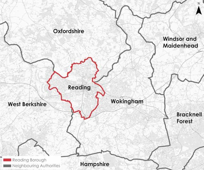
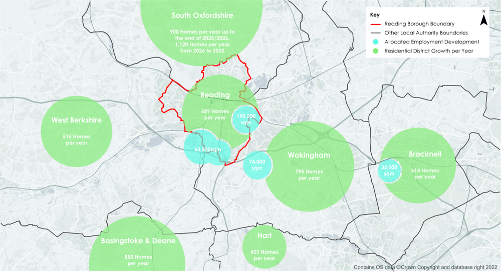
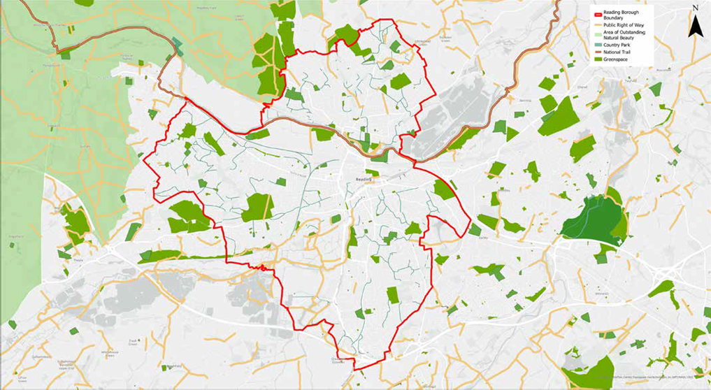
3.1 Reading borough forms the central core of the wider urban area which is generally known as Reading. As such, the borough cannot be viewed in isolation from its wider context. Figure 1 (page 13) shows how the urban area centred on Reading extends beyond the borough boundaries and into West Berkshire and Wokingham. For instance, areas such as Calcot, Purley-on- Thames and parts of Tilehurst are located in West Berkshire, and Woodley and Earley are in Wokingham.
3.2 In a wider sense, the Reading urban area in many ways functions as a single ‘city region’ with the nearby towns of Wokingham and Bracknell. The relationship to South Oxfordshire is different, in that the borough boundary currently forms the edge of the urban area, however there is still a significant level of demand for travelling between the two areas. Whilst Reading is bordered by Wokingham in the south, there are also significant movements between Reading and Hampshire, particularly Basingstoke and Winchester.
3.3 Reading borough itself was estimated to be home to 174,200 people in 2021 (3) and around 233,000 in the greater Reading area. The population is set to rise by a further 1% by 2040 (4). Whilst, in common with most areas, there is an ageing population, Reading nonetheless has a younger population profile than many of its neighbours. Given the urban nature of Reading, it is unsurprising that it ranks fourth in the South East for population density, with 3,969 people per square kilometre (5).
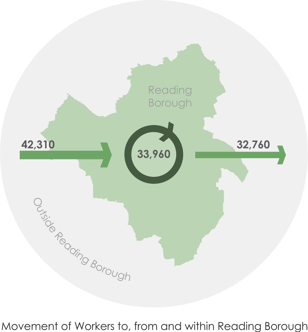
3.4 Reading is a major centre of employment, with approximately 121,000 people working in the borough (6). There are more jobs in Reading than workers (7), which means there is a significant demand for travelling into Reading from other local authority areas, as shown in Figure 3, placing strain on the transport network and impacting the wellbeing of residents within the borough. This reflects the economic success of the town, which functions as the centre of the Thames Valley, one of the most economically dynamic regions in the country.
3.5 Reading is a hub for a variety of businesses, including ICT, professional services and pharmaceuticals. The attraction of Reading is enhanced by a workforce that ranks within the UK top 5 for qualification levels and productivity (8). At the same time, the town also hosts a number of industrial activities, and has an increasing role within the logistics sector. Berkshire has over twice the national average of technology specialists in employment (9). Many of these businesses rely on the high level of skills in the area, and there are strong relationships with the University of Reading and other higher education providers in the area. However, despite the overall economic buoyancy, there are pockets of deprivation within the urban area where there are high levels of unemployment which is a key challenge this strategy seeks to address.
3.6 The centre of Reading is a major retail and leisure destination, with The Oracle ranked in the top 50 shopping centres in the UK (10). Reading is also home to the University of Reading and Reading College. A large percentage of the local working population are highly skilled, ranking as 5th highest amongst 63 sample UK cities for working age population with high level qualifications (11). The University of Reading is renowned for world-class research, particularly in the areas of health, environment and food security.
It also has one of Europe’s leading business schools and a recently established science park.
3.7 Reading ranks highly from an economic perspective; it has the 10th highest employment rate, the highest average weekly earnings and a labour force where 26% of all jobs are within knowledge intensive business service, the highest percentage in the UK (12). Reading significantly benefits from a relationship between the availability of highly skilled workers and a network of highly skilled businesses. The Thames Valley region also has the highest levels of productivity in the UK outside of London (13).
3.8 Reading is a place with huge potential, second only to London for wages; it has above average economic productivity and rates of employment. Despite this economic success, Reading has some of the most deprived neighbourhoods in the whole of the Thames Valley, which are often masked by statistics at borough and even ward levels. High costs of living and housing have contributed to Reading being identified as the 5th least equal city in the UK (14), indicating that many residents are not benefiting from the town’s success. We are committed to reversing this trend and ensuring all residents have the ability to benefit from the town’s success.
3.9 Reading has seen an increase in the number of LSOAs (Lower-layer Super Output Areas) that are within the UK’s most deprived 10%, from none in 2010 (15), to 2 in 2015 (16) and to 5 in 2019 (17). Deprivation statistics consider income, employment, education, barriers to housing and services, health, living environment and crime, many of which are factors that transport either contributes towards or is affected by. The availability, accessibility and affordability of public transport and the provision of walking and cycling facilities are critical to ensuring equality of opportunity and connectivity across the Reading area.
The wider urban area and strategic transport connections
3.10 Reading is situated within a wider area that includes Wokingham and Bracknell which functions as a city region: a densely populated urban area with a regional centre, sub regional hubs, major business/science parks and large suburban areas. This region currently encompasses the existing urban areas and planned development areas, and is expected to expand as additional development is identified at the edge of the existing region.
3.11 The area forms a natural economic cluster which is forecast to be the UK’s second fastest growing economy in the South East between 2022 and 2025. Reading’s economy has already grown by 4% in comparison to 2019 pre-pandemic levels – the biggest increase for any area of the country, and is expected to grow by 3.1% per year until 2025 (18).
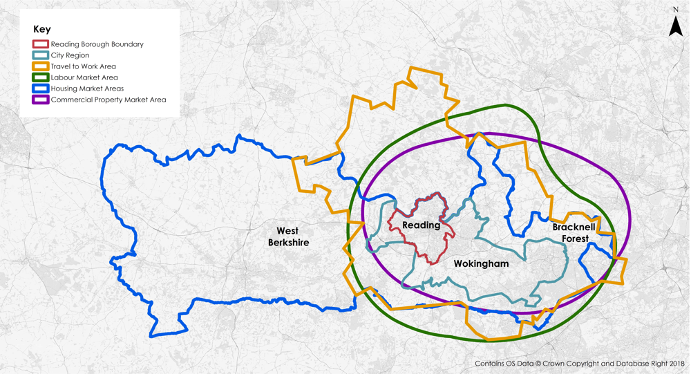
3.12 The region straddles four administrative boundaries over 200 sq. km, sitting at the centre of the Reading travel to work area; and the housing, labour and commercial market areas, shown in Figure 4.
3.13 Reading is the main town within the region and is a major population and employment centre within the South East, with a workday population of 165,005.
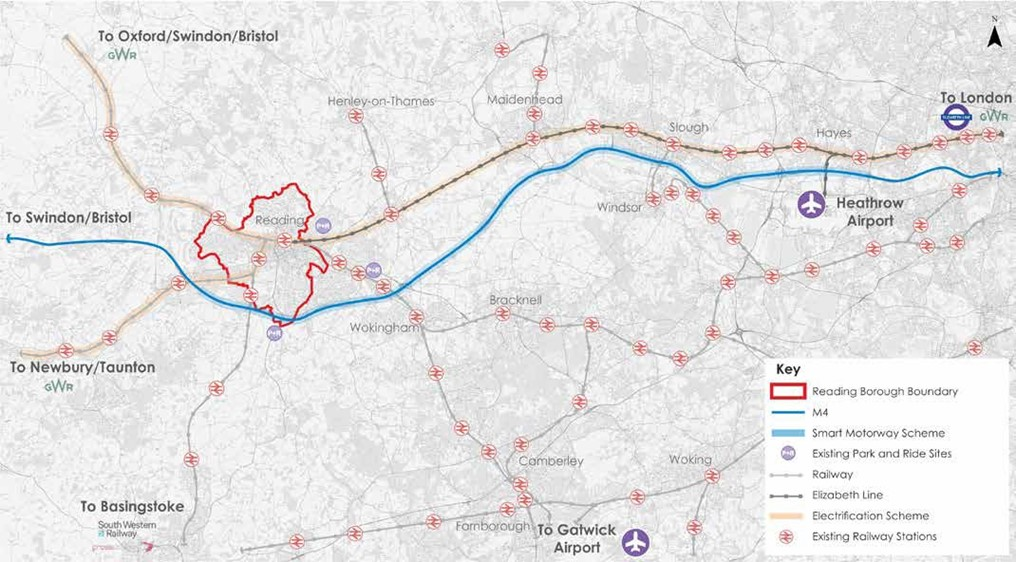
When considering the wider city region, the workday population is 401,824, comprising Reading borough itself, and a further 126,524 people in part of Wokingham borough, 83,753 in part of Bracknell Forest and 26,542 in part of West Berkshire (19).
3.14 Reading’s location on the Great Western Main Line railway and the M4 motorway makes it a major hub for regional and national transport movement. Reading Railway Station is one of the busiest railway stations in the UK outside of London and marks the western extent of the Elizabeth Line. In addition, Reading’s location on the Kennet and Avon Canal and River Thames and at the meeting point of several national cycle routes, connecting to London, Wales and the Isle of Wight via Southampton, gives it significance for a variety of modes of travel.
3.15 Reading benefits from close proximity to London and Heathrow Airport via both road and rail, alongside excellent links to national rail and road networks. There is ongoing significant investment in the national transport network in the area, with schemes coming forward including the Elizabeth Line, the Western Rail Link to Heathrow and railway line electrification.
3.16 The local road network within the area includes the A33, A4 and A329(M) which form part of the national Major Road Network (MRN). These roads are important in Reading, as they provide links to the wider strategic network. In particular, the A33 provides a link between the M3 motorway at Basingstoke to routes north of Reading that connect to the M40 and is therefore used heavily by vehicles travelling long distances.
3.17 Such connectivity is represented by Reading’s status as a regional transport hub, international gateway and a major transport interchange as shown in Figure 5.
3.18 Whilst this excellent access to wider strategic networks provides many advantages to Reading and local residents, it also creates significant demand for travel in to and through the borough. Despite having the third highest bus use in the country Reading remains one of the most congested towns in the UK, with car congestion in the area causing the second highest levels of delays in any local authority outside London (20).
3.19 Reading is the seventh highest ranked city in the UK for inward investment (21), and the fourth most productive (22). Reading was also ranked fourth out of the UK’s top cities for good growth, considering a number of factors including economic performance and transport connectivity (23).
3.20 Economic success and growth in Reading are expected to continue and substantial house building is planned in both Reading and neighbouring authority areas. Major new development is proposed in central Reading, south Reading and at the edges of the Reading urban area within neighbouring Wokingham, West Berkshire and South Oxfordshire authorities, as well as in Bracknell Forest further east.
3.21 Between 2013 and 2036, Reading’s Local Plan commits to the delivery of 15,847 homes – an average of 689 per year. Accounting for adopted and emerging Local Plans for neighbouring Local Authorities, this increases to a total requirement of approximately 2,600 homes per year across the city region. Figure 6 shows the planned annual increase in housing numbers in Reading and surrounding Local Authorities (24).
3.22 The need to manage the increased demand this growth will have on the local transport network and mitigate the potential negative impacts for local residents is a significant challenge that this strategy seeks to address. We will do this by providing a high-quality, efficient and connected transport network that prioritises walking, cycling and public transport trips to manage the additional forecast trips. It will be important to encourage sustainable travel to manage growth by providing high-quality alternatives to the private car.
Environmental considerations
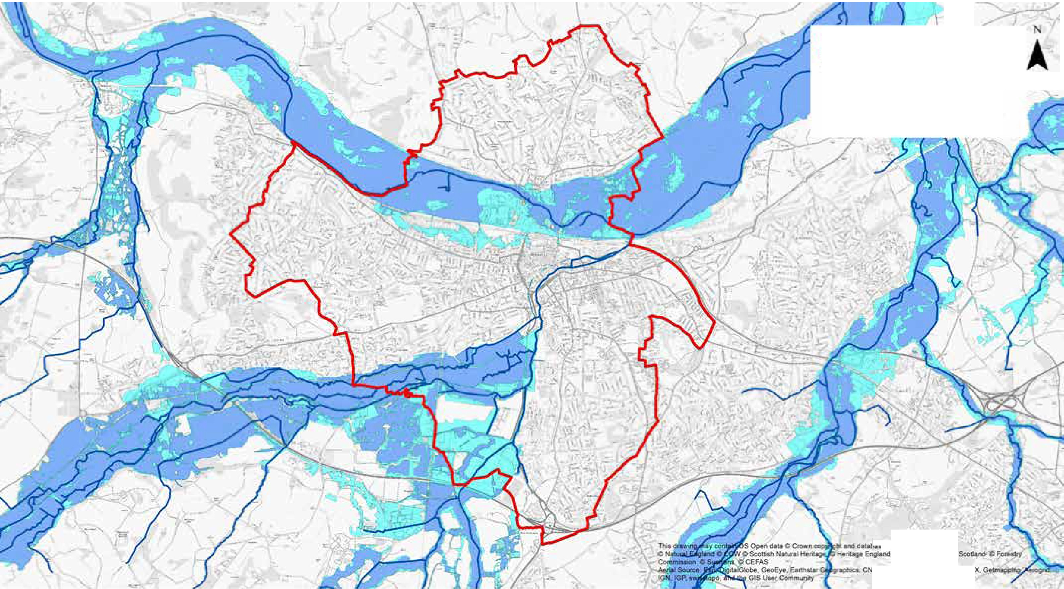
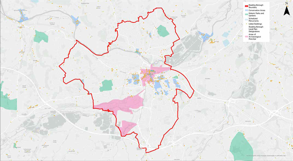
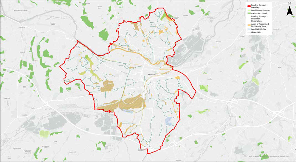
3.23 Across Reading, there are environmental constraints that will influence where we deliver our schemes, and how they are designed, particularly where these constraints are significant or concentrated. Figures 7 to 10 show the flood risk, heritage, ecology and landscape constraints within and surrounding the borough. These constraints will be taken into account in the development and delivery of all physical infrastructure schemes, which will also be supported by relevant technical information and assessments.
Current travel in Reading and the wider urban area
Walking and cycling
3.24 Walking on its own is not only a trip mode choice but walking forms a part of almost all journeys taken by other means of travel. This is as people travel to and between their homes or work places and car parks, bus stops, railway stations or other interchanges.
3.25 Walking and cycling also offer health benefits, both in terms of the physical benefits of active travel and through increasing opportunities for social engagement. There is clear evidence that the environment in which people live has a significant impact on health and wellbeing. It has both direct health benefits, and an impact on people’s attitudes, behaviours and perceptions of their environment. For instance, reducing air pollution can improve perceptions of safety and promote outdoor physical activity and social interaction (25).
3.26 It has also been demonstrated that good neighbourhood design (in terms of walkability and mixed land use) has positive impacts on health and wellbeing, through increasing opportunities for social interaction and active travel, and helping to promote healthy behaviours (26). Neighbourhood and street layouts should be designed to allow for pedestrian and cycle connections within and between neighbourhoods, encouraging healthy lifestyles (27). Physical activity, such as walking and cycling, has been shown to improve mental health, particularly in terms of self-esteem, mood and depression, as well as dementia (28).
3.27 Mental health issues are common in the UK, with approximately 33% of people experiencing a mental health problem each year (29).
3.28 Creating an attractive environment where people feel safe to walk and cycle has the potential to lead to many positive health outcomes. Benefits include increased mobility, physical activity levels, greater social interaction, reduced BMI and reduced risk of injury. We can achieve this through delivering improved infrastructure prioritising pedestrians and cyclists, such as segregated facilities, traffic calming measures, and public space improvements.
3.29 The provision of open and green space, high quality public transport and improved air quality have been demonstrated to lead to increased physical activity, improved cardiovascular outcomes, and increased social interaction, among other health benefits (30).
3.30 Additionally, provision of access to green open spaces and recreational activities by sustainable means will be an important consideration.
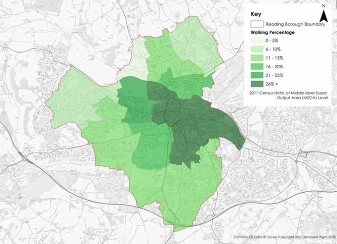
3.31 A large proportion of people in Reading walk to and from work, as shown in Figure 11, however, there is scope to increase the number of walking and cycling trips. Our Local Cycling and Walking Infrastructure Plan (LCWIP) sets out how we will increase the number of walking and cycling trips into the town centre within a 2km and 10km radius respectively. Additionally, our Rights of Way Improvement Plan (ROWIP) sets out how we will maintain and improve our rights of way network, with an overall objective of encouraging more people to choose walking and cycling for local journeys, or as part of longer multi-modal journeys. There is also scope to increase trips within local or adjoining areas such as those made to local facilities and services including local centres, schools, healthcare, leisure centres and libraries.
3.32 Many measures for the promotion of active travel and its health benefits were delivered during the Covid-19 pandemic. We want to build on this and encourage people to make long term sustainable travel choices with less reliance on the private car. This will provide benefits for the environment such as a more pleasant walking space, alongside health benefits of cleaner air.
3.33 Cycling levels in Reading are slightly above the national average. However, other urban areas, such as those who have been provided significant central government funding through the Cycling Ambition Cities programme, have demonstrated the significant potential of increasing cycling mode share when supported by significant investment. In addition, there is significant opportunity to increase commuter cycling trips from the wider urban area due to the compact and relatively flat nature of much of the town, and build on the increased level of cycling that occurred during the Covid-19 pandemic.
3.34 Whilst there is a good network of radial cycle routes within Reading, there are limited orbital connections and some areas are not connected via any dedicated cycle routes. In the wider city region, the new National Cycle Network route (NCN 422) links Newbury to Ascot via Reading, Wokingham and Bracknell; however further cycle improvements are needed to better connect the wider city-region and suburban areas, including proposed development sites. Cars dominate key corridors into and out of Reading making both walking and cycling less attractive due to poor air quality and limiting the space available to provide for sustainable travel. Investment has been made in walking and cycling schemes to improve local connectivity within the town, as well as strategic connections across the city region.
Public transport – rail
3.35 Existing rail lines runs east-west and north- south through Reading, with frequent services from Reading Station providing fast links to London, the West, Wales, South West, South Coast, Gatwick Airport, the Midlands and North of England. Interchange at Hayes Station currently provides rail access to Heathrow Airport from Reading.
3.36 Reading Station is the UK’s 9th busiest railway station outside London. Passenger numbers are recovering following the Covid-19 pandemic, and pre-pandemic catered for around 17 million passengers (and a further 4 million interchanging passengers) every year, with passenger numbers increasing annually (31). The upgrade of Reading Station, completed in 2015, has relieved previous capacity constraints and allowed us to secure ongoing sustainable economic growth in Reading, providing further redevelopment opportunities.
3.37 The Elizabeth Line opened in May 2022, with services initially running between Reading and London Paddington. Since November 2022, direct services are operational between Reading, through Central London and across to the east side of London.
3.38 Reading is planned to further benefit from significant investment in the following strategic rail schemes:
- The Western Rail Link to Heathrow will provide direct access to Heathrow Airport from Reading
- The high speed rail line (HS2) will reduce journey times from London to the Midlands and the North via an interchange on the Reading to Paddington line at Old Oak Common, enhancing connections from Reading to the rest of the UK. The first section is planned to open between 2029 and 2033.
Public transport – bus
3.39 We have supported investment in buses for a number of years, including through delivery of bus priority and dedicated infrastructure, for example at the M4 junction 11, along the A33 and at Park and Ride facilities, at Mereoak and Winnersh Triangle. This investment has been further reinforced with significant investment from Reading Borough Council, owned Reading Buses in prioritised customer service, new technologies and environmentally friendly vehicles.
3.40 Reading Buses offer free Wi-Fi, on-board charging for mobile devices, smart ticketing, real-time rail information on buses that link with Reading Station, audio and visual displays and GPS tracking for real-time information. Reading Buses reported a 48% increase in bus use since 2009, when it started sharing open data, and in 2018 (32).
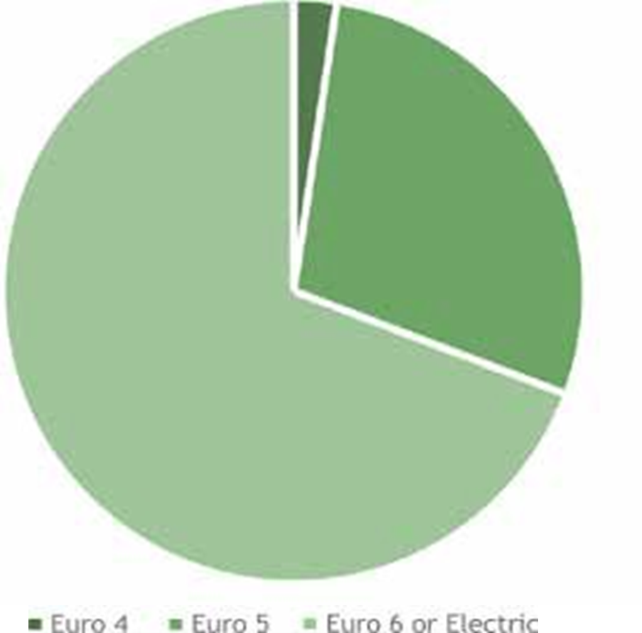
3.41 Reading Buses has one of the most environmentally friendly fleets in the country, with 85% of the fleet are hybrid, gas powered, or meet Euro 6 emissions standards (33, 34).
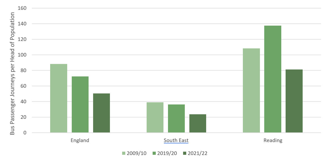
3.42 Bus use per head of population in Reading increased by 27% between 2009 and 2019 (35). This has been against a backdrop of national decline (-18% across England), and a decline of 7% in the South East overall, as shown in Figure 15. Few places have similarly bucked the long-term trend of decline in bus use. Whilst bus use declined significantly in Reading and across the rest of the UK during the pandemic, trip numbers are now recovering, and Reading has the third highest level of bus use in the country outside London.
3.43 Whilst Reading benefits from frequent, high quality bus services delivered by one of the most successful bus companies in the UK, and supported by Reading Borough Council, neighbouring areas of the South East are not so fortunate. Services in out-of-town areas are prone to delays on the road network from car congestion due to high car usage and resulting in lower levels of bus passenger journeys per head of population for commuter trips travelling to Reading from outside of the borough.
3.44 Some neighbouring areas have amongst the lowest bus use figures nationally and therefore a large proportion of people travel from these areas into Reading by car.

Road
3.45 The M4 motorway runs east to west just south of Reading, with three junctions offering access to the city region. The M4 Junctions 3 to 12 Smart Motorway scheme, completed in 2022, has increased capacity on this road.
3.46 There has been a huge shift in the town’s economy, from its origins in ‘beer, biscuits and bulbs’, to a compact service economy which specialises in business and insurance services, home to the largest concentration of information and technology corporations in the UK. The Thames Valley generates some £45.8 billion per annum in output (36) and is the most productive area in the UK in regard to GVA per hour worked (37).
3.47 A high proportion of people in the wider city region continue to drive to and from work and schools, with the average annual delay to drivers in Reading more than twice England’s average (38). Pre-pandemic, the average car commuter in Reading spent 35 hours a year in congestion during peak hours.
3.48 Reading car commute times increased by 46% between 2007 and 2016 (39) and a survey undertaken by RBC showed that 93% of local businesses that responded believe congestion affects productivity (40). Whilst congestion has subsequently decreased during the pandemic, they are now increasing and causing air quality and productivity issues.
3.49 Reading’s road network can become crippled when incidents or closures occur on the M4, or other major roads into/out of the town centre. It is vital that National Highways continue to build resilience into the strategic road network to enable the transport system to continue to operate efficiently during such periods of disruption as the town continues to thrive and grow.
3.50 The ability to continue to attract inward investment while reducing environmental impacts in Reading depends on managing the transport network and providing sustainable transport facilities as demand for travel grows. This will require sustained investment across the transport network so that Reading and the Thames Valley area can continue to thrive.
Building on our success
3.51 We have made significant investment in the transport network in recent years. During this time, significant levels of investment have been secured to provide new and upgraded transport infrastructure and encourage people living, visiting and working in Reading to use sustainable transport options.
3.52 We have an excellent track record of successfully securing external funding to deliver improvements to the transport network in Reading. This includes over £25 million from the Department for Transport’s Local Sustainable Transport Fund, which enabled us to deliver a programme of sustainable schemes including Christchurch Bridge, and Mereoak and Winnersh Triangle Park and Rides sites; over £40 million from the Thames Valley Berkshire Local Enterprise Partnership to help deliver a new railway station at Green Park, and initial phases of the South Reading Bus Rapid Transit corridor scheme, Thames Valley Park and Ride (in partnership with Wokingham Borough Council), upgrades to Reading West Station and Theale Station (in partnership with West Berkshire Council), and a new cross-Berkshire National Cycle Network route.
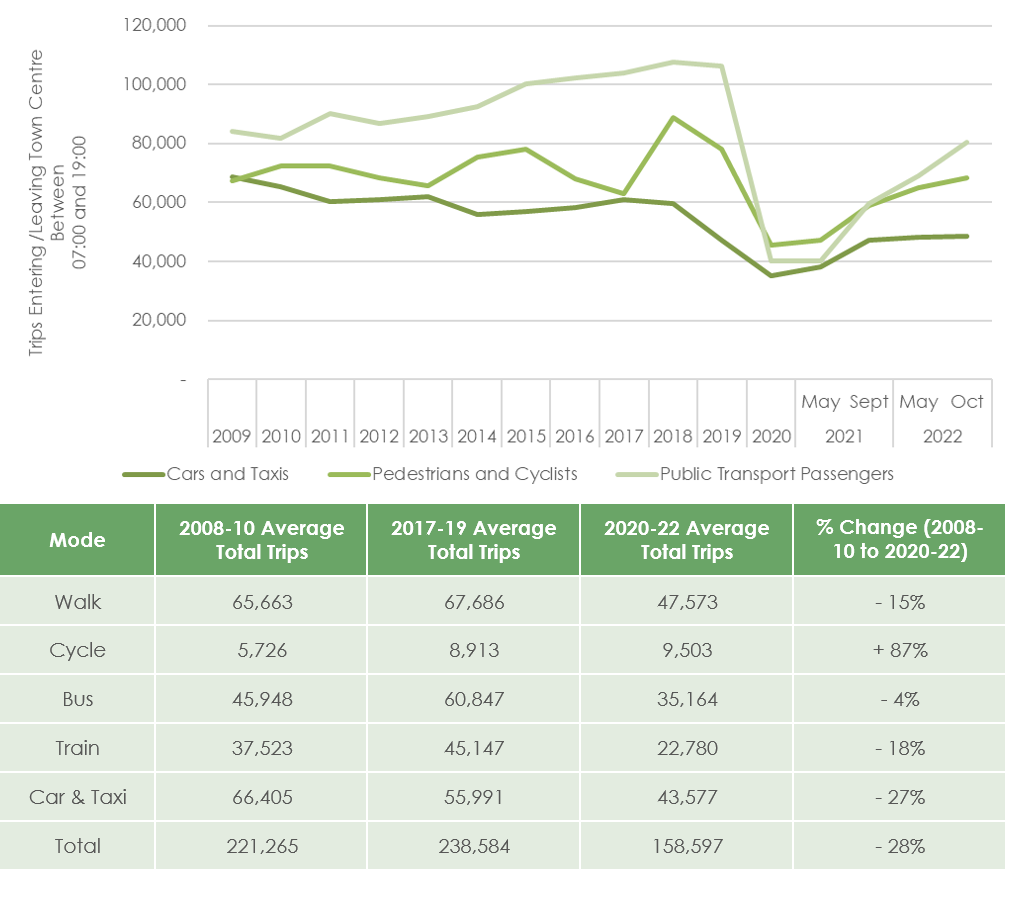
3.53 Reading has been at the forefront of delivering innovative technology schemes including the recent Smart City Clusters and ADEPT Live Lab projects. Reading has also been involved in EU- funded projects researching the application of sustainable transport initiatives and sharing best practice.
3.54 Progress in delivering our transport strategy objectives has been monitored annually since 2008 through our cordon counts, where we conduct a 12-hour survey of trips made into and out of the town centre by each mode of travel. The historical data, as shown in Figure 16, is a useful indicator that, prior to the Covid-19 pandemic, there had been an overall increase in the number of trips being made into and from the town centre and a continuing upward trend in sustainable transport trips against a decline in car trips.
3.55 This connectivity and economic success creates significant demand for travel, however due to our investment in sustainable travel options there are high levels of public transport, walking, and cycling use in the borough. Travel patterns have now stabilised following the uncertainty created by the Covid-19 pandemic, with the number of trips undertaken recovering but appearing to plateau at levels below those seen pre-Covid. There are however some differences emerging in travel patterns, with the afternoon peak occurring earlier than pre-Covid and changes in journey purpose with fewer being made for work and more for deliveries and leisure purposes when compared to pre-Covid levels. Overall, whilst levels of general traffic still remain high in the borough, there have been increases in sustainable travel usage which appears to show that changes adopted during the pandemic are likely to have become long-term travel behaviours for some people.
Engagement and Initiatives
3.56 In addition to numerous major projects that we have delivered in recent years (such as those shown in case studies on the following pages), we have also delivered a wide range of initiatives and engagement activities.
3.57 These include air quality measures, such as the installation of ‘No Idling’ signage at schools, expansion of the Co-Wheels car club in Reading, and a significant Transport Strategy Visioning Consultation, Public Exhibition programme of residential and business personalised travel planning.
3.58 As part of our school travel strategy, we have engaged with schools across Reading to encourage uptake of various initiatives including road safety education, Bikeability cycle training, the national school sustainable travel accreditation scheme Modeshift STARS, Living Streets’ Walk on Wednesday (WOW) programme, and School Streets.
3.59 We have delivered many significant active travel schemes including Christchurch Bridge and National Cycle Network route 422, alongside a comprehensive programme of local improvements such as numerous new pedestrian and cycle crossing facilities, additional cycle parking at Reading Station, Reading town centre and local centres throughout the urban area, School Streets and cycle training, road safety education and school and personalised travel planning initiatives.
Active Travel
Recently delivered schemes include:
- Christchurch Bridge
- Reading Station Cycle Hub
- National Cycle Network 422
- London Road Active Travel Improvement Scheme
- Forbury Retail Park to Napier Road Active Travel Link
- Church Street Public Space Enhancements
- Active Travel Fund schemes
- School Streets
3.60 Much-needed repairs to walking and cycling links in the town have also been carried out, such as the St Laurence’s Church wall at the Forbury, where the structural buttresses supporting the wall had blocked the footway since the 1970s. We also refurbished and reopened an underpass under the Great Western Main Line connecting Newtown to the River Thames, reducing severance for residents in the area.
3.61 As part of the Emergency Active Travel Fund, various schemes, including a two-way segregated cycle route on Sidmouth Street, have been implemented across Reading with the aim of supporting social distancing and encouraging active travel. A number of these schemes have reallocated road space from the private car to walking and cycling.
3.62 Public transport has been a key focus for Reading over recent years, and we have delivered several major schemes, including major upgrades to Reading Station and delivery of parts of our South Bus Rapid Transit (BRT) corridor. In addition, we have carried out a replacement programme for old bus shelters and implemented Park and Ride services from Mereoak Park and Ride to the Royal Berkshire Hospital, Green Park and Reading football matches.
Case studies – Active Travel
Project name: Christchurch Bridge
Cost: £5.9 million
Status: Completed 2015
Christchurch Bridge was opened in 2015, providing a step-change in pedestrian and cycle provision between Caversham and Reading railway station and town centre, reducing the severance caused by the River Thames and helping to encourage active travel. The bridge also enhances access to green space at Christchurch Meadows for residents in the town centre. It was the first new crossing of the Thames in Reading for almost 90 years.
Determining key geometric requirements of the bridge required careful development with attention to architectural concept, build-ability and environmental elements. The design incorporates extensive new landscaping, including an area of wetland habitat to achieve flood mitigation and enhance biodiversity, while managing constraints including proximity to adjacent properties. Christchurch Bridge provides a legacy for future generations. The bridge is the first across the River Thames built outside London for 20 years.
Project name: NCN 322
Cost: £4.2 million (across Berkshire)
Status: Completed 2020
The new National Cycle Network Route 422 will connect Newbury and Ascot, via Reading, Wokingham and Bracknell. The scheme provides better connections for long distance cycle journeys, as well as enhanced facilities for more local journeys within Reading. The section within Reading links to those in neighbouring authorities serving major business parks, local centres, Royal Berkshire Hospital, the University of Reading and schools.
Enhancements include both on and off- carriageway cycle facilities, new crossing points including raised tables and tiger crossings to improve connectivity along the Bath Road, through the town centre and along Wokingham Road.
Project name: School Streets
Cost: approximately £20k per scheme
Partners: schools and colleges
School Streets create a safer and healthier environment for everyone, including local residents. The initiative is part of the Council’s wider ambitions for encouraging more active travel, such as cycling and walking, and as a result support better physical and mental health, lower carbon generation and improved air quality.
The running of school streets in the borough is both led and organised by schools themselves, with support and guidance provided by the Council.
Reading now has 4 school streets incorporating 6 schools with a scheme at Park Lane Junior in Tilehurst, Wilson Primary School off the Oxford Road, Thameside Primary School in Caversham and at Crescent Road covering Maiden Erlegh School, Alfred Sutton Primary and UTC Reading.
Project name: Shinfield Road Active Travel Scheme (under construction)
Cost: £1.3 million
Partners: University of Reading, Active Travel England
Work commenced in 2022 on our Shinfield Road Active Travel Scheme which will see the delivery of a new cycle route along Shinfield Road between Christchurch Green and Shinfield Rise. This new segregated cycle scheme will link south Reading and the Royal Berkshire Hospital, the University of Reading, local centres and Reading Town Centre. It links with existing new cycle routes delivered by the Council on Redlands Road and Christchurch Road in the first stage of its Active Travel programme.
The improvements include the provision of no waiting restrictions (double yellow lines) on Shinfield Road along the route, to address the parking issues being experienced particularly near the University.
New advanced stop lines and early release for cyclists are also provided to improve safety as well as a number of new and improved crossings for pedestrians which also form a key element of the scheme.
Public transport
Recently delivered schemes include:
- Reading Station Upgrade
- Reading Station Interchanges
- Reading Station Town Centre Enabling
- Cemetery Junction Bus Priority
- Winnersh Park and Ride
- Mereoak Park and Ride
- South Reading BRT Initial Phases
3.63 The delivery of bus priority measures in Central Reading and along routes leading out of the centre have helped keep bus services out of congestion, contributing to the significant rises in bus use mentioned earlier.
3.64 We have successfully campaigned for the Elizabeth Line to be extended from Maidenhead to Reading, to provide a direct route from Reading across London. TfL Rail services between Reading and Paddington began from December 2019 with four trains an hour (six per hour at peak times) running between Reading and Paddington. With the formal opening of the Elizabeth Line in May 2022, frequencies increased to up to 12 trains per hour and, following the completion of the route in November 2022, passengers can now travel through Central London all the way to Canary Wharf and Abbey Wood without changing. The Elizabeth line services also radically improve the local train services within the Thames Valley by providing more regular trains linking Slough, Maidenhead and Twyford to Reading.
3.65 We have also delivered a new station at Green Park, and improvements to Reading West station, both of which were completed in Spring 2023.
3.66 In 2015, we opened Mereoak Park and Ride near the M4 11, which was shortly followed by the opening of Winnersh Triangle Park and Ride two months later. Combined with Madejski Park and Ride, the facilities have provided a cost-effective alternative to private car travel into the centre of Reading. All three sites are served by regular bus services, with Mereoak and Madejski also benefiting from the South BRT corridor.
3.67 Reading has grown significantly over the last few years, with advances made both in the provision of information (through Variable Message Signs and mobile applications, for example) and through data collection such as the Bluetooth journey-time monitoring system.
3.68 Detection infrastructure has been installed at disabled parking bays in Reading, facilitating development of a mobile application that can be used to remotely determine whether disabled parking is available.
Case studies – public transport
Project name: Reading Station Area
Cost: £879 million
Status: Completed 2015
Partners: Network Rail
Reading Railway Station underwent a major upgrade, which was completed in 2015.
The works included provision of a new North interchange and remodelling of the southern interchanges to improve public space and enhancing the connectivity and legibility of the area. New platforms were built, along with track layout reconfiguration to remove bottlenecks on the Great Western Main Line and a new rail signalling centre for the Thames Valley. Major work was also carried out on the Great Western Main Line to prepare for electrification.
The works have led to a 125% improvement to through line platform capacity, and a 38% improvement in service performance (41). The new station has been designed to accommodate the Elizabeth Line and Western rail access to Heathrow Airport.
The revitalisation of Reading Station has been a catalyst for major redevelopment in Reading as a whole, including Station Hill and Thames Tower.
Project name: South Reading Bus Rapid Transit
Cost: £18.3 million (to date)
Status: In progress
Partners: Reading Buses, Wokingham Borough Council, Thames Valley Berkshire Local Enterprise Partnership, Green Park, Reading International Business Park
Reading’s South Bus Rapid Transit (BRT) corridor scheme has delivered a series of bus priority measures on the A33 between Reading Town Centre and the Mereoak Park and Ride facility to the south of the M4 junction 11. The scheme is designed to reduce forecast congestion and improve public transport journey times and reliability on this key corridor into Reading, helping to accommodate the increasing travel demands associated with economic growth and development by attracting more travel to be made by public transport instead of private car. We have a phased approach to implementation of South BRT, delivering sections of the scheme as external funding is secured.
Journey times for South BRT services have reduced by up to 24% from 2015 when Mereoak was opened and these services are now the most reliable in the Reading area. As a result of this improvement, average passenger numbers on these services have increased by 62% from 2015 to 2019.
Project name: Green Park Station
Cost: £24 million
Status: Completed 2023
Partners: Network Rail, Great Western Railway, Thames Valley Berkshire Local Enterprise Partnership, Department for Transport
Reading Green Park Station is a new railway station in south Reading, located on the Reading to Basingstoke line. A half-hourly service operates at the station, north to Reading Central and south to Basingstoke.
The new station building is fully accessible, and facilities include a new overbridge with stairs and lift. A multi-modal interchange is provided, including bus interchange, decked Park and Ride facility, short stay car park (Kiss and Ride), taxi drop-off, disabled parking facilities, access road, and landscaping.
The station acts as an integrated transport hub for southern Reading, linking surrounding residential areas and major business parks to the railway network and improving access to sustainable transport, including linkages to the South Reading BRT route.
Green Park is one of the largest employment areas in central Berkshire and offers significant opportunity for growth. The station helps to alleviate congestion in the area and along the A33 corridor, helping to unlock growth at the business park, and also directly unlocking residential development at the adjacent Green Park Village.
Construction of the station began in Spring 2019, and the station opened with the first public services on Saturday 27th May 2023, which marked the town’s first new railway station since the opening of Reading West Station in 1906.
Highway, network management and parking
Recently delivered schemes include:
- Cow Lane Bridges
- Red Route
- A33 Pinch Point Scheme
- Electric Vehicle Charging Infrastructure
- Eastern Area 20mph
- Traffic Signal Upgrades
- Reading Bridge Strengthening
3.69 Traffic signal upgrades have also been carried out across the majority of traffic signal junctions across the borough, replacing life expired equipment, installing new low energy equipment and improving the network’s ability to respond dynamically to changing traffic flow and pedestrian and cycle movements at crossings.
3.70 Reading’s transport systems produce a significant amount of data, therefore making best use of this data to optimise the network for all users has been a key priority. This included the securing of DfT funding to apply machine learning to the datasets to not only understand the current operation of the network, but to also predict the near-term future to enhance how Reading deals with congestion, incidents and events.
3. 71 Several highway and parking schemes have been delivered within the borough, including safety schemes, schemes to improve public space, and increases to highway capacity. 20mph speed limits have been implemented around primary schools, as well as waiting restrictions and yellow zigzags, and verge and footway parking bans have been implemented in Tilehurst and Southcote. Mobile payment facilities for on-street pay and display parking have also been installed, alongside residents’ parking schemes in many areas.
Case studies – Highway, network management and parking
Project name: Cow Lane Bridges
Cost: Included in Reading Station Area works
Status: Completed 2019
Partners: Network Rail
Improvement works to the Cow Lane Bridges were completed in 2019, improving travel around Oxford Road and Portman Road. This major upgrade to the bridges has been delivered to enable two-way traffic through both bridges, thus removing a major traffic bottleneck within Reading.
The scheme can also accommodate larger vehicles such as buses and lorries. This provides the opportunity to route lorry traffic in the West of Reading away from the Oxford Road, creating a potentially safer and more welcoming environment for residents and businesses in the local area.
An enhanced walk and cycle route has been provided as part the scheme along Cow Lane.
Project name: Red Route
Cost: £250,000
Status: Completed 2019
A Red Route has been implemented in Reading on the 17 bus route along the Oxford Road, through the town centre and along Wokingham Road. This is a no stopping restriction which will keep key public transport services moving, prevent delays for bus passengers and improve safety for pedestrians and cyclists.
There are over 4.5 million trips on the 17 bus route each year (42), and so the Red Route has provided wide-scale benefit to local residents by improving traffic flow and making public transport more reliable.
This initiative is intended to be rolled out to other locations across the town where enhanced enforcement will provide similar benefits.
Challenges and opportunities
Introduction
4.1 To achieve our overall vision for transport in Reading we have identified the issues currently faced in terms of transport, and future challenges and opportunities that this strategy will need to address, to inform our objectives, schemes and policies.
4.2 We have considered:
- Current travel patterns
- Existing transport infrastructure
- Socio-economics and demographics
- Health, wellbeing and environmental issues
- Mitigation of climate change impacts
- Adaptation to climate change
- Future development and growth
- Impact of Covid-19
4.3 This chapter provides details of the key challenges and opportunities for transport in Reading and considers the whole of Reading borough, as well as the wider urban area, including parts of Tilehurst and Purley, Calcot, Woodley, Earley and Winnersh, to allow consideration of cross-boundary issues. Our analysis has considered Reading borough at a strategic level, as well as local issues.
Key challenges
4.4 Seven key challenges for our strategy to address have been identified through detailed analysis of the evidence base. These are:
- Adapting to the future
- Improving air quality
- Reducing car congestion and the negative effects it causes
- Providing affordable and accessible travel for all
- Removing barriers to healthy lifestyles
- Achieving good accessibility to local facilities and employment
- Accommodating development and delivering the Local Plan
Adapting to the future
We know that we are in the midst of a climate crisis. This, alongside fast changing technological innovation, means the future is uncertain and Reading will need to adapt, through both decarbonisation and accepting the need to travel more sustainably. This will affect the way we travel and transport goods, whilst at the same time provide new and innovative opportunities for society.
Our transport strategy will need to enable Reading to not only adapt to the challenges of the future, but also to drive us towards the sustainable future in our vision. This will include facilitating changing travel patterns and behaviour, shifting more travel of both people and goods to sustainable modes and also ensuring Reading maximises the opportunities that emerging or currently unknown technologies will allow.
Climate emergency crisis
4.5 We are in a state of crisis with our actions to date having increased atmospheric CO2 levels to a level where average global temperatures will rise to around 1.5 to 2.0 degrees above pre-industrial base by around 2050. There are significant risks of temperatures rising further.
4.6 The impacts of climate change will affect us all. Flood events are expected to become both more severe and more common, damaging infrastructure, including the transport network, and buildings. Droughts will also become more common, and food may become more difficult to grow. Power and water supplies are very likely to be disrupted (43).
4.7 Transport is the biggest sector in terms of CO2 emissions in the UK (44) representing nearly a quarter of emissions. Whilst transport emissions reduced significantly during the Covid-19 pandemic due to restrictions on travel, more recent data indicates that emissions post the lifting of restrictions are expected to have increased back to near pre-pandemic levels.
4.8 The very modest technological improvements in petrol and diesel engine technology over the last 20 years to reduce CO2 have been more than offset by consumer behaviour changes, which include a large and rapid increase in SUV sales and a move to internet shopping, leading to a large increase in delivery vans. Globally, the growth in SUV sales is the second highest cause of continuing increases in atmospheric CO2 after power generation (45).
4.9 The government’s targets for net zero by 2050 and a need to more than half CO2 emissions globally by 2030 as set out by the Commission for Climate Change require radical action. This cannot be achieved through only technological intervention; people will need to make changes to the way they live their lives and how they travel.
4.10 By 2030, the sale of new ICE (Internal Combustion Engine) cars and vans will be banned in the UK, with some hybrid cars able to be sold to 2035. ICE HGVs are to be banned by 2040. Car manufacturers are expected to reduce outputs of combustion engine cars in advance of this, and by 2030, 70% of new cars are likely to be electric (46).
As older cars are gradually replaced and removed from the network, fewer and fewer ICE vehicles are expected to remain on our roads, although we could still have large numbers on the roads in the 2030s.
4.11 Even with zero emission vehicles, we will need to substantially reduce how much we travel by private car over the period of this strategy; the manufacturing processes for electric vehicles and (at least currently) the sources used for electricity generation to power them both result in air pollution that contributes towards climate change. Additionally, electric vehicles produce particulate pollution as they are used, and both electric and combustion engine vehicles add to congestion and reduced levels of physical activity.
The Green Industrial Revolution
4.12 Previous industrial revolutions have fundamentally transformed global economies and the way we live, as shown below. The Industrial Revolution brought steam power and mechanical production, with the Technological Revolution bringing electricity and mass production. The most recent industrial revolution – the Digital Revolution – brought electronics, IT and automated production. We are now on the cusp of a fourth industrial revolution: the Green Industrial Revolution. This will be shaped by the need for a cleaner and greener future to meet the global climate challenge and deliver both economic growth and carbon net-zero, in world with rapidly advancing technologies, such as cyber-physical systems and artificial intelligence.
4.13 The UK government’s 10 Point Plan for a Green Industrial Revolution lays the foundations for the industrial revolution:
- Advancing offshore wind
- Driving the growth of low carbon hydrogen
- Delivering new and advanced nuclear power
- Accelerating the shift to zero emissions vehicles
- Green public transport, walking and cycling
- Jet zero and green ships
- Greener buildings
- Investing in carbon capture, usage and storage
- Protecting our natural environment
- Green finance and innovation
4.14 This highlights that we cannot meet our transport challenges of the future through just working within our transport silo but need an integrated smart city approach to delivering services.
4.15 There are a range of new technologies that are fusing the physical, digital and biological worlds, impacting all disciplines, economies and industries, and even challenging ideas about what it means to be human (47).
4.16 Being able to capture the benefits of rapidly changing technology is key to meeting future challenges including climate change and there is huge opportunity from new technologies. However, with such rapid change comes real risks of communities being left behind and risks of a technology led future that is not inclusive, which does not benefit society as a whole.
4.17 The Berkshire Local Industrial Strategy details plans for enabling growth in the region, supporting the UK Industrial Strategy.
Main technological changes
4.18 There are a number of technological changes that are foreseen in the transport sector, as outlined in the following sections.
New fuels
4.19 Public transport, both rail and road has already invested heavily in moving away from use of diesel as a main fuel with electric trains and biogas buses already providing much of Reading’s public transport. Significant investment is now also being made by the car industry in electric vehicle technology (EVs). Hydrogen fuel cell technology is also being developed and we may see this coming forward in this period, probably for freight and potentially public transport in the first instance.
These technologies will help further de- carbonisation the transport sector, although their impact may not be significant before 2040.
4.20 There is a challenge of providing the right balance of public electric car charging infrastructure to support EV take up, whilst not necessitating expensive electricity grid reinforcement and battery storage that may not be required in the long run.
Autonomous vehicles
4.21 There is significant investment and publicity around autonomous vehicles, and we see two distinct applications.
4.22 The first is a private autonomous car that can give hands-free travel to anywhere in the UK. There is not forecast to be a significant take up in the plan period, however in the longer term, autonomous vehicles have the potential to smooth traffic flow, almost eliminate accidents and could free up car parks for development and the continuing development of driver assist systems will contribute to these outcomes in the interim.
4.23 The second is shared autonomous vehicles such as 12- to 15-person autonomous electric pods, although these could be any size of vehicle. These vehicles are already operating at certain locations across the world where they mainly operate in private controlled environments such as business parks. A number of cities globally have trialled these vehicles on-street with traffic. It is anticipated that government legislation will enable autonomous vehicles to operate without a driver in the vehicle on the public highway in the next few years and hence they could form part of a transport strategy for Reading within the plan period. Shared Autonomous Vehicles have the potential to support public transport services, providing affordable door-to-door public transport when connected to interchanges with other public transport services. The ability to connect door-to- door could also provide an inclusive service reducing the need for households to own a car.
Drone delivery
4.24 By 2030, between 150,000 and 400,000 commercial drones are expected to be in operation in the UK (48). There could be drones supporting our emergency services, delivering parcels, as well as supporting other industries. Whilst drones are predicted to uplift the UK GDP by £42 billion by 2030 (49), there are concerns regarding privacy, noise pollution and visual impacts which have yet to be addressed. However, the evidence suggests that drones are likely to be part of our future transport system.
Mobility services on demand
4.25 Mobility services are widely forecast to provide a ‘step-change’ in the way we will travel in the future. Instead of individuals investing in a car which is only in actual use around 4% or 5% of the time (50) they would pay a monthly subscription for a service that can be tailored to their needs which can be accessed via an app and a single payment platform.
4.26 Mobility services can bring together public transport, cycle hire, shared taxi hire and micro-mobility options, as well as private car hire and, by reducing car ownership, can significantly reduce private car dependence, which is critical to enabling economic growth in a net zero carbon future.
4.27 Currently, mobility services are generally an app which brings together journey planning and payment services on a single platform, rather than being an integrated service that will get you from A to B. However, it is expected that these services will harness the power of big data and artificial intelligence to accurately predict demand for travel and hence provide very efficient shared transport services which will remove the need and desire to own a car.
Micro-mobility
4.28 Micro-mobility encompasses a range of transport choices from scooters and bikes (both electric and conventional) to small electric one- and two seat cars for urban transport.
4.29 Some of these, such as e-scooters will require legislation to be legal on the public roads, and others, such as e-bikes need careful consideration in designing routes as they can move at a steady 15mph with very little effort, opening up cycling to a larger section of the population and increasing the areas within easy cycle distance where safe routes are provided.
Next generation of network management systems
4.30 Whilst there have been some key developments, the current traffic management systems are essentially still based on technology from the 1970s and optimise the highway network for vehicles based on monitoring traffic flow. It is anticipated that new generation of network management systems will be delivered, which use multiple sensors (Internet of Things – IoT) including connected vehicles and the travellers themselves to create predictive network models using machine learning and artificial intelligence. This expected to link to mobility services creating a fully multi-modal and integrated system that optimises for the movement of people and not just vehicles.
Wider changes in society – sharing and circular economy
4.31 The sharing economy is another potential step-change in transport and there we are already seeing individuals hiring out their private cars in certain cities or renting out their driveways during the day for commuter parking. New companies are making sharing very easy and safe via apps, and this is expected to grow. Another aspect of the sharing economy is car sharing and there is significant potential for this to grow.
4.32 The circular economy will help to reduce our impact on the environment, through keeping products in use for as long as possible, and then recovering and reusing materials at the end of the product life. The circular economy can apply to everything from plastic bags through to our transport infrastructure. For example, trials of ‘plastic roads’ have been undertaken, where recycled plastic has been mixed with asphalt to resurface roads, as an additive reducing the volume of bitumen used.
4.33 Research and trials regarding reuse of materials is on-going, and we anticipate that the way we design and build our transport infrastructure could change significantly over the plan period.
4.34 We also expect growth in services and businesses supporting the circular economy and reducing waste, such as libraries of ‘everyday items’, community fridges, household goods/food refill shops and repair cafés.
4.35 With all of the above predicted technological changes there will be considerable opportunities, alongside challenges to avoid isolation of individuals as technology ‘passes them by’. A key aim of this strategy is to ensure inclusivity and access to travel as needed for everyone in Reading.

Changing behaviours and attitudes
4.36 People’s responses to the changing technology and the environment around them can both be a challenge and an opportunity for delivering more sustainable patterns of travel and for minimising the negative impacts of transport on themselves.
4.37 Trials such as the Innovation Valley Rewards app, developed through the Adept live labs programme, show how we can incentivise sustainable travel to reduce carbon footprint and minimise exposure to poor air quality. Behaviour change is a hugely powerful tool for addressing climate change and on the plus side, the urgent need to do something about the climate has a high level of media coverage.
4.38 However, we need to be aware that electrification of vehicles, for example, may encourage more driving, as people perceive electric driving to be clean, whereas there remains a significant amount of carbon in the electricity production. Without strong support for the right behaviours, we may see potential benefits to the environment of policies and technologies being eroded and not delivering the carbon reduction and air quality improvements required.
Improving air quality
We know that vehicles cause air pollution through emissions of nitrogen oxides (NOX) and particulate matter (PM), and emissions from private cars, taxis and goods vehicles are a significant concern, particularly their effects on human health. As a result of high levels of congestion in parts of Reading, an Air Quality Management Area (AQMA) has been declared covering the town centre and many of the key corridors into and out of the town, including adjacent to the Royal Berkshire Hospital. Additionally, Wokingham Borough Council has declared an AQMA along the M4 south of Reading.
The Covid-19 crisis resulted in many towns and cities, including Reading, seeing a temporary improvement in air quality with a reduction in both NOX and fine particulates, primarily a consequence of lower traffic volumes. This not only gave us an indication of how a future might look with less air pollution and better air quality, but also what measures we need to achieve to get there.
4.39 In Reading, our monitoring shows that nitrogen dioxide (NO2) is the only pollutant that currently exceeds a UK national objective. Levels of NO2 have started to fall, but we must do more to reduce NOX pollution further. Although the levels of particulate matter are below current UK objectives, it is widely accepted that there is no known safe limit for exposure to particulate matter and the World Health Organisation guidelines are much more stringent than the UK requirements. It is important that we reduce particulate emissions to limit the impact on our communities.
4.40 The negative effects of poor air quality are serious: up to 36,000 people in the UK die as a result of air pollution every year (51), and research indicates that reducing PM by 10µg/m3 would extend average lifespans in the UK by five times more than eliminating casualties on the roads, or three times more than eliminating passive smoking (52). In Reading, 6% of deaths are attributable to PM2.5 (53).
4.41 The mortality rate from respiratory disease has been increasing for under-75s in Reading for in recent years, as shown in Figure 20(54). Current rates are 45% above the average for the South East.
4.42 Whilst technologies are developing that are reducing the level of NOX and particulate matter vehicles emit from exhausts, and the UK is shifting towards electric vehicles, around 85% of fine particulate pollution from vehicles does not come from exhausts (55).
4.43 All road vehicles, including electric vehicles, cause air pollution from wear and tear on tyres, brakes and road surfaces, and particles are lifted back into the air through vehicle movement, as illustrated in Figure 18.
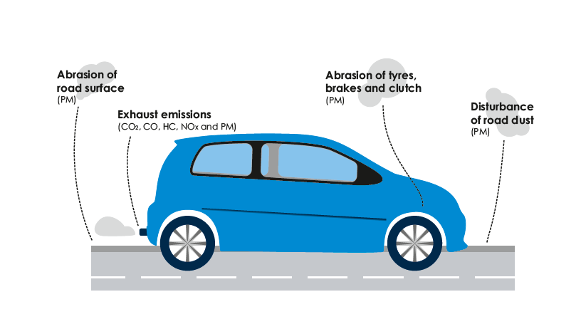


4.44 It is expected that, in the relatively near future, non-exhaust emissions will be dominant in road transport, and reducing single/low occupancy road travel will be required to achieve improvements in air quality.
4.45 Reading has one of the cleanest bus fleets in the UK, and we have secured over £1.5 million of funding from central government to upgrade the remaining buses to the latest green emissions standards. Reading Buses has also trialled an electric bus in Reading to understand how they could have potential to help improve Reading’s air quality.
4.46 The electrification of the Great Western Mainline and introduction of electric trains along the route has also reduced public transport emissions by reducing pollution from trains starting and stopping in, and travelling through Reading.
4.47 There is opportunity in Reading to improve air quality and correspondingly improve health outcomes for the area. Increasing sustainable travel mode share and reducing private vehicle (particularly single- occupancy) use is key to reducing transport emissions. Improvements to walking, cycling and public transport infrastructure, as well as increased promotion of sustainable travel options will support this mode shift.
4.48 Whilst the priority is to reduce overall levels of emissions and hence improve air quality, measures to reduce people’s exposure to poor air quality are another important aspect. Examples include segregating walking and cycling from busy roads; the introduction of green infrastructure; and encouraging behavioural change such as reducing engine idling or using different walking routes.
Reducing through-traffic and congestion
Despite significant investment in public transport and active travel improvements, traffic and congestion around Reading continues to grow. Demands on travel may change following the pandemic. It is likely that substantial investment and infrastructure will be needed to encourage people to make sustainable travel choices, and to provide alternative, more suitable, routing options for through-traffic.
Due to a relative lack of orbital routes, a large proportion of drivers travel via the Inner Distribution Road (IDR), further adding to town centre congestion. Many trips using the IDR could take a more direct or appropriate route, if orbital route improvements or other transport alternatives were in place.
Car congestion has significant negative impacts on our public transport network and services. Public transport is critical to travel and movement around Reading: 22.2 million journeys were made by bus in 2019/20 (56). Whilst Covid-19 led to a reduction in bus usage, passenger numbers are now recovering, and increased bus usage will be critical to reducing congestion.
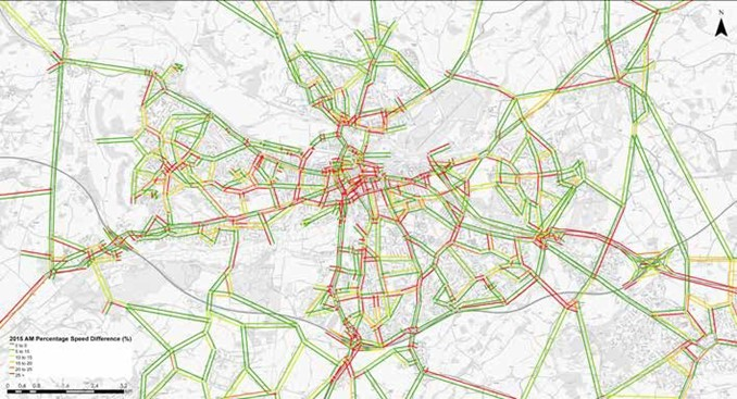
4.49 Reading significantly benefits from good access to a variety of strategic transport
networks, such as the Great Western Mainline and M4. This provides good connectivity
not only locally with nearby other major centres such as Slough and Basingstoke,
but also nationally, with associated economic opportunities. However, strategic
connections running from west to east are of a higher quality than those running from north to south, and therefore north-south connections can frequently be congested. Furthermore, whenever there is disruption on these key routes, this has significant congestion implications for Reading as a whole.
4.50 Furthermore, due to a lack of alternative local strategic north-south connections, there are high levels of through-traffic with no origin or destination within the borough. This adds to high levels of congestion in the town centre, on the bridges over the River Thames, and along key road corridors.
Additionally, more than half of car driving commuters living and working within the Reading area do not have an origin or destination within the Central Neighbourhood Area (57), and instead travel around the edge of Reading. Due to a relative lack of orbital routes, many of these drivers travel via the IDR, further adding to town centre congestion (58).
4.51 For employment trips within the Neighbourhood Areas, the proportion of people travelling by car is relatively low, at 51%. However, for trips starting or ending outside the Reading area, this rises to around 86% (59). This leads to increased levels of traffic and commuter car congestion within the Neighbourhood Areas as traffic travels into and out of the town.
4.52 Delays are generally worse at signalised junctions, particularly those that are not operating the latest technology, and in local centres where traffic mixes with people, as shown in Figure 21.
4.53 Despite significant investment in public transport and active travel improvements, traffic and congestion around Reading continues to grow. More substantial investment and infrastructure is needed to encourage people to make sustainable travel choices, and to provide alternative, more suitable, routing options for through- traffic.
4.54 Car congestion has significant negative impacts on our public transport network and services. Public transport is critical to travel and movement around Reading: 22.2 million journeys were made by bus in 2019/20 (60).
4.55 Whilst Covid-19 led to a reduction in bus usage, passenger numbers are now recovering, and increased bus usage will be critical to reducing congestion.
4.56 We have invested heavily in public transport priority across the town and many of the primary routes into and out of the town centre have bus priority, but there are some roads with a high bus service frequency that do not. These routes would benefit from the introduction of bus lanes and other measures to improve bus journey times and reliability.
4.57 Furthermore, there are a number of locations away from the key corridors where historically car congestion builds up, particularly in the peak hours and at school times, and causes delays to bus services, as illustrated in Figure 22. Whilst there is existing bus priority at some congestion hotspots, there are locations where bus priority is not present and, if introduced, would improve service frequency and reliability, making bus services more attractive in Reading.
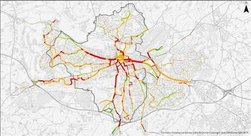
4.58 Delays are also caused where there are obstructions in the carriageway, such as on-street parking and delivery and servicing. The introduction of a Red Route no-stopping restriction along Oxford Road and Wokingham Road aims to keep public transport moving and reduce delays for passengers, whilst also improving safety for pedestrians and cyclists. The scheme includes parking and loading bays, to provide appropriate places for vehicles to park, whilst not obstructing vehicle movements.
4.59 There is an opportunity to introduce similar measures along other corridors in Reading, especially in local centres, where movements conflict and buses experience delays.
Providing affordable and accessible travel for all
We want Reading to be a town where everyone, regardless of background, disability, income, age or gender, can easily and safely travel around. Our transport system needs to be accessible to all, providing access to employment, education, healthcare and leisure opportunities, to allow our growing town to thrive.
The Covid-19 pandemic, and subsequent cost of living crisis has resulted in a period of deep economic uncertainty and anxiety for many residents and businesses. Our transport strategy and policies will need ensure it supports the economic recovery of all sections of society.
4.60 The RTS is supported by an Integrated Impact Assessment, prepared in accordance with statutory requirements including the Equality Act 2010. Likely different impacts of different demographic groups and people with protected characteristics have therefore been considered throughout the preparation of the RTS.
4.61 Specific demographics groups have been identified as most likely to be vulnerable to transport impacts. These are people on low incomes, people with health issues of disabilities, and older people. We have also considered Reading’s diversity, and how other groups may be affected by transport.
Income Deprivation
4.62 Incomes in the Reading urban area are generally high, but there are areas of deprivation, particularly in the Whitley, West Reading and Lower Caversham, as shown in Figure 23 (61).
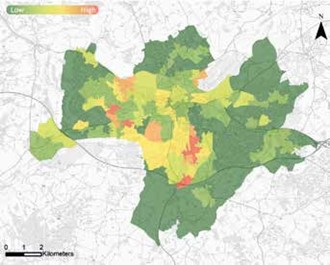
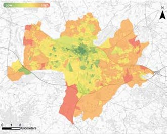
4.63 These areas generally correspond to areas of lower car ownership Figure 24 (62)), and so these communities are more reliant on public transport, as well as active travel. It is therefore important that bus services in these areas are frequent, affordable and of high quality, and that walking and cycling networks are comprehensive, facilitating liveable neighbourhoods. This will enable convenient and direct access to employment opportunities and other facilities.
4.64 Outer parts of the Reading urban area, particularly outside the borough boundary, generally have high incomes and correspondingly high car ownership. These areas also typically have less frequent and slower bus services, as there is very limited bus priority outside Reading borough. Consequently, a high proportion of trips from these areas to/from Reading are made by car, increasing car congestion on local Reading roads. Priority for public transport services is needed, including Park and Ride services, to increase their attractiveness.
4.65 We are in the middle of a cost-of-living crisis, which is affecting large proportions of the population, including those typically classed as middle-income. It is critical that people’s ability to access sustainable transport is maintained and improved to support people to be able to travel to work, either where they have no other means available, or to prevent a switch to private car due to perceived high public transport costs.
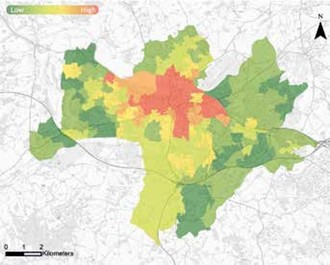
Health and Disability
4.66 Parts of the Reading urban area, particularly in the town centre, Whitley Coley and West Reading, have relatively high levels of health and disability deprivation. There are high levels of car congestion on roads around the town centre and along key road corridors in Reading. This leads to low environmental quality and high levels of air pollution, negatively affecting people’s mental and physical health. This is reflected in Figure 25 (63). Overall, 12.9% of people in Reading report having a limiting long-term illness or disability (64).
4.67 Sustainable transport provides a significant opportunity to improve quality of life for those with health issues or disabilities through providing access to local services and reducing social isolation. A high-quality, accessible transport network is important to provide disabled people with equal opportunities. In Reading, much has been done to improve the transport experience and accessibility for disabled travellers. Readibus provides door-to-door assisted bus services which are free to use for disabled people with support from Reading Borough Council.
4.68 All buses operated by Reading Buses are wheelchair accessible and most now have audio and visual on board stop announcements.
4.69 However, there are still many barriers facing disabled people to use public transport. Common barriers include:
- Narrow, uneven or poorly maintained pavements
- Dropped kerbs that are not flush with the road surface
- Very high or very low kerb heights
- Poor colour contrast
- Pavement obstruction by parked vehicles, street furniture and overgrown vegetation
- Use of disabled parking spaces by non-disabled drivers
- Difficulties navigating shared spaces
- Limited availability of travel information in accessible formats
- Cost of travel for those on lower incomes
- Lack of alternative provision where there are steps
- Availability of assistance and support
- Location and availability of disabled parking spaces
- Not having the right types of disabled parking spaces for access and egress from the different types of vehicles
- Need to utilise adapted vehicles
- Lack of well placed dropped kerbs associated with disabled parking
Older People
4.70 There are high proportions of older people clustered in parts of the Reading urban area, particularly in the outer parts of the borough and neighbouring authorities, as shown in Figure 26 (65).

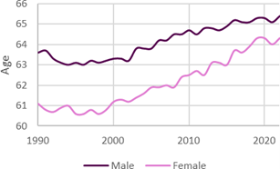
4.71 33% of people aged 65 and over living in Reading live alone (66, 67) and are therefore more likely to be socially isolated and experience loneliness. Older people are also less likely to own and drive a car (68, 69) and may be less mobile. Those that do own and drive a car may be dependent on their vehicle for travel due to limited mobility and other health conditions, which may prevent active travel or use of public transport. Those that do not own a car are often reliant on public transport to meet their transport needs.
4.72 Access to transport for older people is critical to facilitate social interaction within their local communities, improving their mental and physical health.
4.73 Some of the areas of Reading with high populations of older people are less financially viable environments in which to operate traditional commercial bus services. This is due to a high proportion of residents and bus users that may have concessionary travel passes which are used for a free off- peak bus travel.
4.74 Some older people will still be travelling in the morning peak period when free travel is not available, whether for work or other reasons. Average retirement ages in the UK have been increasing, as shown in Figure 27, with an increase of 1.8 years for men, and 3.2 years for women between 1990 and 2022 (70). This is likely to lead to an increased demand for travel for older people in Reading, as a larger proportion of the population continues to travel for work for longer. By 2040 the number of people living in Reading aged 65 and over is expected to increase by 41% (71).
4.75 However, a high proportion of older people will likely be travelling outside peak travel times for leisure, shopping and health or personal appointments rather than for work or education. Nevertheless, bus services provide important connections for residents to local facilities, and so it is important that a good bus service can be provided.
4.76 Older people may also be less familiar with technology than younger generations, and so it is important that travel information and tickets are available in accessible formats, such as print or telephone.
Diverse Communities
4.77 We need to ensure our transport network is designed to enable all of our residents, regardless of background, race, culture, religion and beliefs, sexuality, age or gender, are able to travel safely and easily.
4.78 The needs and safety of more vulnerable residents in Reading is a key consideration for future travel options.
4.79 Reading is highly multi-cultural, and has the 11th highest proportion of residents born outside the UK of any non-London local authority in England (72).
4.80 The median age of Reading residents is 35 – the 20th youngest of any UK local authority outside London (73). Opportunities for teenagers and young adults, including generation Z, to access sustainable transport is a key consideration for the delivery of this strategy.
4.81 Access to public transport for those without access to a car is critical to preventing social isolation, particularly for young families, as well as the older, disabled and less-able people.
4.82 Younger travellers, in particular children, may have more difficultly than the average user in understanding complex information and responding to changes on the network (for example delays or cancelled services). Provision of appropriate information is therefore key to enabling younger people to use the network.
4.83 In addition, children are more vulnerable whilst travelling, and so our transport network needs to be safe and secure, so that children feel comfortable whilst travelling and are able to travel independently. Our transport network needs to be safe and secure, so that vulnerable groups, including children, feel comfortable whilst travelling and are able to travel independently.
4.84 Some of our residents have lower levels of English proficiency. Travel around Reading can be inherently more challenging for these people, as the majority of travel and route information is in English. This could discourage the use of public transport by people with lower levels of English proficiency, which could lead to reduced opportunities and increased social isolation.
4.85 We recognise that certain sections of the community are much more likely to work in careers which are dependant on car use. In promoting modal shift, we will give due consideration to these needs.
4.86 There are a large number of visitors to Reading every year. Some of these are visitors on business, and others are for leisure reasons, such as Reading Festival. Visitors are less likely to be familiar with Reading and the transport network, and therefore clear and visible information is needed to allow them to plan and carry out their journeys.
4.87 Safety and security on our transport network and the provision of accessible information for all are key challenges we have identified in supporting our diverse communities in Reading.
Removing barriers to healthy lifestyles
Reading’s pedestrian network and public space has had significant investment over the years, but there are areas of the town which require enhancement, such as the street paving, landscaping and furniture. Improvements are also needed to better accommodate pedestrian movement and desire lines.
The quality of the environment in parts of the town is good, especially areas where enhancements have been delivered in recent years. However there are local centres and parts of the town centre where improvements to the public spaces and streets will create a more welcoming and attractive space, with better provision for all people walking, cycling and those who are mobility impaired.
During the Covid-19 crisis the government measures in the lockdown allowed for one form of outdoors exercise per day. As a result, many people re-discovered the footpaths, roads and parks in their local neighbourhoods, as well as recognised the benefits of being outside for their physical and mental well-being. In a post-Covid world, creating and maintaining attractive spaces and removing barriers to healthy lifestyles will help this behavioural change to be permanent.
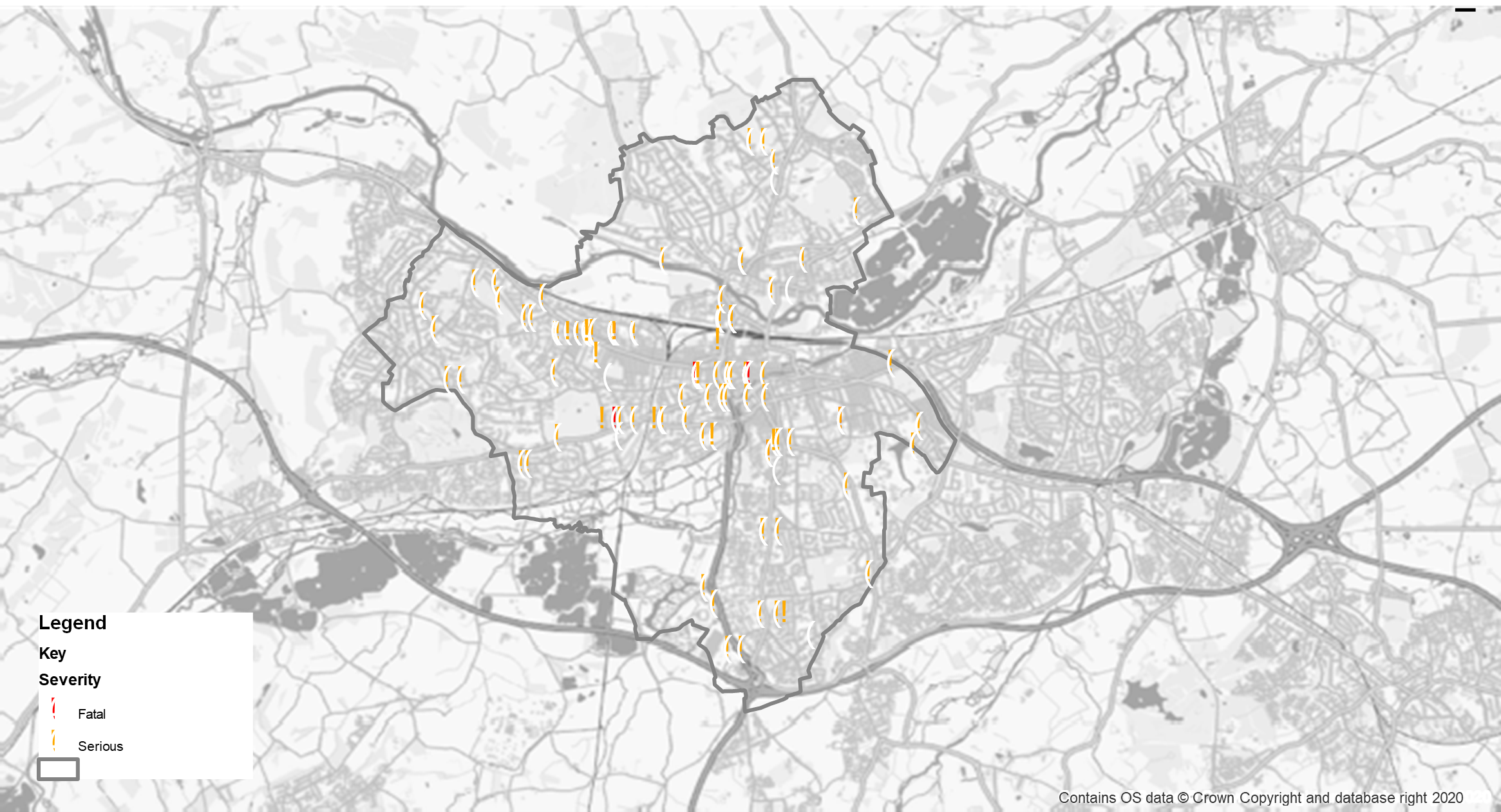
4.88 Safety is an important consideration for this Strategy. We have reviewed vulnerable road user collisions in the last five years, shown in Figure 28, to understand existing road safety issues and inform the development of the RTS. Areas where pedestrian movements conflict with vehicle movements can be perceived as feeling less safe than areas which have been designed with greater pedestrian-only space.
4.89 Pedestrians crossing the road can sometimes be subject to undue delay, where the street design currently prioritises cars. Whilst 29 traffic signal junctions were upgraded in the town as part of the LSTF programme, many still operate outdated technology. Upgrades to modern traffic signal systems and improved crossing facilities would better enable priority to be given to pedestrians, creating a more pedestrian-friendly environment and further encouraging walking.
4.90 We recognise that wider societal and cultural issues, including anti-social behaviour, can significantly impact both personal safety and perceptions of safety which can act as barrier to sustainable travel usage. This can have a particular impact on people choosing to walk and cycle in the winter months, which in turn can have a knock-on impact on usage of bus and rail services.
4.91 An example of this is work undertaken in London which demonstrates that a high proportion of women in the capital have suffered from harassment, including in public spaces and on transport services. Work has been undertaken by Transport for London (TfL) with the objective of improving women’s safety on their network, including ‘Project Guardian’ and the ‘Report it to Stop it’ communications campaigns – both of which aimed to improve reporting levels and to create an environment on the network that does not tolerate intimidation and harassment. This work has been undertaken in partnership with the British Transport Police, Metropolitan Police Service and City of London Police.
4.92 This demonstrates that initiatives can be undertaken to help address these issues, and it is important to ensure that public spaces and transport systems are designed with all users in mind. This can then be supported by additional initiatives which take into account different user needs with the objective to make public places and transport services more inclusive and equitable.
4.93 These wider societal and cultural issues are critical considerations, both for the development of this strategy and in delivery of the individual schemes and initiatives within it. However, it is recognised that it is not possible for every car journey to be replaced by a more sustainable mode and therefore the strategy also includes the objective of a transition to electric vehicles which have a significantly reduced impact on carbon emissions than diesel and petrol equivalents.
4.94 Opportunities exist to deliver improvements to the public realm, enhancing the townscape and delivering environmental benefits through planting, and also encouraging healthy lifestyles and outdoor social activity.
4.95 Wayfinding in Reading has been improved through localised schemes which have delivered new and upgraded signage, however, consistent signage across the town centre and wider borough is not yet in place. This makes sustainable travel less attractive, particularly for people unfamiliar with Reading. Therefore, there are opportunities to improve signage to encourage walking, cycling and bus use as a preferred mode over private car, both for a complete trip, and as part of a multi-stage trip.
4.96 Over the years, Reading has developed and signed a series of branded and coloured coded local cycle routes, shown in Figure 29, which provide connections between suburban areas and the town centre linking to key facilities and services, including schools, employment, leisure facilities and local centres.
4.97 Our local cycle network is complemented by four National Cycle Network routes (4, 5, 23 and 422), linking Reading to major towns and cities. The network is made up of a combination of on and off-carriageway facilities, and designated quiet streets, and covers the wider Reading area.
4.98 The local cycle network is supported by a number of unbranded routes along quiet streets, providing feeder routes to the main network. An interactive map for walking and cycling is available on our website.
4.99 In some areas, additional local routes are required, to better connect communities to local facilities, employment areas and the town centre. This will increase the attractiveness of cycling in Reading.
4.100 Reading also suffers from bicycle theft, particularly in the town centre and other areas. Whilst additional secure bicycle parking has been delivered in recent years, such as at the northern interchange of Reading Station, there is further opportunity for more secure and smarter bicycle parking across the town such as concierge services.
4.101 Additionally, there are improvements that could be made to existing bicycle parking to provide increased levels of security, protection against weather and better storage for larger bicycles.

Achieving good accessibility to local facilities and employment
Local facilities
4.102 Within the wider Reading area, access to local facilities varies significantly, depending both on the type of facility and the location. Overall, access to public transport stops is good, with 90% of Reading residents living within 400 metres of a bus stop. However, accessibility to other amenities is significantly lower, with the majority of people living outside typical reasonable walking distances, as shown in Figure 30.
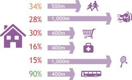
4.103 Our Local Plan sets out requirements for appropriate provision of new facilities in Reading, such as schools, but the location of these facilities is broadly determined by developers, rather than the Council.
4.104 Accessibility to schools is reasonable in many areas, however, residents within the Central Neighbourhood Area, and parts of the Northern and Western Neighbourhood Areas are located a significant distance from both primary and secondary schools. The Western and Northern Neighbourhood Areas also have areas a significant distance from a local retail centre, along with the South Western Area.
4.105 GPs are often located close together, meaning they serve a wider catchment area, and can be a significant distance from some patients.
4.106 Many sports facilities are located where there is green space, for example at major parks, and so the opportunity to relocate or expand provision can be limited.
4.107 Many local facilities in Reading are clustered in groups. This can lead to benefits, as people are able to access multiple facilities in one trip, and these hubs often serve as the heart of local communities. However, these clusters of facilities can also lead to a greater proportion of residents living further away from them or can encourage increased car usage.
4.108 Access to the Royal Berkshire Hospital is particularly challenging leading to car congestion and a perceived difficulty in finding somewhere to park. Greenwave bus services between Mereoak Park and Ride and the hospital provide a useful and easy to use alternative for many hospital visitors Numerous buses link the hospital with Central Reading but relatively few offer direct links from residential areas of Reading.
4.109 Nationally, just over 40% of trips by all modes of transport in the morning peak hour are associated with education (74).
4.110 There is a high level of car use for trips to and from school in Reading, contributing to congestion in the peak hours, and an extended afternoon peak period. The level of physical activity for children is reduced and in Reading 39% of children are overweight or obese by the time they leave primary school (75). There is an opportunity for local facilities to be served by high-quality, frequent bus services, in order to reduce car travel where possible, and to enhance access to amenities for people who do not own a car.
4.111 Additionally, accessibility to local facilities should influence future land-use planning, to enable delivery of key amenities where they are required most, reducing the need to travel for communities. There is an opportunity with new developments to deliver facilities that serve both new residents or employees, and existing communities in the local area, contributing towards a shift to sustainable travel and also increasing social cohesion.
Employment
4.112 Up to 45% of car trips on the network in peak hours are related to employment (76). Whilst many areas of employment in and around Reading, such as the town centre, have good accessibility by sustainable modes, others are more accessible by private car, particularly for those not travelling from origins along the same radial corridor.
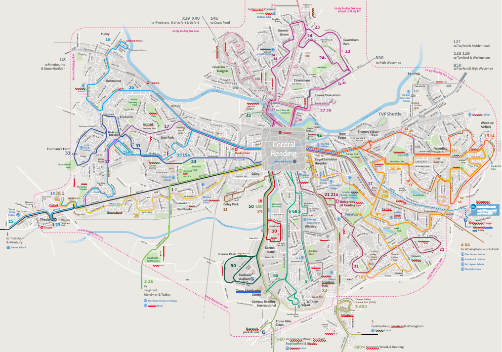
4.113 This leads to high levels of congestion on our network in peak hours, reduced levels of active travel and increased journey times, which leads to losses in productivity.
93% of local businesses that responded to a recent survey believe congestion affects productivity (77).
Accommodating development
Significant development is planned in Reading and the surrounding area with around 16,000 homes planned to be delivered between 2013 and 2036 in Reading alone (78). Within Reading and the nearby local authority areas of South Oxfordshire, West Berkshire, Wokingham, Bracknell, Basingstoke and Deane, and Hart, over 5,000 homes are planned to be delivered each year and many of the people living in these homes will travel to Reading.
The Covid-19 pandemic resulted in a significant and immediate downturn in the economy, and the lasting lasting impact will be on the national and local economy is now emerging.
The need for new homes has continued to grow despite the impact of the pandemic. Therefore we will need to provide improvements to accommodate these additional travel needs and enable development to be delivered without affecting the health and wellbeing of residents within the borough.
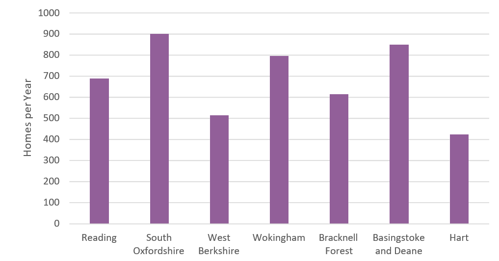
4.114 Reading is also an employment hub, and significant growth in employment floorspace and jobs is anticipated within the town and greater Reading area. The region’s economy is forecast to be the UK’s second fastest growing economy in the South East between 2022 and 2025 (79).
4.115 The spatial strategy for development in Reading and the surrounding area is set out in the Local Plans for each Local Authority.
4.116 Without interventions, car traffic is predicted to increase as a result of development, leading to additional demand on roads across Reading, particularly key corridors. Levels of rat-running traffic through residential areas are forecast to increase, as car drivers seek to avoid congestion. The RTS is therefore key to implementation of Reading’s Local Plan, and will also support neighbouring Local Plans.
4.117 Development and transport need to be planned together, to enable people to make sustainable and healthy travel choices, to make best use of existing resources, and to encourage integration of communities. Transport improvements will be required to support development of proposed sites and overall increases in travel in and around Reading.
Our policies
Introduction
5.1 This chapter sets out our policies to support delivery of the overarching transport vision and objectives for Reading. These supporting policies are broken down by individual theme and provide the guiding principles for implementation of the strategy. This chapter also highlights the key statutory duties the Council must fulfil in its role as a Local Highway Authority.
5.2 The policies are summarised in the following sections:
- Multi-modal
- Public transport
- Active travel
- Network management
- Communication and engagement
5.3 The Reading Transport Strategy (RTS) is supported by a number of sub-strategy policy documents, which provide additional detail on various themes. A current list of these sub-strategies is included at the end of this chapter. Further supporting strategies may be developed over the life of the RTS.
Multi-Modal Policies
Sustainable Transport
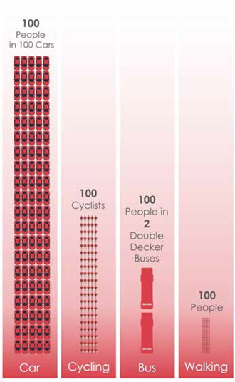
5.4 We want to achieve a step change in the provision of walking, cycling and public transport choices for people travelling to, from and within Reading.
5.5 This will help us to achieve our overall vision for transport in Reading including enabling healthy lifestyles and creating a clean and green environment. It will also support our aim of providing an accessible transport system for all, and enable sustainable developments to come forward and to provide opportunities for local residents.
Policy RTS1 – Sustainable Transport
1.1: We will prioritise sustainable travel modes to offer an attractive and realistic alternative to private car trips.
1.2: We will increase the capacity of the sustainable transport network by reallocating road space to sustainable modes.
1.3: Where we reallocate road space away from private cars, we will deliver complementary measures, such as Healthy Streets, on local residential roads to reduce any potential through-traffic and rat-running.
1.4: We will promote the use of electric vehicles or alternative ultra-low emission vehicles for essential car journeys.
1.5: We will complement any increase in general traffic capacity with sustainable transport improvements.
1.6: We will work with neighbouring authorities and other significant land owners to identify land suitable for delivering transport infrastructure.
1.7: We will support schools, businesses and organisations to develop travel plans, and to join national travel accreditation programmes, such as Modeshift STARS.
1.8: We will deliver mobility hubs, integrating multiple modes of transport in a single location to allow easy interchange and mode choice, encourage sustainable travel and reduce transition times between modes.
The environment and climate change
5.6 The environment plays a key role in supporting the quality of life, health and wellbeing of our residents. The RTS will support the environment, including the aspirations of our Climate Change Strategy which sets out our ambition to become a carbon neutral town by 2030.
5.7 Opportunities will be delivered through the RTS to enhance the local environment through the creation of healthy streets and the greening and provision of better transport links to encourage increased use of our rivers and parks.
![The image shows a triangular diagram illustrating sustainable design principles, arranged from "Lesser Impact" at the bottom to "Greater Impact" at the top. The hierarchy consists of five levels:
At the bottom: "Specify Low Carbon" - Use low carbon materials and construction methods
Second level: "Increase Efficiency" - Reduce materials and minimize waste
Middle level: "Build Clever" - Adopt existing infrastructure
Fourth level: "Challenge the Brief" - Identify a non-construction solution
At the top (greatest impact): [No specific text label for the apex]
A vertical arrow on the left side indicates the progression from "Lesser Impact" to "Greater Impact" as one moves up the triangle. The diagram uses a green color gradient that darkens toward the top, emphasizing how higher-level interventions have greater sustainability impacts than lower-level ones. The graphic appears to be a framework for prioritizing sustainability approaches in construction or design projects.](https://images.reading.gov.uk/2023/09/Embodied-carbon-reduction-hierarchy.png)
Policy RTS2 – The environment and climate change
2.1: We will design our schemes to improve the built and natural environment, enhancing the quality of life of our residents.
2.2: We will ensure transport schemes deliver improved air quality, reduced emissions and biodiversity net gains.
2.3: We will adapt our transport network to prepare for climate change.
2.4: We will protect and promote the heritage of our town, whilst improving access to places of heritage interest.
2.5: We embed consideration of whole life carbon in transport projects from the outset, through planning, option selection, design, procurement, construction and management stages, and will seek to reduce whole life carbon where feasible.
2.6: We will seek to reduce embodied carbon in transport infrastructure projects, where feasible, in line with the embodied carbon reduction hierarchy shown in Figure 34.
Equality and inclusivity
5.8 The Equality Act sets out our statutory duty to ensure that our policies and services do not discriminate against anyone and that we promote equality of opportunity, including the provision of transport that is accessible to all. All proposals that are considered at Council committee meetings are currently reviewed in line with Equalities Impact Assessment requirements.
5.9 The Inclusive Transport Strategy (ITS), published by central government in July 2018, builds on the Equality Act and sets out ambitions for inclusive transport whereby disabled people have the same access to transport as everyone else and for them to travel confidently, easily and without extra cost.
5.10 Considerable investment has already been made in ensuring the Reading Buses fleet is accessible to all through the provision of low-floor buses, complemented by audio messaging, on-board bus screens and accessible kerbs.
5.11 Improving inclusion means giving people safer, healthier and more affordable transport options. In turn this helps ensure people can remain independent and active lifestyles for longer and access key local facilities and services, such as leisure and health.
5.12 Affordability of transport is key to providing equality or opportunity and connectivity across Reading, particularly to those on lower incomes. We will continue to deliver schemes and programmes that reduce the cost of travel, provide alternative and more cost-effective modes of travel or help give people the information or skills they may need to travel more cheaply. Our concessionary fares and cycle training programme, Bikeability, are two examples of ongoing initiatives offering people on low incomes cost-effective travel choices.
Policy RTS3 – Equality and Inclusivity
3.1: We will work with transport operators to deliver an accessible network for all, taking action to address barriers caused by physical infrastructure.
3.2: We will continue to undertake Equalities Impact Assessments as part of the development of new schemes and policies, as a minimum in line with our statutory requirements, to enable us to deliver transport improvements that cater for all residents.
3.3: We will continue to work with partners to deliver public transport, such as bus, community transport and taxi operators, that is affordable and accessible to all and reduce inequalities in our communities.
Demand Management
5.13 Demand management measures such as reallocating road space to sustainable modes, width and weight restrictions and road user charging can be used to reduce peak car demand and congestion in Reading, encourage appropriate vehicle routing and support travel by sustainable modes.
5.14 These measures can help to improve the lives of our residents by improving air quality, reducing congestion and accidents, and enabling healthy lifestyles.
Policy RTS4 – Demand Management
4.1: We will develop demand management measures to reduce congestion and improve the quality of life of our residents and prepare a supporting business case to implement potential schemes.
4.2: Demand management measures to reduce traffic will be complemented by measures to increase capacity for travel by sustainable modes and measures to reduce rat-running traffic through residential areas.
4.3: We will reinvest revenue generated by demand management measures in Reading.
4.4: Any demand management measures will be developed with equalities as a key focus, and with consideration of those who are reliant on private vehicle travel.
Development Control
5.15 Our Transport Development Control team is a statutory consultee of the planning process and provides technical advice on the transport and highway implications of each development proposal submitted to the Planning Authority. They work collaboratively with developers to influence the transport approach and details of development, so that highway safety, convenience and amenity are improved through development, to avoid environmental degradation and to support economic activity, whilst enabling the delivery of our Local Plan.
5.16 We have developed a transport model for Reading, which we will require major proposals to use to test the impact of development on the town. Our access charge allows us to update and upgrade the model, so that it provides a suitable baseline for testing the implications of development growth in Reading and the wider area.
Policy RTS5 – Development Control
5.1: We will work with developers to design development that supports delivery of the Reading Transport Strategy and helps achieve our vision for transport in Reading.
5.2: We will work with developers to secure land for transport infrastructure where required.
5.3: New developments will be required to demonstrate how they will deliver healthy streets, and provide connection to new and existing facilities, making a positive contribution to the walking, cycling and public transport network and supporting sustainable and low-carbon travel.
5.4: We will require developers to develop and submit travel plans aligned with the vision and objectives of the RTS, including climate, equalities and health and wellbeing priorities. We will also require developments to carry out and submit evidence of travel plan monitoring, and will require remedial actions to be taken as appropriate, in line with relevant planning consents.
5.5: Private sector contributions, including Section 106 and the Community Infrastructure Levy, will be used where appropriate to improve the transport network and mitigate the impact of development, including through enhancement of walking, cycling and public transport facilities.
5.6: We will work with developers to maintain access during construction works for sustainable modes of travel as far as possible.
Sustainable modes of travel to school
5.17 It is vital that public transport and active travel options are available for all children to access education to improve children’s physical activity levels through increased walking and cycling. Our overarching aim for school travel is therefore to increase the number of children walking, cycling or taking public transport and in reducing the number of car journeys to schools.
5.18 The Council has a statutory duty to develop and keep under review a Sustainable Modes of Travel Strategy (SMoTS) to school, which is a statutory document under the Education and Inspections Act 2006.
5.19 Our SMoTS includes policies to assist all schools with developing, implementing and monitoring ambitious school travel plans and increasing the use of sustainable transport options for travel to school. It also identifies the responsibility for providing road safety education and national standard cycle training and defines the process for developing measures to create safe routes to schools.
Policy RTS6 – Sustainable Modes of Travel to School
6.1: We will keep our SMoTS strategy updated to reflect our priorities in delivering the national sustainable schools accreditation programme, Modeshift STARS, and new initiatives, such as school streets, seeking to create safer and more attractive environments around schools.
6.2: All schools will be incentivised to renew their school travel plan annually as part of the national accreditation scheme – Modeshift STARS and set ambitious targets to increase the percentage of the school community walking, cycling and using public transport.
6.3: We will encourage and support the promotion of sustainable travel to schools through implementation of education, training and initiatives, such as Modeshift STARS, Bikeability and school streets.
6.4: We will work with school communities to identify barriers currently preventing sustainable travel, and provide solutions to create safer and more attractive sustainable travel routes to schools. We will provide additional support to schools in deprived areas and to SEND schools, as required.
Smart Solutions and Innovation
5.20 It is anticipated that technology will continue to transform the way we work and travel within our plan period. We will strive to remain at the forefront of technological advancements where they provide real benefits to those who live and work in Reading and where they reduce carbon.
5.21 Reading is home to many high-tech companies and start-ups providing opportunity to collaborate and deliver innovation with the private sector.
Policy RTS7 – Smart Solutions and Innovation
7.1: We will embrace the latest technologies to improve the efficiency and resilience of the transport network for the benefit of those who live, work and study in Reading.
7.2: : We will work with businesses to encourage the use of technology to reduce the need to travel and encourage hybrid working as appropriate considering the type of work and the relative carbon footprints of homeworking and travel to work. As a Council we will lead by example.
7.3: : We will continue to promote Reading as a town that actively encourages and supports the testing of innovative solutions to defined transport challenges.
7.4: We will utilise ‘big data’ and data analytics, where available, to facilitate informed decision-making to allow us to take actions resulting in real reductions in carbon, other environmental benefits and health and wellbeing benefits for local communities.
Public transport policies
Public transport
5.22 For sustainable and successful growth, public transport will need to play a major role in delivering the vision of the Strategy across the plan period to 2040. A well- integrated, attractive and efficient public transport network is essential for meeting people movement demands of the future. Public transport can provide an alternative means of travel to the private car. If public transport provides attractive journey times, reliability and/or reduced cost compared to the private car, it can result in reduced congestion and emissions.
Policy RTS8 – Public Transport
8.1: We will continue to build on the well- established bus and rail connections and work with partners across Reading and the wider region to maintain and improve an accessible, affordable reliable and sustainable, integrated public transport network.
8.2: We will support the evolution of public transport as technologies advance and new types of services become viable.
8.3: We will work with operators to seek to reduce public transport fares, to encourage mode shift away from the private car.
Bus and Community Transport
5.23 Bus services provide the everyday access for millions of journeys each year within, to and from Reading. Buses represent the most efficient use of road space for the transport of people going to the same corridor or location. Despite this, buses are often seen stuck in queues of low occupancy cars going to the same place.
5.24 We will continue to invest in bus priority to improve the operation of buses to provide more capacity, more frequency, high quality and faster journeys, working with bus operators to re-invest the efficiency savings in improved services.
5.25 We recognise the contribution of Reading Buses as main public transport operator and major employer in Reading for over 100 years. The company is wholly owned by Reading Borough Council and a major asset in the provision of sustainable transport and the future development of inclusive and sustainable travel in Reading.
5.26 Cross-town access from residential areas to schools, workplaces and the hospital is sometimes difficult and bus services will need to be developed to meet these travel needs.
5.27 We will continue to support the development of high-quality Bus Rapid Transit (BRT) and Superbus Network services serving new development areas including business parks and housing in and outside of Reading. This will involve continuing to work with neighbouring authorities to secure investment in the transport network through new development. This will include investment in BRT routes connecting strategic Park and Ride sites and offering easy interchange with fast journeys into central Reading and key locations, for example the Royal Berkshire Hospital.
5.28 We will continue to work with education providers to ensure that school bus services are developed to support other sustainable ways of access to school and reduce the negative effects of cars on ‘the school run’.
5.29 Community transport, including dial-a-ride services plays a key role in enabling those who are unable to use public transport to live independent lives. The main dial a ride provider in Reading is Readibus who offer a comprehensive service, with support from local authorities, to support people who live in our local communities. We currently provide subsidy towards this service.
5.30 We will work with adult social care and health services with regard to the role of transport in tackling loneliness and improving health, particularly in the elderly, and support community support initiatives such as social subscribing where they come forward.
5.31 Our Bus Service Improvement Plan (BSIP), developed in partnership with local operators and neighbouring local authorities, is a supporting sub-strategy to the RTS. It outlines our ambitious plans to transform bus services in Reading, initially to build back passenger levels which reduced during the Covid-19 pandemic, and subsequently to encourage more patronage on buses. Our BSIP provides a collection of detailed policy statements and actions to be implemented.
Policy RTS9 – Bus and Community Transport
9.1: We will work with bus operators, businesses, health and education providers towards delivering high quality fast, frequent and reliable bus services that are not forced to take second place to excessive or inappropriate car use.
9.2: We will dedicate space on the highway to buses or shared with buses, taxis, cycles and emergency vehicles, to ensure equality of urban mobility, and to free up space for regeneration of streets with planting and improvements to the public space.
9.3: We will work with neighbouring authorities and other parties to enable the provision of community transport services in Reading for the benefit of our residents and reduce social isolation.
9.4: We will work with health services and adult social care services and communities to deliver accessible public transport services that work for communities and help address social needs, such as keeping elderly mobile and tackling loneliness.
9.5: We will work with neighbouring authorities to deliver Park and Ride Mobility Hubs and associated Park and Ride bus services to enable mode shift away from the private car for travel to Reading.
9.6: We will work with bus operators to support and encourage a shift towards the use of zero emissions vehicles.
Rail
5.32 Reading’s central location at the meeting point of seven rail lines and the historic development of frequent train services has given Reading a unique train network and we recognise the importance of Reading as a national rail hub and the contribution of train services to mobility to and from Reading. This has been enhanced by the redevelopment of Reading Station, the opening of the Elizabeth Line, the delivery of Green Park station and the upgrading of many of the trains used on Great Western Railway services.
5.33 Recognising that train is by far the quickest way into or out of Reading in virtually any direction, the local and longer links need to be developed by train companies and supported by Reading Borough Council as alternatives to increasing car use in the Thames Valley. We are a statutory consultee on train operating company franchises and Network Rail plans and will continue to work closely with these companies to ensure Reading is served by the maximum level of train services and at a consistent quality that passengers would expect. We will continue to challenge fares anomalies and poor services and at the same time support the development of improved train services where there are needs.
5.34 Western Rail Link to Heathrow remains a Network Rail project for delivery which will open-up direct access by train from Reading. The Council will continue to push for this service to be realised to help reduce the numbers of cars heading to Heathrow from the Reading area.
5.35 We will support improvements on the North Downs rail line between Reading and Gatwick through schemes such as bi-mode trains and electrification of the line to give faster more frequent journeys to the airport.
5.36 We will continue to support and encourage the development of ‘Park and Rail’ and initiatives to improve station access in the wider area.
Policy RTS10 Rail
10.1: We will continue to lobby for improvement and work with the rail industry including train operating companies to provide improved services for train travellers to and from Reading.
10.2: We will lobby for increased service frequencies between Reading Station and local rail stations, including Pangbourne, Tilehurst, Reading West, Theale, Reading Green Park, Earley, Winnersh and Winnersh Triangle.
10.3: We will continue to support the development of the other Reading Stations (Reading West, Tilehurst and Green Park) to ensure each is accessible and provides a high-quality entry to the rail network with high quality frequent and reliable train services.
10.4: We will lobby for decarbonisation of the rail network to be accelerated, including rail freight.
Taxis and Private Hire Vehicles
5.37 Taxi and private hire vehicles are a key part of the public transport network providing a service when other modes of public transport may be unavailable, or in areas that the current public transport network may not serve, allowing journeys that may not otherwise be possible to be made by public transport. This reduces the need for people to own private cars.
5.38 Our role seeks to ensure that providers of taxi and private hire services adhere to the quality obligations set out in the relevant licences, and are compliant with all relevant guidance on the conditions that arise from the application of the appropriate sections of legislation.
5.39 Alongside the Police, we can revoke taxi and private hire licences if the licence holder does not meet their obligations. A penalty points system is in place for breaches of regulations, as set out in the licence holder handbook. Through these mechanisms, we will continue to work with taxi and private hire providers to deliver high-quality and reliable taxi services in Reading.
5.40 Technology can play a huge part in making taxis more accessible to people with the introduction of apps, cashless pay systems and enabling ride sharing.
5.41 We are also responsible for providing and maintaining suitable taxi ranks and pick- up points, and we will continue to liaise with operators to maintain adequate and appropriately located facilities across Reading. We will continue to support a shift towards electric taxis and will work with taxi and private hire service operators to identify ways in which we can support fleet changes.
5.42 A new policy has been adopted to encourage taxi drivers to switch to cleaner vehicles to improve air quality and contribute towards the aim to be a carbon neutral town by 2030. We are initially offering incentives in the form of reducing licence fees for the cleanest vehicles. Since April 2020, a 25% reduction in the vehicle licensing fee for all Ultra Low Emission Vehicles (ULEVs) (emitting a maximum of 50g/km of CO2) has been available. A discount of 50% is offered for electric vehicles.
5.43 Additionally, by 2028, all hackney carriages in Reading will be required to be either electric or ULEVs. This is further supported by our EV strategy, which aims to reduce emissions from our taxi fleet, and private hire vehicles.
5.44 This will contribute towards reducing, and eventually removing altogether, the most polluting taxis on Reading’s roads, having a positive step towards combating the impacts of climate change.
Policy RTS11 – Taxis and Private Hire
11.1: We will work with operators to deliver smart, accessible and efficient taxi services across the borough.
11.2: We will work with taxi and private hire services, offering support and incentives to encourage a shift towards the use of cleaner vehicles.
11.3: We will work with taxi operators in Reading to transition to electric or hybrid vehicles by 2030.
Waterways
5.45 A number of leisure riverboat services currently operate along Reading’s waterways. River transport services do not have the same capacity for people movement as other public transport services, however we support the continued and increased use of our waterways by private operators to provide services for leisure and commuter services that could contribute to reducing congestion, where this would not cause unacceptable local problems.
Policy RTS12 – Waterways
12.1: We will work with private operators to seek opportunities for external funding for waterway schemes and improvements to the connecting networks.
12.2: We will encourage better walking and cycling access to waterways for leisure, tourism and recreation, as well as health and fitness, promoting waterways as key destinations, whilst recognising the need for consideration of impacts on the environment and existing communities adjacent to the waterways.
12.3: We will work with private operators and the Environment Agency to ensure safe and effective management of activities adjacent to and on the waterways, including boat usage.
Connected and Autonomous Vehicles (CAVS)
5.46 The government is committed to the UK being world leaders in the development and delivery of connected and autonomous vehicles (CAVs) and legislation that will enable CAVs to operate on the public highway without a ‘driver’ overseeing it.
5.47 Whilst there is significant uncertainty over when a private autonomous car that can go anywhere may come to the market, and whether we will see any within this plan period, there is a significant likelihood that Shared Autonomous Vehicles (SAVs) will come forward within the next 5 to 10 years.
5.48 These Shared Autonomous Vehicles, such as 15-seater pods operating with traffic in a demand-responsive way on pre-defined routes, have significant potential to provide last-mile connectivity for main public transport services such as at stations and Park and Rides, and provide door-to-door public transport to deliver a transport system for all.
Policy RTS13 – Connected and Autonomous Vehicles
13.1: We will monitor the development of Connected and Autonomous Vehicles (CAVs), in particular Shared Autonomous Vehicles (SAVs), and seek to implement feeder services to the BRT and use SAVs on the BRT as technology, legislation and costs align.
13.2: We will future proof the transport network for emerging and unknown technologies such as CAVs, by reallocating road space to public transport, and other forms of sustainable transport.
Active travel policies
5.49 Our active travel policies cover walking, wheeling, cycling and riding within Reading, and are designed to enable all residents, employees and visitors to Reading to travel around via these modes.
Healthy streets and quiet traffic areas
5.50 To support our Local Plan in its vision for Reading to be a clean, green, healthy, safe and desirable place, we will integrate the principles of Healthy Streets, and other best practice examples into the development and delivery of public space, walking and cycling schemes as outlined below:
- Inclusive streets suitable for people from all backgrounds
- Easy to safely navigate and connect people to places
- Shade, shelter and places to stop and rest
- Walkable and provide options for cycling
- Low levels of noise and air pollution
- Reduced levels of traffic and slow traffic speeds
- Streets that improve quality of life, support social interaction and enable active lifestyles
- A sense of safety and security
- Attractive streets that deliver environmental benefits including greening and opportunities for wildlife
5.51 As part of the integration of the Healthy Streets principles, we will encourage the creation of green corridors. The greening of streets and increased biodiversity will improve air quality across the borough, and in turn provide a more attractive environment for walking and cycling.
5.52 Around 75% of respondents supported the reallocation of road space to sustainable modes, including walking, cycling and public transport, as part of consultation on this strategy.
Policy RTS14 – Healthy streets
14.1: We will encourage the creation of healthy streets in Reading, to improve air quality, reduce congestion and help make our communities healthier, greener and more attractive places to live, work, learn and play.
14.2: We will reallocate road space away from the private car, to provide healthier streets and encourage more sustainable, active modes of travel.
14.3: We will create Healthy Streets in residential areas to reduce through-traffic and rat-running, slow traffic speeds, increase opportunity for social interaction and improve the quality of life for residents.
Walking and Cycling
5.53 Enabling and encouraging walking and cycling across the borough, to support healthy lifestyle choices, inclusive growth improved air quality and carbon reductions, where everyone benefits from Reading’s success, will continue to play a core role in our Transport Strategy.
5.54 Further to the completion of key infrastructure projects delivered through the Local Sustainable Transport Fund, we have set out ambitious plans to transform our streets and create an enhanced network of walking and cycling routes set out in our Local Cycling and Walking Infrastructure Plan (LCWIP), a sub-strategy of the RTS. The plan sets out our long-term aims for encouraging more people living in, working in and visiting Reading to consider walking and cycling for local journeys, or as part of a longer multi-modal journeys.
5.55 We will aim to achieve this by prioritising pedestrian and cycle movements and providing safe and attractive routes that connect people to local services and support multi-modal journeys, such as those containing an element of bus or rail travel.
Policy RTS15 – Walking and cycling
15.1: We will prioritise and transform our walking and cycling network to be safe, clean and green and better connect people to local facilities and services, including education, retail, leisure and employment, as set out in the LCWIP.
15.2: We will create a hierarchy of walking and cycling routes, building on our existing network and seek to secure new routes, including through proposed developments, and, where feasible, provide segregated cycle routes. This will reflect the latest national and local guidance for walking and cycling infrastructure design, such as DfT’s Local Transport Note 1/20.
15.3: We will design our walking and cycling network to accommodate all users where feasible. This will include wheelchair users, adapted cycles, those who are visually impaired and cycles with trailers, for example.
15.4: We will consider carefully the design of areas where pedestrians and cyclists share space or interact, to reduce conflict between users and improve safety.
15.5: We will integrate the LCWIP into cross- departmental strategies to maximise the benefits of walking and cycling, including improved health and wellbeing, air quality, reduced emissions and to create a more attractive local environment.
15.6: We will monitor the development and uptake of new technologies such as e-bikes and e-scooters, to inform our walking and cycling strategy.
15.7: We will maintain and enhance access to parks and public open space for walking and cycling for leisure, recognising that this is also important as a gateway for encouraging walking and cycling for other purposes.
15.8: We will deliver high-quality, secure cycle parking to reduce cycle theft.
High-quality public space
5.56 As set out in our Local Plan, we want to deliver attractive, high-quality public spaces and streets throughout Reading, including at the town centre, local centres and the main walking and cycling routes in the borough, to encourage healthy behaviours and improve community cohesion.
5.57 Building on the RTS and our Local Plan, we will develop a strategy for the town centre, which will set out our vision for the town centre and help shape future growth of the area, linking planning, development and transport. The creation of an attractive, connected streetscape will attract new business, create jobs and increase visitor numbers.
Policy RTS16 – High-quality public space
16.1: We will deliver high-quality public space, encompassing streets and accessible interchanges across the borough, including in our town and local centres, to bring social, health, economic and environmental benefits to all.
16.2: We will develop a comprehensive wayfinding system for the town to improve the travel experience of residents, employees and visitors in Reading, and people travelling through the town.
Rights of way
5.58 We have a duty to prepare a Rights of Way Improvement Plan under Section 60 of the Countryside and Rights of Way Act 2000. This plan provides a strategy for local communities and visitors to access the countryside via more sustainable means.
5.59 This plan includes an assessment of the suitability and availability of public rights of way (including footpaths and bridleways) for all users, opportunities to improve the network and any changes to the management.
5.60 Strategic Rights of Way connecting residents to local facilities and services have been integrated in our LCWIP. We will continue to identify new opportunities to expand and improve the network through development proposals to ensure the routes are better integrated into the highway network and that routes are accessible to all.
5.61 Our Rights of Way Improvement Plan (RoWIP) further aims to improve existing rights of way in Reading and identify opportunities for enhanced footways and cycleways, with improved integration to local public transport.
Policy RTS17 – Rights of way
17.1: We will work with developers to seek opportunities to deliver new and improved routes through development proposals to provide an integrated and accessible rights of way network for all potential users.
17.2: We will maintain and improve the existing Rights of Way network across the borough, including footpaths and bridleways.
Network management policies
Network management
5.62 The Council has a network management duty under the Traffic Management Act 2004, and our appointed Network Manager has responsibility for the movement of traffic in liaison with neighbouring local authorities and other agencies. The need to make most efficient use of our existing highway network is critical to managing congestion within a tightly constrained urban area.
5.63 Part 2, Section 16(1) of the 2004 Act defines the following objectives in the context of local highway authorities managing their road networks:
- To secure the expeditious movement of traffic on the authority’s road network; and
- To facilitate the expeditious movement of traffic on road networks for which another authority is the traffic authority.
5.64 To fulfil the network management duty, a local authority may take any action that will contribute to securing more efficient use of the road network, or the avoidance, elimination or reduction of road congestion and other disruptions to the movement of traffic. Reading’s approach is to be proactive in taking such actions, using innovative Urban Traffic Management and Control (UTMC) systems.
Elements of the UTMC are automated to balance traffic flows. Using the information gathered on network performance, messages are generated and disseminated through various means to encourage smarter travel choices.
5.65 Our network management policies support the overall delivery of our RTS 2040 vision and objectives by:
- Improving the operation, safety, efficiency, and effectiveness of the local transport network
- Improving data collection and management to support other policy areas and strategies and the RTS 2040 targets and monitoring requirements
- Co-ordinating a rapid response to network incidents, roadworks and planned events with effective multi- platform strategies, working with other parties where required (such as emergency services, utility providers and event promoters) to minimise disruption and delay
- Continuing to review and assess new opportunities (legislative, technical and operational) and innovative technologies that may improve the network management function to ensure efficient use of assets
- Maintaining records of Traffic Regulation Orders and consolidate signing, ensuring that all proposed changes to the network have appropriate authorisation
- Developing, maintaining and implementing seasonal and other planned multi-platform strategies to ensure that the network is able to operate at optimum efficiency
Policy RTS18 – Network management
18.1: We will maximise the performance of our network and manage our network to aid the movement of people, prioritising sustainable transport.
18.2: We will report on the current and forecast levels of traffic in Reading, and publish targets to reduce traffic growth.
18.3: We will increase monitoring of our transport network to inform transport schemes and policies.
Road safety
5.66 We have a duty under the Road Traffic Act 1988 to provide road safety information and advice relating to the use of roads. We are also required to take measures to prevent treatable accidents from occurring by analysing patterns in the circumstances of accidents, including location and causation factors, and to prepare and design programmes to improve road safety by addressing these factors.
5.67 Our Road Safety Strategy defines a number of detailed actions to address road safety issues in Reading and aims to reduce the likelihood, number and severity of people involved in road traffic accidents by improving road safety for all users, but particularly vulnerable road users.
5.68 Road safety issues are addressed through a combination of measures based on engineering, enforcement and education. Our past approach has focused on local accident clusters with the aim to reduce the number of deaths and serious injuries on our roads in line with government targets.
This has been combined with enforcement work in partnership with Thames Valley Police, road safety education work based on community partnerships and an understanding of local issues, particularly where there is evidence that people living in poorer communities are more likely to become casualties in road traffic accidents.
5.69 Between 2001 and 2021, the number of fatalities and serious injuries on our network has reduced by 49%, with slight injuries reducing by 62% over the same time period (80).
5.70 Partnership working, enforcement and education will still be an important element of road safety, but new guidance and analysis of current trends indicate a revised approach to reducing accidents. Therefore, our Road Safety Strategy focuses more on actions to improve safety for vulnerable road users (e.g. pedestrians, cyclists and motorcyclists) and address accident causation factors (e.g. speed, road user behaviour) rather than accident cluster sites, which are becoming rare.
Policy RTS19 – Road Safety
19.1: We will take action to improve road safety for all and to further reduce fatalities and injuries on our network.
19.2: We will improve the safety of vulnerable road users through a combination of measures, including infrastructure enhancements set out in the Local Cycling and Walking Infrastructure Plan.
19.3: We will support and promote education programmes and road safety campaigns, particularly those that better protect vulnerable road users.
19.4: We will monitor accident data and transport safety developments to identify where we can deliver improvements to road safety.
Streetworks
5.71 We have a statutory duty under the New Roads and Streetworks Act 1991 to facilitate and co- ordinate works being undertaken on the highway, to minimise impact to the travelling public, local residents and businesses.
5.72 Streetworks are necessary to provide and maintain essential utility services, such as water, gas and electric, which are mainly located within the public highway, and to maintain, adapt and improve the highway structure and its features and facilities.
Policy RTS20 – Streetworks
20.1: We will continue to actively engage with statutory undertakers to co-ordinate streetworks within Reading and reduce the potential impact of these, particularly through undertaking works concurrently in the same location, where feasible.
20.2: We will investigate methods to improve the management of streetworks, such as permit and charging schemes, to provide access to the transport network.
20.3: We will seek to improve the accuracy and accessibility of streetworks information for all users of the road and footways, including suitable diversion routes when required.
Parking
5.73 Our Parking Strategy details our approach to the ongoing development and delivery of parking management in Reading for all vehicles. Parking management is an important transport planning tool, enabling us to influence how people may choose to travel, with the aim of encouraging them to use more sustainable forms of transport, including Park and Ride facilities. Secure cycle parking, and parking for micro-mobility is key to increasing uptake of these modes and enabling active travel. We recognise the importance of providing blue badge parking to enable those who are less mobile to access key facilities and services where they are less accessible by public transport, walking and cycling. We also recognise the need to provide parking spaces for motorcycles and powered two-wheelers, to enable the shift to these modes from private cars and reduce congestion.
5.74 If left unmanaged, parking would soon become disruptive to the transport networks and services, as people would park for convenience, rather than considering other people’s needs. This could lead to increased pressures on neighbourhoods, and movement could be affected, to the detriment of road safety. There could also be an impact on emergency service response times.
5.75 Ambitious new parking standards are set out in the Local Plan, including the provision of electric vehicle charging points. Further details of our parking standards for new development and our approach to the provision and management of public car parks and on-street parking will be set out in our Parking Strategy.
5.76 Parking management covers time restrictions, parking charges, controlled parking zones, residents parking permits and blue badges. Parking charges provide us with the opportunity to set appropriate parking prices that allow us to fund maintenance of public car parks, manage parking demand, provide new infrastructure such as electric charging points, and incentivise the use of Park and Ride facilities.
Policy RTS21 – Parking
21.1: We will manage the parking provision across the borough, in public car parks, on- street parking and across new developments, to influence sustainable travel choices, encourage sustainable patterns for travel and provide for those who are less mobile.
21.2: We will consider the potential impact of parking management on the wider local area, including neighbouring authorities, as appropriate.
21.3: We will investigate new technologies and systems to improve the efficiency of kerbside usage, and implement these if effective.
21.4: We will deliver high-quality secure cycle and micro-mobility parking, to encourage sustainable travel.
Enforcement
5.77 Reading has an enforcement policy to try and balance the needs of all road users, at a time when demands continue to increase. The key objective is to maintain an appropriate balance between the needs of residents, visitors, businesses and access for disabled people, thereby contributing to the economic growth and success of the town.
5.78 We introduced Civil Parking Enforcement under Part 6 of the Traffic Management Act 2004 from 31st March 2000, and in October 2005, powers were introduced under the Transport Act 2000 that made it possible for Reading Borough Council to enforce the regulations governing the use of bus lanes.
5.79 We have also applied to take on enforcement powers to allow us to improve road safety, tackle network congestion, increase public transport reliability, improve air quality and increase lifespan of highway assets. This will also allow Thames Valley Police to focus on other policing priorities.
Policy RTS22 – Enforcement
22.1: We will enforce traffic and parking restrictions in Reading, to improve the effectiveness of our infrastructure, prioritise sustainable modes, improve road safety and reduce carbon emissions.
22.2: We will also undertake enforcement against engine idling, to improve air quality and reduce carbon emissions.
22.3: We will work with the police to enforce transport issues that are currently outside our control, such as the illegal use of a footway by powered vehicles, and antisocial behaviour on the transport network.
Motorcycles and powered two-wheelers
5.80 Powered two wheelers (PTW) have the potential to deliver reductions in congestion when used as a substitute to the car, occupying less road space, and being permitted to use some bus lanes where it is deemed safe to do so. The use of PTWs also contributes to improved accessibility and social inclusion where, for some, they provide a cheaper alternative to the car.
5.81 PTWs can give independence to young people, being available from age 16, and have the potential to increase access to employment or further education opportunities.
5.82 During transport scheme development, appropriate Road Safety Audits are undertaken which consider the needs of motorcyclists and vulnerable road users.
5.83 Motorcycle parking spaces will continue to be provided in appropriate locations within the Reading area, including at transport interchanges.
Policy RTS23 – Motorcycles and Powered Two-Wheelers
23.1: We will continue to work in partnership with the police, motorcyclists’ representatives and motorcycle outlets to promote best practice in road safety and education for users of PTWs.
23.2: We will continue to provide suitable levels of parking provision in key destinations.
23.2: We will undertake a bus lane access review, to identify where use of these facilities by motorcycles and PTWs could reasonably be enabled.
Freight and sustainable distribution
5.84 For a successful economy, freight movements (transporting raw materials to producers, or finished goods from producers to consumers) should be as efficient as possible. It is important to consider the environmental impact of freight operations and potential conflicts with other transport users and land uses in the vicinity. Freight vehicle drivers face different network constraints due to factors such as height and weight or because of the time-sensitive nature of their business. It is recognised that they require different route choice and travel information to other road users.
5.85 Our objective is to support sustainable distribution methods that bring economic benefits to Reading while reducing environmental impacts, including carbon emissions, and social nuisance and visual intrusion. Our policy for freight to support the overall delivery of our RTS 2040 aim and objectives covers:
- To work with freight operators to help them operate a service that reduces impacts on the town in terms of noise and air pollution and also minimises carbon emissions
- To develop the content and delivery of local travel and route choice information for freight operators
- To manage the loading and unloading of goods to improve the efficiency and operation of the surrounding network
- To promote measures that minimise the impact of freight transport on road maintenance and road safety
- To continue to evaluate and, where appropriate, enable consolidation and interchange options between freight modes to reduce the number of freight trips within Reading
5.86 This could be carried out through a Freight Partnership arrangement which would consider, evaluate and promote or implement technical and operational solutions to address identified local issues.
Policy RTS24 – Freight and Sustainable Distribution
24.1: We will work with operators to support the efficient movement of freight, improving reliability and journey times of deliveries and minimise impact of freight transport on the local road network, whilst also supporting deliveries to the local economy.
24.2: We will work with operators to support the delivery of freight consolidation centres, to improve efficiency and reduce the number of last-mile delivery trips within Reading.
24.3: We will work with operators to explore and support more sustainable delivery methods, such as cargo bikes and electric micro-vehicles, for the last mile delivery.
24.4: We will work with operators to encourage use of low or zero emission vehicles for deliveries.
24.5: We will work with operators and strategic partners such as Network Rail and Transport for the South East to encourage and support a shift towards rail freight.
24.6: We will work with operators, neighbouring authorities and strategic partners to develop a Freight Strategy for Reading, recognising the need to consider freight holistically over the wider region.
HIghways Asset Management
5.87 We adopt an asset management planning approach for the management of our infrastructure assets. Our Highways Asset Management Policy applies to the creation and construction, acquisition, operation, maintenance, rehabilitation and disposal of all our highway assets.
5.88 Our policy demonstrates our commitment to continue to deliver a service to the community via our assets at an agreed level of service, our legislative requirements are satisfied and exposure to risk is limited to acceptable levels.
5.89 Our Highways Asset Management Policy is prepared and implemented in line with the UK Roads Liaison Group’s Well-Managed Highway Infrastructure: A Code of Practice. Our Highways Asset Management Plan and Strategy (HAMP) supports this by defining the service standards that users can expect, and the strategies to be implemented to achieve these standards.
5.90 We record how we manage and maintain our assets in our Highway Maintenance Manual. This details the procedures we use (and levels of service expected) to maintain each highway asset including street lighting, structures, drainage, road markings, winter maintenance, traffic signals and street cleaning. The document also includes standard details and materials approved for use on the highway.
Policy RTS25 – Highways Asset Management
25.1: We will maintain our transport infrastructure to a high standard, and deliver essential improvements to meet the demands of residents, local businesses and visitors.
25.2: We will seek to deploy new technologies where they can be implemented to improve the efficiency of our maintenance services and reduce costs.
25.3: We will fully consider maintenance of active travel and public transport infrastructure, to enable and encourage travel by these modes.
Sustainable Drainage (SUDS) and surface water management
5.91 Under the Flood and Water Management Act 2010 the Council is responsible for identifying and communicating flood risk, through the preparation of preliminary flood risk assessments, flood risk and hazard maps and the introduction of flood risk management plans.
5.92 Sustainable drainage systems (SuDS) are features designed to replicate the natural drainage of an undeveloped area. We deliver SuDS as part of our transport infrastructure, in line with policy EN18 of our Local Plan, to capture surface water run- off from infrastructure and discharge this at a natural rate back into watercourses, reducing the risk of flooding due to development.
Policy RTS26 – Sustainable Drainage (SUDS) and Surface Water Management
26.1: We will incorporate SUDS and surface water management into our requirements for transport schemes.
Smart City Approach
5.93 We fully embrace the concept of ‘smart cities’ in the delivery of our services. Our view of smart cities is in line with the UK Department of Business, Innovation and Skills (BIS) which ‘considers smart cities a process rather than a static outcome, in which increased citizen engagement, hard infrastructure, social capital and digital technologies make cities more liveable, resilient and better able to respond to challenges’.
5.94 We have taken a lead in smart city development in the Thames Valley, securing cross authority smart city investment from the LEP, and we see our expertise in technology implementation, which is at the core of our network management and open data systems, as a key skill to bring to the developing smart city capability across the council.
5.95 We already work across Berkshire authorities in procurements such as traffic signal maintenance to improve efficiency and reduce costs. These procurements are cross-sector, for example working with public health to deliver the beat the street sustainable transport programme, and working with TVB Police to share costs of monitoring CCTV.
5.96 There are significant further opportunities to develop smart working, particularly given the central role of transport in the delivery of a wide range of Council services. Transport has overlaps with many services across the Council from health to adult social care and there are opportunities to change the way we join up these services.
5.97 We will work collaboratively across the Council and other partners to secure funding and develop business cases to deliver transport services in a more integrated way. Our strategy will include:
- Seeking to secure collaborative working and funding opportunities, both within and external to the authority, which will further our smart city approach, help the Council to deliver its services as a whole and provide cross-sector benefits and savings to maximise the value of public investment.
- Keeping updated in relation to innovation and technology and embracing technology where there is a clear benefit to the delivery of our services.
- Engaging with academia and business to better understand the opportunities and explore new business models for delivering services, and exchange knowledge with other smart cities to reduce investment risks.
- Working collaboratively with schools, colleges and universities for the mutual benefit of delivering our services and furthering the development of ‘smart’ skills in Reading.
- Make public data available for use to facilitate private investment and development of smart city solutions.
- Use data to better understand people’s transport needs to better target services and better reflect different needs of different sectors of the community.
- Working to successfully deliver the Thames Valley Berkshire Smart Cities Cluster project.
Policy RTS27 – Smart City Approach
27.1: We will work collaboratively with partners both within and outside the Council to develop a Smart City Strategy for Reading.
27.2: We will work collaboratively with partners, create the platform for, and seek to invest in the Smart Cities approach to support future growth, to develop services that better meet individual’s needs, and maximise the efficiency and attractiveness of our transport networks and services.
Mobility Services and Sharing Economy
5.98 The car ownership model could be replaced by a mobility service contract, where an autonomous vehicle could be called up on demand. This concept also opens up a new world of travel options for those who do not have access to a car or hold a driving licence.
5.99 As outlined throughout the Challenges and Opportunities chapter, current expectations are that we will start to move away from individual car ownership towards mobility services over the period of the plan. Trials are developing Mobility as a Service (MaaS), where, instead of owning a car, an individual can sign up to a monthly mobility service contract to provide them with all their travel needs. Users plan and pay for their journeys using an easy-to-use app, and the mobility service provider provides them with the most suitable transport for their travel needs, which can be public transport, cycle hire, a taxi or car hire. Reducing car ownership has the potential to significantly reduce car dependency without restricting an individual’s opportunities for travel. This reduces not only vehicle operational carbon but also embodied carbon, as it will reduce the number of cars owned in Reading. This is just one example of potential business and sharing-economy-led models coming forward. Currently, commercial business cases have not been fully demonstrated.
5.100 In order that we are best placed to realise the benefits of such changes, we will actively monitor and review developments in this area and look to secure funding, where appropriate. These new services may also provide new opportunities for the delivery of Council-operated services.
5.101 Whilst we are hopeful that commercially viability Mobility as a Service models will come forward in the near future, we recognise that we need to tackle climate change and that improved, integrated, app-based journey planning and payment services that take us towards full MaaS would be very beneficial and would need to be led by us. The sharing economy is leading to new private car hire platforms where individuals can rent out their own vehicle to local people. Whilst these services are independent from the Council, we will monitor their take up and facilitate where possible. Access to private cars locally will help reduce car ownership and in turn, reduce the number of car trips.
5.102 Connected autonomous vehicles (CAVs) offer additional benefits to the Mobility as a Service model. Congestion has a significant negative economic and productivity impact. However, if a car could pick you up and drop you off and attend to someone else’s journey afterwards without the need for a driver, the efficiency of the model is vastly improved, particularly if you are willing to share your journey with someone else. We already share journeys on public transport yet are very reluctant to have strangers in our cars. This would not necessarily be a concern if we are buying a mobility package rather than a vehicle. Without the need to control the vehicle, we can also expect a marked increase in both productive and leisure time during travel.
This brave new world also means that streets and accesses could be designed in different ways. Ugly signage, lighting, barriers, traffic signals and markings could be removed.
5.103 The end goal is an integrated, clean transport network, travelling autonomously, attending to transport needs through sophisticated communication and data processing: anyone can get anywhere in reasonable time and at reasonable cost.
Policy RTS28 – Mobility Services and Sharing Economy
28.1: We will work with commercial providers , and other private sector partners such as the University of Reading, to deliver Mobility as a Service models.
28.2: We will work with our neighbouring authorities to develop interim app-based journey planning and payment services that take us towards full Mobility as a Service.
28.3: We will integrate our systems and data to enable the development of an improved mobility service offering across our travel to work area, to improve ease of travel by non- private car modes.
Zero Emission Vehicles
5.104 The uptake of electric and other zero- emission vehicles is accelerating. Aside from the standard electric vehicle, hydrogen powered vehicles also have the potential to reduce carbon emissions. However, since notable changes in the availability and uptake of hydrogen powered cars are not anticipated in the short to mid-term future, the strategy primarily focuses on electric vehicles.
5.105 Whilst electric vehicles cannot resolve vehicle emissions challenges alone, the technology will be important in supporting a shift to zero-carbon.
5.106 To support the shift to electric vehicles, we have developed an Electric Vehicle Charging Infrastructure Strategy, as a sub- strategy to the RTS. This sets out in detail our proposed policy approach to electric vehicles and relevant infrastructure, including charging points.
Policy RTS29 – Ultra-Low Emission Vehicles
29.1: We will develop a Reading-wide approach to facilitate and encourage the switch from combustion engine vehicles to electric and other zero emission vehicles by Reading’s residents, businesses, and visitors.
29.2: We will work with private operators to enter in to agreements to provide charging facilities at key locations throughout the borough.
29.3: Where appropriate, we will fast-track electric vehicle charging installations, to allow infrastructure provision to keep up with demand.
29.4: We will develop and implement a policy for appropriate, equitable and disability- aware provision across the borough.
29.5: We will strive for a renewable energy source for charging infrastructure on Council land or highway by 2030.
29.6: We will respond flexibly to fast-paced and changing technologies within the EV and other zero emissions vehicles sectors.
29.7: We will require appropriate proportions of any vehicle parking provided at new developments to be for zero emission vehicles.
Aviation
5.107 Our aviation policy covers both connectivity to airports for passenger services and also emerging Unmanned Aerial Vehicles (UAV) technology (Drones) which could deliver both freight and aerial taxi services in the coming years.
5.108 Reading is well connected to Heathrow and Gatwick airport and is a popular interchange for people travelling to the airports. Heathrow can be accessed via Paddington Station using Heathrow Express trains, as well as directly from Reading via RailAir coaches. Gatwick can be accessed via direct rail services. The proposed Western Rail Link to Heathrow will enable direct rail access from Reading to Heathrow. In line with our Rail policy, we will continue to push for this investment, as well as improvement to the North Downs Rail Line, which serves as a direct rail link to Gatwick Airport.
5.109 UAVs have a potential future role in freight delivery with expected applications which include last mile deliveries of small packages to homes or local collection points, deliveries between businesses, and medical applications such as transporting drugs between hospitals or to a patient at the roadside. UAVs have the potential to reduce congestion, removing delivery vehicles from the road, and reduce carbon where the alternative is using a larger vehicle for the delivery.
5.110 Despite high-profile trials and demonstrations from innovative tech start-ups and large household names, we are probably still a few years away from regular commercial UAV freight delivery. At present, Government legislation currently requires drones to have an operator and only flown out of sight of the operator if there is a spotter on the ground. Technology for fully automated operation needs to be approved for commercial viability that will operate safely in accordance with aviation regulations.
In addition, there will be a range of issues to resolve around personal privacy, noise intrusion, the logistics of where to deliver to, and resilience of the services to different weather conditions.
5.111 We will closely monitor the development of UAVs for freight for policy development. We are directly engaged in discussions on a key Government funded drone project, Project Skyway, led by a Reading- based firm. Project Skyway is developing a 165-mile drone superhighway between Reading, Oxford, Milton Keynes, Cambridge, Coventry and Rugby. The superhighway will have continuous high-quality mobile communications and will demonstrate the potential for UAV operation. UAVs for small scale packages can be deployed from a range of places such as distribution centres, however for large scale freight delivery vertiports, heliports for larger UAVs with a large-scale charging hub for the electric UAVs will be required.
5.112 Whilst we expect that freight delivery is the most likely to be the first application of UAVs in Reading, UAVs are being developed to carry passengers and provide an alternative to taxis for shorter distances. Recent trials in the UK have included a temporary vertiport in Coventry to demonstrate UAV usage for freight and police surveillance. A UAV manufacturer, Volcopter, is hoping to run ‘air taxis’ between the airport and the centre of Paris for the Paris Olympics in 2024, subject to securing the necessary approvals. Around the world there are other developments of UAV taxis, including significant investment in China.
5.113 Whilst the technology development, regulations and approvals for the deployment of UAV services for freight and passengers is outside of the remit of the Council, we recognise that we will have a key role in the planning for UAVs, including bases for drone delivery and vertiports. We will seek opportunities to encourage the benefits of the technology to aid economic growth whilst respecting the need to understand and address various potential impacts and concerns around UAVs.
Policy RTS30 – Aviation
30.1: We will continue to lobby for access enhancements including improved rail access to Heathrow and Gatwick, and work with the rail industry and train operating companies to provide improved services to and from Heathrow and Gatwick Airports.
30.2: We will continue to monitor and engage with relevant projects into the development of Unmanned Aerial Vehicles (UAVs), or drones, for freight and passengers. We will seek to keep our polices up to date so that we can best support their role in delivering economic growth to Reading whilst respecting any potential impacts on residents and people who work in Reading.
Communication and Engagement Policies
Travel Information
5.114 Travel information includes workplace travel planning, personalised travel planning, and static and dynamic travel information provision through signs, leaflets and technology. Travel information also assists in the management and monitoring of the transport networks, offering low-cost interventions to reduce congestion and the impact of transport on the environment.
5.115 Our aim is to give people the information and assistance they need to enable them to understand what travel options are available, choose how and where to travel, and guide their travel behaviour so they are making sustainable travel choices when travelling within or through Reading, no matter the journey purpose or demographic.
5.116 We will deliver travel information by:
- Securing and promoting real-time information for public transport through a range of channels to transport users and freight operators, including: arrivals and departures and traffic conditions and incidents;
- Promoting the use and implementation of web, mobile, on-bus, bus stop and key destination displays, and emerging technologies for disseminating travel information and advice to transport users.
- Supporting the delivery of customisable and personalised travel planning services that will encourage individual sustainable travel choices.
- Facilitating open data access, encouraging and supporting the wider use of data captured by UTMC to provide additional information to the public through software development partnerships and make public data available for innovative applications that benefit transport users and network performance.
- Working with government, operators, neighbouring authorities and other partners to secure and promote interoperable technology where appropriate.
- Working with stakeholders to enable them to promote sustainable transport options to their workforce and visitors.
5.117 Travel information is also available in a number of other locations. The provision of a bus information strategy is a statutory requirement under the Transport Act 2000, and details of corresponding policies to improve the provision, quality and accessibility of information available to public transport users are contained within our Bus Service Improvement Plan.
5.118 We also use Intelligent Transport Systems (ITS) to distribute information across modes. A series of complementary technologies (such as sensors, computers, electronics and communication devices) integrated through management databases and strategies are used to improve the quality, safety and efficiency of transport networks. They deliver high quality traveller information often in real-time, leading to increased use of sustainable modes and fulfilling elements of the network management duty as required by the Traffic Management Act 2004.
Policy RTS31 – Travel Information
31.1: We will support and promote the use of a wide range of data and technology to influence travel behaviour and manage the transport network.
31.2: We will work with partners to deliver high quality, accessible, real-time data to assist users to make sustainable travel choices, recognising the differing needs of travellers.
31.3: We will work with businesses, schools and other educational facilities, and other key destinations, to support them in delivering their travel plans and providing sustainable travel advice to their workforce.
Public Consultation and Engagement
5.119 Communication and engagement with local residents is vital to ensure their needs are considered and integrated at key points in scheme and strategy development and to maximise the benefits within local communities and the town as a whole.
Policy RTS32 – Public Consultation and Engagement
32.1: We will engage with residents, employees and other stakeholders to develop the details of our schemes and strategies from the early stages, so that the views of the local community are reflected in our approach.
32.2: We will develop evidence bases and technical assessments to support our schemes and strategies, and will make these publicly available where appropriate.
32.3: We will continue to engage with the public to make our consultations more accessible and make it easier for all to participate in the consultation process.
32.4: We will open-up our transport data for public use where possible.
32.5: We will undertake communication and educational activities promoting sustainable and low carbon transport, such as Bike Week and Clean Air Day, engaging with all groups, including those who are most disadvantaged.
Sub-strategies
5.120 We expect to develop a number of sub- strategies to support the Reading Transport Strategy, and provide additional detail in relation to specific policies and schemes. These additional strategies may include (but are not limited to):
- Bus Service Improvement Plan (BSIP)
- Local Cycling and Walking Infrastructure Plan (LCWIP)
- Rights of Way Improvement Plan (ROWIP
- Sustainable Modes of Travel Strategy (to School) (SMOTS)
- Electric Vehicle Charging Infrastructure Strategy
- Network Management & Road Safety Strategy
- Parking Strategy
- Highway Asset Management Plan and Strategy
- Smart City Strategy
- Freight Strategy
Our schemes and initiatives
Introduction
6.1 We have identified a number of transport schemes and initiatives to help address the challenges and take advantage of the opportunities set out in the Challenges and Opportunities chapter to deliver the transport vision and objectives. These are intended to be flexible and to be responsive to innovation, technological advances, funding availability and to reflect delivery of the 15-year strategy.
6.2 The schemes are summarised in the following sections and more details are provided on the individual scheme pages.
6.3 The detailed design and alignment of infrastructure schemes are yet to be determined. Design of all physical infrastructure will take into account the environmental constraints identified in the About Reading chapter. When infrastructure schemes come forward, they will be supported by relevant technical information and assessments.
Multi-modal schemes
6.4 We have identified a number of schemes that will provide benefits to all road users providing benefits including smoothing traffic flow, more reliable journey times, improved air quality and productivity, these include:
- Transport Corridor Multi-Modal Enhancements
- Inner Distribution Road (IDR) Multi-Modal Enhancements
- Oxford Road Multi-Modal Enhancements
- Cross-Thames Travel
- Connecting Neighbourhoods
- Demand Management
Public transport schemes
6.5 We have identified a number of public transport schemes that will provide a step change in public transport provision in Reading including:
- Superbus Network
- Concessionary and Discounted Travel
- Community Transport
- Demand Responsive Transport
- South Reading Bus Rapid Transit
- Bus Rapid Transit Corridors
- Mereoak Park and Ride Mobility Hub Expansion
- Winnersh Triangle Park and Ride Mobility Hub Enhancements
- Park and Ride Mobility Hubs
- Reading Station Interchange Enhancements
- Reading West Station Upgrade
- Tilehurst Station Upgrade
- Mobility as a Service (MaaS)
Active Travel schemes
6.6 We have identified a number of active travel schemes which will incorporate the principals of the healthy streets concept and best practice. The schemes will transform the transport network to make walking and cycling more attractive, enable improved air quality, improve health and wellbeing and reduce private car use and emissions. These include:
- Town and Local Centre Public Space Enhancements
- Strategic Pedestrian Routes
- Local Pedestrian Routes
- Strategic and Town Centre Cycle Routes
- Shinfield Road Active Travel Improvements
- Bath Road/Castle Hill Active Travel Improvements
- London Road Active Travel Improvements
- Local Cycle Routes
- Sustainable and Safer Travel to School
- Play and School Street Programme
- Cycle Parking Mobility Hubs and Facilities
- Micro-Mobility Hire Scheme
Network management schemes
6.7 We have identified a number of schemes to manage travel and improve the efficiency and safety of the transport network. This will include embracing and trialling new technologies, alongside more traditional forms of network management including:
- Neighbourhood and Highway Management
- Parking Schemes and Management
- Road Safety Schemes
- Electric Vehicle Charging
- Car Clubs
- Intelligent Transport Systems (ITS) – Managing Travel on the Roads
- Intelligent Transport Systems (ITS) – Improving Maintenance
- Smart City Initiatives
Communication and engagement schemes
6.8 To maximise the benefits of the schemes we deliver and achieve our overall objectives, it is vital to engage with local residents and key stakeholders to promote the benefits and enhancements that our schemes will bring to them, these include:
- Marketing and Promotion
- Travel Information and Advice
- Training, Education and Initiatives
- School Travel Accreditation Programme
- Progress Reporting and Public Engagement
Our schemes and initiatives
6.9 The following pages provide more detailed information on the individual schemes that in combination form our overall transport strategy.
6.10 The delivery of these schemes is subject to further scheme development, feasibility, consultation and funding. More information on funding, implementation and engagement with residents and delivery partners is outlined in subsequent chapters.
Transport corridor multi-modal enhancements
Delivery partners
West Berkshire Council
Wokingham Borough Council
Oxfordshire County Council
South Oxfordshire District Council
Local Parish and Town Councils
Summary
Multi-modal enhancements to major transport corridors, which could include:
- Reallocation of road space to walking, cycling and public transport
- Improved pedestrian and cycle provision, including wider, more accessible routes and upgraded /new crossings
- Improved public transport provision, including bus priority infrastructure, travel information and stop facilities
- Increase in capacity at active travel and public transport pinch points
- Traffic signal upgrades
- Safety enhancements
- Removal of excessive street furniture
- Increased landscaping and vegetation
- Introduction of pedestrian and cyclist rest areas
- Delivery of digital roads, to enable improved management and maintenance
Issue
These highway corridors are key routes that connect the wider urban area and strategic highway network to the centre of Reading. The routes also serve a number of high-density residential areas. Therefore, traffic volumes are high, particularly during peak morning and evening hours as the roads carry both strategic and local traffic.
The high traffic volumes give rise to congestion, which, in many locations, is further exacerbated by local traffic pinch points. The congestion and relative lack of high-quality pedestrian and cycle infrastructure leads to public transport and active travel being seen as unattractive.
Outcome
- Reduced forecast congestion, improved forecast air quality and reduced carbon
- Increased walking and cycling levels through enhanced user experience, including improved safety, reduced delay and better accessibility
- Shift to public transport through improved public transport journey times and reliability, upgraded waiting environment, and potential for further bus services to increase capacity
- Economic benefits through improved journey time reliability and increased travel capacity
- Additional priority for sustainable modes will be provided for key corridors within the borough, particularly where there is close proximity to residential areas such as Oxford Road.
- HGVs will be routed along the most appropriate routes and access times will be considered
- Enhanced townscape quality through additional landscaping, planting and removal of street clutter, leading to biodiversity and amenity benefits in the urban environment
Inner Distribution Road (IDR) multi-modal enhancements
Summary
Multi-modal improvements to the IDR to reduce severance and reconnect communities, which could include:
- Reallocation of road space to walking, cycling and public transport
- Improved pedestrian and cycle provision, including wider, more accessible routes and upgraded /new crossings
- Improved public transport provision, including bus priority infrastructure, travel information and stop facilities
- Increase in capacity at active travel and public transport pinch points
- Traffic signal upgrades
- Safety enhancements
- Removal of excessive street furniture, such as guard railing
- Increased landscaping and vegetation
- Delivery of digital roads, to enable improved management and maintenance
Issue
The IDR forms a key part of the highway network in Reading, and as such, congestion and air pollution are major issues.
The IDR carries significant levels of traffic providing access to the town centre or carrying traffic around the town centre to and from the radial routes it connects. Facilities for other modes, such as public transport, walk and cycles are limited. Enhancement is therefore needed to improve the experience and safety for cyclists and pedestrians, particularly crossing the IDR.
Traffic congestion on the IDR has proved to be a continuous issue within Reading. The route itself is dominated by motor vehicles and the road environment acts as a major barrier to sustainable travel modes such as walking and cycling, due to a combination of traffic volumes and speeds.
The IDR is one of the busiest roads in Reading, with parts of the route carrying over 43,000 vehicles a day (81). It encircles the town centre, causing high levels of severance, and is a significant barrier to pedestrian and cycle movements. The road suffers from high levels of congestion and poor air quality, with localised pinch points and very limited public transport priority.
Walking and cycling to and through the town centre are made less attractive by the significant barrier created by the IDR which disconnects communities, and public transport services experience delay, discouraging their use.
outcome
- A package of multi-modal improvements will help to encourage more sustainable travel, reconnect communities, whilst removing active travel and public transport pinch points and enabling improved traffic flow, leading to reduced forecast congestion, improved forecast air quality and reduced carbon. This would offer health benefits to residents, employees and visitors to the town
- Improved journey time reliability would lead to economic benefit, and encourage the use of public transport, leading to a mode shift away from the private car
- An improved walking and cycling experience alongside better connectivity and reduced journey times for these modes and bus services would lead to a mode shift towards active travel and improved healthy lifestyles
- Enhanced townscape quality through additional landscaping, planting and removal of street clutter, leading to biodiversity and amenity benefits in the urban environment
Oxford Road multi-modal enhancements
Summary
Multi-modal improvements to the Oxford Road, Portman Road and Cow Lane corridor to create a safer and less traffic dominated environment on the Oxford Road, which could include:
- Reallocation of road space to walking, cycling and public transport
- Improved pedestrian and cycle provision, including wider, more accessible routes and upgraded /new crossings
- Improved public transport provision, including bus priority infrastructure, travel information and stop facilities
- Enhancements to the local centre and interchange facilities at Reading West Station
- Potential re-routing of freight traffic onto more suitable routes
- Traffic signal upgrades
- Safety enhancements
- Removal of excessive street furniture
- Increased landscaping and vegetation
Issue
The Oxford Road, Portman Road and Cow Lane corridor is a key arterial route in the overall highway network in Reading and suffers from congestion and air pollution issues, particularly for local residents.
The Oxford Road is a busy urban corridor that is both a local destination for retail, employment, healthcare and education, and a strategic corridor for buses, freight including through traffic and local deliveries, and cars travelling into Reading from the west. It is a key cycle route into Reading from residential areas in West Reading and Tilehurst, with topography making it less desirable to switch to other routes to the south. It is also provides direct access to rail with the recently upgraded Reading West station. The interaction of buses, local freight deliveries, and general traffic make this a poor environment for pedestrians and cyclists and congestion makes journey times unreliable for buses. The congestion also impacts on local air quality and safety is a concern for people using sustainable modes.
The upgrade to Cow Lane bridges to the north of the corridor, with removal of the shuttle working traffic lights as part of the National Rail mainline upgrade, has provided the opportunity to divert through freight traffic away from Oxford Road onto Portman Road and round to Caversham Road, which would reduce freight traffic on the corridor.
Outcome
- Reduced forecast congestion, improved forecast air quality and reduced carbon through removal of freight traffic from Oxford Road onto more suitable routes and mode shift reducing general traffic levels
- Increased walking and cycling levels through enhanced user experience, including improved safety, reduced delay and better accessibility. Including reallocation of road space, reducing street clutter and improving crossings and traffic signal operation to promote sustainable modes
- Shift to public transport through improved public transport journey times and reliability, upgraded waiting environment, and potential for further bus services to increase capacity
- Improved accessibility for taking public transport, walking and cycling to Reading West station
- Economic benefits through improved journey time reliability, increased travel capacity, and better local environment benefiting local businesses
- Enhanced townscape quality through additional landscaping, planting and removal of street clutter, leading to biodiversity and amenity benefits in the urban environment
Cross-Thames travel
Delivery partners
Wokingham Borough Council
South Oxfordshire District Council
Local Parish and Town Councils
Transport for the South East
National Highways
Department for Transport
Summary
A fundamental review of travel options across the River Thames to enhance sustainable choices and help reduce the negative impacts of traffic congestion in residential areas of Reading, South Oxfordshire and Wokingham. The focus of the scheme will be on promoting sustainable travel and addressing the issues resulting from the limited existing river crossings in Caversham, Sonning and Henley which cause significant congestion during peak times. This results in poor air quality, carbon emissions and travel delays for these local communities.
The scheme will include enhancing existing public transport, walking and cycle routes across the river, alongside fundamentally reviewing new options including the need for an additional river crossing and associated orbital route around the north of Caversham to link a new crossing with the A4074. Due to the scale of the scheme, it is likely to be delivered in phases, reflective of funding and land availability.
The scheme is of strategic importance to Reading and the wider area and has therefore been included as a priority scheme within Transport for the South East’s Strategic Investment Plan.
The Cross Thames Travel Group has been formed to develop options to improve travel across the River Thames, including reviewing opportunities to improve existing routes and to review the need for a new river crossing to the east of Reading and associated mitigation measures. This Group works on a collaborative basis and includes representation from all key stakeholders and Local Authorities.
The group is working in full alignment with Oxfordshire County Council’s and South Oxfordshire District Council’s motions (dated 10th September 2019 and 10th October 2019 respectively) that set out , should a new bridge be built, it should be for public transport, walking and cycling only, or alternatively if general traffic is also allowed then associated mitigation measures to mitigate impacts on the Oxfordshire transport network must not be considered as two separate projects, but as one project, with benefits, disadvantages and costs of the complete scheme holistically assessed. The Group is also working in line with Wokingham Borough Council’s Member Decision that the new Thames Crossing should be a sustainable route corridor and not just an extension of the A3290/A329(M).
The Group is in agreement that there are congestion challenges within Reading that result from the lack of suitable routes for the current volume of traffic seeking to cross the river, and this causes associated environmental, economic and social impacts.
To date the Group has undertaken feasibility work which has concluded that there is a strong case for a new river crossing and the preferred route is to the east of Reading, however the Group is not yet in agreement as to whether or not it should be designed to accommodate private vehicles, with concerns raised around the potential for induced traffic and carbon emissions. A more detailed business case will be required to move forwards.
We will work in partnership with all authorities to deliver a holistic solution that provides real benefits for our local communities in Reading and Caversham including reduced through traffic and congestion, improved air quality, reduced carbon emissions, healthier streets, improved public transport and improved quality of space. We anticipate and will support a scheme that will include public transport priority, segregated pedestrian and cycle routes, and supporting measures in the surrounding areas.
If a new crossing were to also carry private vehicles, careful consideration of vehicle routing to the crossing would be required to facilitate real improvements within Caversham, the wider Reading area, Wokingham and South Oxfordshire.
Improvements of existing routes or delivery of new routes to connect to the crossing could offer the opportunity to remove through-traffic from Reading town centre and Caversham local centre, and enable the reallocation of existing road space within Reading and across existing bridges over the River Thames for improved public transport and cycle facilities serving the local community and town centre. This would in turn reduce dependency on the private car and encourage a shift to sustainable transport.
Issue
Reading, Caversham and Sonning suffer from through-traffic travelling between Oxfordshire and the M4 and southern England, as well as high levels of trips from Oxfordshire to and from Reading. Traffic is required to cross the River Thames using Reading, Sonning or Caversham Bridges. This causes significant congestion and air pollution in Reading town centre, east Reading, Caversham and Sonning. Routes to each of the existing bridges are along local roads in residential areas, further compounding congestion and air quality issues for local residents.
The transport network is significantly and adversely affected when there are incidents on or close to the bridges across the River Thames, such as traffic accidents and flooding. The approach to Sonning Bridge is vulnerable to flooding and this crossing becomes impassable during flood events. The diversion route from this bridge to Henley Bridge is also susceptible to flooding and this further reduces crossing capacity during flood events. This results in significant increases in traffic using Reading and Caversham bridges, and adds to the congestion within Reading and South Oxfordshire.
The current transport network has limited capacity to accommodate sustainable growth in travel demand to Reading town centre and the strategic road and rail networks. The lack of bus priority crossing the river leads to slow, unreliable buses serving Caversham, making public transport in the area unattractive and reducing commercial viability of higher frequency services. The existing highway network is constrained, and therefore there are limited opportunities to deliver bus priority to reduce the impact of congestion on services. Existing cycle links, including those to Thames Valley Park, are indirect.
Outcome
- Significant benefits including reduced journey times, more reliable journeys, congestion relief, air quality improvements, network resilience and reduced carbon emissions
- Reduced traffic using the existing River Thames bridges in Reading, reducing congestion in Caversham and enabling the reallocation of road space to sustainable travel modes
- Increased attractiveness of public transport, including through linking North Reading Park and Ride to the town centre, and potential to increase bus frequency due to improved journey times and reliability on the existing bridges in Reading and Sonning
- Increased attractiveness of cycling between, South Oxfordshire Caversham, Reading and Wokingham
- Associated mitigation measures protecting and bringing benefits to local communities, including improved quality of place, improved health and wellbeing outcomes and increased opportunities for social interaction.
Adapting to the future
Should a new crossing be delivered, whilst it would initially be designed to accommodate buses in terms of the public transport element of the overall scheme, it would be designed to be suitable in the future to carry other forms of public transport, such as micromobility vehicles, shared autonomous shuttles/ buses, guided buses, trams or light rail. The scheme would also offer a potential testing site for trials and early adoption of emerging technologies and legislation to enable services, for example Mobility as a Service (MaaS), connected autonomous public transport services and demand responsive services
.
Connecting neighbourhoods
Delivery partners
Wokingham Borough Council
West Berkshire Council
Oxfordshire County Council
South Oxfordshire District Council
Public transport operators
Summary
The main objective of this scheme is to better connect neighbourhoods in the Reading urban area to enable direct trips between areas which do not need to enter central Reading.
Improvements in infrastructure and services for walking, cycling and public transport, linking key mobility hubs, residential areas and employment areas.
These improvements would reduce the need for people to travel into the town centre when they do not have an origin or destination within the centre, reducing the number of vehicles making through trips on the IDR. They will also enable around-town travel by public transport without needing to change services in the town centre.
Improvements to better connect neighbourhoods in Reading could include:
- Reallocation of road space to walking, cycling and public transport
- New and improved pedestrian and cycle routes, including wider, more accessible routes and upgraded /new crossings
- Improved public transport provision, including bus priority infrastructure, travel information and stop facilities
- New public transport routes
- Delivery of micro-mobility infrastructure and hire
- Increase in capacity at active travel and public transport pinch points
- Traffic signal upgrades
- Safety enhancements
- Removal of excessive street furniture, such as guard railing
- Increased landscaping and vegetation
Issue
There is significant demand for movements between residential, employment areas and railway stations/Park and Rides, which are outside of the Central Area. This demand is currently not adequately facilitated by sustainable travel modes, which leads to increased car travel and congestion within the town and wider urban area, alongside more car trips on the IDR which could use a more appropriate route.
Early evidence suggests that there is potential to reduce congestion in the central area and the IDR, however this can only be achieved by enabling people to move directly between neighbourhoods by sustainable modes.
Travel demand to access the strategic networks (rail and motorways) is expected to increase with recent and planned infrastructure investment, such as the Elizabeth Line, Western Rail Link to Heathrow and M4 smart motorway.
As such, there is a need to facilitate the demand between areas outside of the Central Area by sustainable modes and reduce the need for people to travel into the town centre by car by providing alternative attractive options to car travel.
Outcome
- Increased attractiveness of public transport and potential for significant increase in overall bus patronage
- Increased capacity for non-car travel around Reading, and reduced car commuter congestion leading to improved air quality
- Improved and sustainable accessibility to the strategic transport network to increase the catchment and travel benefits of the planned schemes
- Cost savings to businesses through improvements to travel capacity, journey time and reliability
- Reduced carbon emissions as a result of more sustainable travel patterns and reduced car103 trips
Demand management
Delivery partners
Wokingham Borough Council
West Berkshire Council
Oxfordshire County Council
Department for Transport
Summary
Demand for travelling in low occupancy vehicles will need to be managed in order to achieve the overall vision of this strategy, alongside providing better alternatives to travel by sustainable modes.
Managing demand will contribute towards overcoming key challenges including the declared climate emergency, high levels of through-traffic, vehicle emissions causing poor air quality and the forecast levels of housing and economic development.
Continuing with a high dependency on carbon intensive transport is not a sustainable option. Therefore, alongside providing sustainable alternatives we must manage demand on the network to help to achieve the overall vision for Reading. This will involve delivering some or all of the schemes set out in this section mindful of equity.
The introduction of demand management measures will provide revenue to enable investment in sustainable transport options to provide attractive alternatives to the private car, increasing options for sustainable travel around the town.
This scheme will investigate options to deliver demand management measures locally within Reading, whilst also acknowledging the potential for demand management to be delivered on a wider scale, such as a nationwide road user charging or mobility charging scheme. We will therefore monitor developments in this area and adapt our proposals in line with regional or national policy as required.
Demand management options could include:
- Green parking tariffs
- Road space reallocation
- Road user charging
Each demand management measure is highly flexible and able to be deployed either in isolation, or in combination with other measures. We will undertake further work to determine the best package of demand management measures to implement in Reading.
Whilst we will deliver demand management within Reading borough, it should be noted that the administrative boundaries of Reading mean key employment sites, such as the University of Reading and Green Park, will be split across boundaries. In the case of Thames Valley Business Park and Arlington Business Park, these will be entirely outside of the borough. Given the large number of trips that are generated by these sites, and scheme will need to be developed in partnership with Wokingham borough and West Berkshire Councils from an early stage.
Demand management has an inherent risk of disadvantaging those on low incomes, and those who face barriers accessing public transport. To mitigate this risk as far as possible, we will design any demand management scheme with full consideration of potential equalities impacts. Revenue generated by demand management will also be able to be reinvested back into the sustainable transport network to reduce or remove barriers to travel for all, in line with policy RTS3 Equality and Inclusivity.
Green parking tariffs
Through emissions-based charging, drivers could be charged for various actions at a rate that is dependent on their vehicle’s emissions. For example, drivers of more polluting vehicles parking in Reading could be charged a higher rate than low emission vehicles such as electric and ultra-low emission vehicles. The charges could vary across the borough and change depending on time and day.
Road space reallocation
Reallocation of road space away from general traffic and to sustainable modes, including walking, cycling and public transport will be considered where appropriate. This would increase overall capacity for travel, and increase attractiveness of sustainable travel.
Car journeys would be made less attractive, support active travel and public transport for local trips, as well as reduce the attractiveness of using Reading town centre as a through-route for vehicles with no purpose in Reading, including HGVs. Congestion, carbon, and air quality improvements would be realised. Supporting measures would be delivered on local residential roads to reduce rat-running traffic.
Reallocation of existing parking bays to electric vehicle charging bays would also be considered to address the issue of non-electric vehicles blocking spaces next to lamp column charge points.
Road user charging
Options to introduce a road user charge for low occupancy, highly polluting vehicles and/ or through traffic with no purpose in Reading will be investigated to manage demand and reduce levels of congestion. A core objective of any scheme will be to achieve improvements for local communities including improved air quality, reduced carbon emissions and more investment in public transport services.
Road user charging schemes could be utilised to address specific issues, such as through traffic, more polluting vehicles, or inappropriate HGV movements. Early evidence suggests that there are high levels of through traffic with no purpose in Reading, therefore this scheme will investigate measures to manage this demand and encourage the use of more appropriate routes on the strategic road network for this traffic.
Complementary measures to minimise the risk of traffic re-routing along unsuitable alternative roads may potentially be required as part of any demand management scheme that is introduced.
The development of a Road User Charging scheme would require a full business case and Equality Impact Assessment to be undertaken, to establish whether the scheme would be viable. Any local scheme would be developed to work alongside or be replaced by a national Road User Charging scheme which may be introduced during the period of this strategy.
Issue
Reading is a densely populated town, with high economic and social activity, high levels of through-traffic, and high levels of travel demand. In order to facilitate continued economic growth and development, transport capacity needs to be increased to accommodate the corresponding increases in demand to travel. There is no longer the available land to continue to provide more capacity for private vehicle travel and the environmental and health consequences are not acceptable or desirable when seeking to realise the Reading 2050 Vision and meet the aim of the RTS 2040.
Evidence already indicates that Reading is unlikely to be able to meet the identified transport growth and air quality challenges without additional methods of managing traffic growth in parallel with investing in improving access for more sustainable means of travel. The RTS 2040 is reliant upon external funding being secured to develop and construct new transport infrastructure to improve air quality and reduce car congestion, therefore demand management could be a potential revenue stream in the future.
Outcome
- Reduced traffic, including through-traffic, leading to reduced congestion, improved air quality and reduced carbon
- Increased capacity for growth
- Reliable, ring-fenced income stream to allow us to deliver other elements of the RTS, including investing in alternative travel services, initiatives, and infrastructure
Adapting to the future
Demand management can be inherently flexible, with the ability to change pricing or restrictions to adapt to a changing transport network over the long term, as well as dynamic pricing throughout the day or week.
We acknowledge that a demand management scheme cannot be delivered without reasonable alternative travel provision, such as public transport, in place. Therefore, we will implement demand management through a phased approach, which can adapt to changing travel patterns (such as a shift towards electric vehicles) and enable delivery of sustainable transport infrastructure in tandem.
In the long term, we expect that demand management will be seamlessly integrated with our MaaS scheme, and mobility demands via peak modes in peak locations at peak times would be subject to additional charges in comparison to off- peak travel.
Superbus network
Delivery partners
Public transport operators
West Berkshire Council
Wokingham Borough Council
Oxfordshire County Council
South Oxfordshire District Council
Thames Valley Police
Summary
A network of high-quality, high-frequency branded bus routes and infrastructure (bus shelters, real-time information, accessible buses and bus stops, Wi-Fi and USB charging on buses etc.), with reduced fares.
Bus priority (potentially involving the reallocation of road space and complementary measures to reduce rat- running) should be further delivered to enable the bus services to avoid the impacts of congestion.
Additionally, the expansion of the red route scheme along high frequency routes to improve traffic flow.
Cyclists, motorcyclists and taxis will generally be permitted to use bus priority infrastructure provided to support our Superbus network.
Enhanced evening, night time and weekend service frequencies to encourage bus travel outside peak periods.
Issue
Car congestion is the single biggest factor limiting the delivery of quality reliable bus services as the bus services are hindered by congestion. This leads to increased journey times, reduced reliability and results in increased operating costs and limits the attractiveness of using bus services.
Outcome
- Improved bus journey times and reliability along the main corridors in and out of the town centre.
- Modernised, high quality bus infrastructure will further improve the perception of bus travel and be more attractive for main mode of travel
- The improved attractiveness of bus travel, therefore reducing private car trips, easing congestion, and enabling higher level of trips to be accommodated on the transport networks to enable economic growth
- Enhanced bus stop facilities with sustainable materials including green roof shelters
- Reduced car trips, leading to reduced journey times, improved journey time reliability, reduced forecast congestion and improved forecast air quality and reduced carbon
Concessionary and discounted travel
Delivery partners
Public transport operators
Wokingham Borough Council
West Berkshire Council
Oxfordshire County Council
Bracknell Forest Borough Council
Summary
We provide statutory concessions in accordance with national legislation, which allow older and disabled people to travel on buses for free during off-peak times. Additionally, we also provide concessionary travel for disabled people and their carers during peak times, and travel at all times on dial-a-ride services for eligible pass holders.
We will investigate the potential to provide further concessions for other sustainable trips within Reading. Potential options for this could include discounted or free travel for:
- Different population sectors (for example people aged under 18 or people living in low-income households)
- Different trip types (for example travel to school or trips in certain parts of Reading)
- Different trip times (for example off-peak travel for more users or peak travel for older people.)
We will also work with operators to introduce a ‘touch in, touch out’ system with a daily capped fare, and a simpler fare structure.
To support an expanded concessionary fares scheme, we will need to identify a revenue stream, for example that which could be generated by a demand management scheme.
Issue
Disabled and elderly people are more likely to be reliant on public transport than other members of the population and are also more likely than others to be financially less well off. At present, the concessionary fares scheme only provides for free travel during off-peak times. However, many journeys made by those with concessionary passes need to be made at peak times (for example trips to work or healthcare appointments). This can lead to increased social isolation, increased deprivation, and poverty for those who struggle to pay for peak hour fares.
Reading suffers from congestion due to high levels of private car travel, leading to poor environmental quality and reduced productivity.
Over one in four cars trips on the network at peak times are related to school travel (82).
Some areas of Reading are relatively deprived, with people at risk of social isolation without affordable travel options.
Outcome
Expansion of the concessionary fares scheme would provide a financial incentive encouraging bus travel in Reading and leading to a mode shift away from the private car. Depending on the details of the scheme, the following benefits could be realised:
- People developing life-long sustainable travel habits, resulting in a permanent mode shift away from the private car
- Increased accessibility to services and employment, resulting in economic benefit
- Reduced peak hour traffic, leading to reduced journey times, improved journey time reliability, reduced forecast congestion and improved forecast air quality and reduced carbon
- Increased off-peak bus travel, leading to improved viability of bus services
- Mental health benefits (from social interaction and increased independence) and physical health benefits (from increased mobility)
Community transport
Delivery partners
ReadiBus
Other community transport operators
Summary
Reading is served by ReadiBus – a specialist transport service for people with restricted mobility in and around Reading. This operates as a ‘dial-a-ride’ service. Our strategy includes additional demand responsive travel services, which would serve all sectors of the population.
ReadiBus has been operating since the early 1980s, supporting 146,000 journeys made by 3,000 users and operating 300,000 miles in 2018/19. We will continue to support ReadiBus services, and investment in the scheme to enable more flexibility in booking.
Issue
People with restricted mobility are less likely to be able to travel by standard bus, or drive. Lack of suitable transport services can lead to isolation, alongside health and wellbeing impacts.
Currently, people using the ReadiBus service must book a set time in advance, using either the website or by phone. Furthermore, last-minute bookings cannot be made. This limits flexibility for travel.
Outcome
- People with mobility impairments will be able to travel much more flexibly and access opportunities to enhance quality of life
- People reliant on dial-a-ride services will be more able to travel freely, affording them greater independence and flexibility
- The scheme will reduce the likelihood of isolation, increase social activity and deliver associated health benefits
- People with mobility impairments are given priority access into the town centre
- Increased access to key services and facilities including food shopping and GP surgeries
Demand responsive transport
Delivery partners
Public transport operators
Major employers
Summary
Introduction of demand responsive transport services, primarily in areas not otherwise serviced by public transport, and as flexible extensions of existing routes including to enable more direct journeys from residential areas to workplaces and other destinations outside the town centre.
Supporting technology would be implemented, which could include a mobile app, website and/or phone system, to facilitate the operation of the scheme.
This allows provision of flexible bus access at times when it is difficult or expensive to provide frequent fixed route bus services.
Issue
Some areas of Reading are relatively isolated and have poor access to the town centre and local facilities. This is due to bus services not covering all areas of Reading. In particular, people with disabilities, young and older people and deprived communities are most at risk as they are less likely to be able to travel by alternative means.
Outcome
- Access to amenities would be improved in areas not currently served by public transport, providing affordable travel options for those on low incomes and encouraging reduced travel by car or taxi
- The scheme would also act as a feeder service to regular public transport services, providing door-to-door connectivity and increasing the attractiveness of public transport
- This would encourage a mode shift away from the private car and contribute towards reduced forecast congestion and improved air quality, as well as encouraging social interaction and allowing people to be independent for longer
- Investment in the system could provide a catalyst for the expansion of non-fixed route public transport services, with the emerging initiatives and technologies such as MaaS, autonomous and connected vehicles
Adapting to the future
A step change in mode shift is required to meet our climate goals and demand responsive transit will be an integral part of providing services that provide a real alternative to the car.
Technological advances mean that Shared Autonomous Vehicles (SAVs) are likely to become a cost-effective solution for ‘last mile’ travel for people and deliveries within the plan period.
Currently, there are SAVs running in locations such as business parks across the world, although they currently require a driver except where they are operating on a fully private road. We expect UK legislation to remove this requirement for a driver in the relatively near future, and for the cost of vehicles to fall. Current SAVs are relatively small, carrying around 12 to 15 people, however the technology is scalable to any size of vehicle, and we expect there will be a much wider choice available over the coming years, enabling them to provide new opportunities for an integrated public transport service.
It is likely that the evolution of SAVs will become a part of Demand Responsive Transport services across Reading, and in the future, they will work together to provide high frequency door-to-door services to complement and enhance the fixed- route public transport network.
We will review all schemes and new development in the context of operation on opening but also suitability for the future deployment of SAVs, so
that they are ‘future ready’.
South Reading bus rapid transit corridor
Delivery partners
Wokingham Borough Council
Public transport operators
Royal Berkshire Hospital
The University of Reading
Private sector (including business parks and major employers)
Summary
Delivery of a BRT route along the A33, providing direct, frequent and reliable bus travel between Mereoak Park and Ride, south Reading business parks, Green Park Station, Kennet Island, Madejski Stadium and Reading town centre.
Initial phases of this scheme have been delivered as funding is secured, however there still remains significant sections along the A33, particularly northbound towards the town centre, where the BRT should be delivered to provide a continuous bus priority facility between Mereoak Park and Ride and Reading town centre.
The scheme will be developed to enable sustainable development on this key growth corridor in Reading, which includes a number of potential future development sites.
This scheme is also contained within the Strategic Investment Plan produced by Transport for the South East as a priority scheme.
Issue
Car commuter congestion and lack of bus priority through junctions leads to delays to Greenwave and other bus services which use the BRT route on the A33 corridor, making public transport services along the A33 less attractive.
Planned development in and around the A33 corridor is expected to further increase demand for travel along this route, increasing congestion. Alternative travel options, traffic signalling improvements and capacity upgrades are required to support already increasing travel demand and unlock development sites.
Outcome
- Improvement of a service that provides a high quality viable alternative to the private car, that can make a real difference to mode shift that is required to meet our Climate Emergency targets.
- Increased attractiveness of public transport and potential to increase bus frequency due to reduced operating costs and/or increased patronage
- Increased capacity for travel into and out of Reading, and reduced congestion leading to improved air quality
- Significant cost savings to businesses through improvements to travel capacity, journey time and reliability
- Nearby sustainable development opportunities will be unlocked including Green Park Village and the Thames Valley Science Park
Bus rapid transit corridors
Delivery partners
Wokingham Borough Council
West Berkshire Council
Public transport operators
Summary
Bus Rapid Transit (BRT) on key corridors will address significant issues in Reading around congestion and the negative health and wellbeing impacts of poor air quality, through the provision of a sustainable alternative to the private car.
The BRT network will be designed to meet a set of standards above and beyond our Superbus Network, and will be futureproofed for future public transport modes other than bus. BRT will deliver dedicated public transport lanes and routes, allowing for segregation of public transport and general traffic. Reallocation of road space for the BRT will be considered, where land is constrained, in order to achieve traffic reductions and air quality improvements. Road space reallocation will be delivered alongside complementary measures to reduce rat- running on local residential roads.
This scheme is also contained within the Strategic Investment Plan produced by Transport for the South East as a priority scheme.
In addition to South Reading Bus Rapid Transit, Bus Rapid Transit will be provided along the following corridors:
- West Reading BRT: West Reading Park and Ride to Reading town centre
- South West Reading BRT: South West Reading Park and Ride to Reading town centre
- East Reading BRT: Thames Valley Park and Ride to Reading town centre
- South East Reading BRT: Winnersh Triangle Park and Ride to Reading town centre
Details of the schemes and routes will be developed over the plan period. We are committed to working with neighbouring councils to provide enhanced sustainable travel options and develop BRT corridors to address issues facing local residents.
Issue
Traffic congestion and lack of bus priority along key corridors in the east, west and southwest of Reading leads to slow, unreliable public transport, increased operating costs and decreased service frequency. This makes bus travel less attractive, and limits opportunity to operate a greater range of bus services along the corridor.
Travel demand to access the strategic networks (rail and motorways) is expected to increase with recent and planned infrastructure investment, such as the Elizabeth Line, Western Rail Link to Heathrow and M4 smart motorway.
Planned development is also expected to increase travel demand and delay along the corridors, restricting growth. Enhanced travel options and capacity are required to unlock development.
Outcome
- Reduced congestion and improved air quality
- Provision of high-quality public transport services and connections to Park and Rides
- Increased attractiveness of public transport and increase frequency
- Significant benefits to residents and businesses through improvements to travel capacity, journey time and reliability
- Improved and sustainable accessibility to the strategic transport networks to increase the catchment and travel benefits
- Increased capacity for travel to help mitigate the impact of future development
Adapting to the future
Whilst initially designed to carry buses, the BRT network will be designed to be suitable to adapt in the future to carry other forms of public transport, such as guided buses, trams, trackless trams, light rail, or autonomous shuttles/buses.
The BRT network would offer a potential testing area for trials and early adoption of emerging technologies and legislation to enable services, for example: Mobility as a Service (MaaS); connected Heathrow and M4 smart motorway. autonomous public transport services and demand responsive services.
Mereoak Park and Ride mobility hub expansion
Delivery partners
Wokingham Borough Council
Transport operators
Summary
Mereoak Park and Ride opened in 2015 with 570 spaces and is extensively used by people travelling from south of Reading, and the M4. It is served by Greenwave buses to Reading town centre, Madejski Stadium, Green Park and the Royal Berkshire Hospital. Mereoak is also the coach stop for Reading for National Express coach services.
There is potential for the Park and Ride to become a major transport interchange hub, encouraging further use of the Park and Ride, with the provision of additional facilities and car parking at the site.
We will deliver increased parking provision, new electric vehicle charging points, and a facilities hub (which could include toilets, a waiting room and café, for example).
This scheme would support proposed development on the A33 corridor, as well as within Reading town centre. It is noted that the Park and Ride Mobility Hub is located within Wokingham Borough, and therefore delivery of this scheme is reliant on partnership working with Wokingham Borough Council.
Issue
Planned development in and around the area is expected to increase demand for travel along the A33 corridor, adding further delays or restricting growth within the heavily congested local area. Alternative travel options are required to unlock development sites in the wider area, and to increase capacity for travel into Reading.
Mereoak Park and Ride does not benefit from enclosed passenger waiting facilities or toilets. Travel demand to access the strategic networks (rail and motorways) is expected to increase with recent and planned infrastructure investment, such as the Elizabeth Line, Western Rail Link to Heathrow and M4 smart motorway.
Outcome
- Improved amenity offering will increase attractiveness of Park and Ride facility
- Attract more motorway coach services to stop at this facility
- Additional car parking will provide increased capacity to travel by Park and Ride. This would increase usage of the Park and Ride and reduce congestion into the town, which, in turn, could enable increased bus service frequencies to the Park and Ride
- Increased capacity for trips along the A33 corridor, facilitating economic growth
- Improved sustainable accessibility to the strategic transport networks to increase the catchment and travel benefits of the planned schemes.
Winnersh Triangle Park and Ride mobility hub enhancements
Delivery partners
Wokingham Borough Council
Transport operators
Summary
Winnersh Triangle Park and Ride provides a key link for those travelling from the south and east of Reading. Further enhancements are proposed to increase parking capacity and improve for the Park and Ride services.
The improvements delivered will need to cater for the growth of future technologies including the provision of more electric charger points.
Wokingham Borough Council are extending parking provision by decking the car park that will allow an increase in the parking spaces. This will cater for the demand with an increase in provision of electric charging points for both cars and buses to adapt to changing technologies. Waiting facilities and associated amenities will also be upgraded to enhance user experience.
East Reading BRT would improve the journey times and reliability of the supporting bus services.
It is noted that the Park and Ride Mobility Hub is located within Wokingham Borough, and therefore delivery of this scheme is reliant on partnership working with Wokingham Borough Council.
Issue
Winnersh Triangle Park and Ride opened in 2015 with nearly 600 spaces for those travelling from the east of Reading. The Park and Ride has been well used and providing this key link to the town centre with buses departing every 15 minutes. However, there are currently no waiting facilities for passengers and there is limited provision for electric vehicles.
There is currently no Park and Ride access to the Royal Berkshire Hospital from the East of Reading or Wokingham.
Outcome
- Improved amenity offerings will increase the attractiveness of the Park and Ride facility
- Additional car parking will provide increased capacity to travel by Park and Ride
- Combined, this would increase usage of the Park and Ride and reduce congestion
- Work with transport operators to improve services to key destinations, including the Royal Berkshire Hospital
Park and Ride mobility hubs
Delivery partners
South Oxfordshire District Council
Oxfordshire County Council
West Berkshire Council
Wokingham Council
Local Parish and Town Councils
Transport operators
Summary
The provision of a comprehensive Park and Ride network for Reading serving the town centre. These facilities will increase demand for public transport services, therefore enabling more viable services with greater frequency.
The provision of Park and Ride facilities alone will provide benefits. However, the benefits of this scheme will be maximised through the delivery of BRT corridors and the Superbus Network, which will introduce public transport priority and service frequency enhancements, alongside other supporting schemes.
We are committed to working with our delivery partners to deliver improved public transport services to Reading, for the benefit of their residents.
We will also work with landowners to consider the potential for utilising existing car parks to accommodate Park and Ride Mobility Hubs, where appropriate.
It is noted that the Park and Ride Mobility Hubs are likely to be located within neighbouring authority areas, and therefore delivery of these are reliant on partnership working with relevant local authorities.
Issue
Reading suffers from high levels of congestion and is heavily constrained in many areas. Whilst the east and south of Reading are served by existing Park and Ride Mobility Hubs, the north and west are not, and congestion along key corridors in these areas is significant. This has negative impacts on public space and air quality within Caversham and West Reading.
Demand to access the strategic rail network and the town centre is expected to increase with the planned investment schemes and delivery of development, and existing routes have limited capacity to accommodate increases in travel demand.
Outcome
- Car trips from the north and west of Reading will be able to use the Park and Ride and associated bus services to access Reading town centre, increasing transport capacity into the town centre and facilitating economic growth. Residents of areas en-route will be able to access express services into the town centre
- Increased use of public transport services will lead to reduced congestion and improved air quality in north and west Reading, and will support reducing the reliance on the private car for journeys into Reading
- Create a network of Park and Ride sites at key points on the edge of the urban area including locations to the North and West of the borough
Adapting to the future
We expect in the medium term that our Park and Rides will evolve to provide higher levels of electric charging points for vehicles, as the adoption of electric vehicles increases. Given the strategic location of Park and Ride sites, there is opportunity for these to become electric charging stations for both vehicles using the Park and Ride facility, and vehicles otherwise passing by.
This will mean a proportion of drivers using the charging facilities will be waiting for a period of time at the Park and Ride sites, while their vehicles charge, creating demand for facilities and amenities such as retail. In light of the climate emergency and emerging circular economy, we will seek to create green mobility hubs at our Park and Rides to cater for this demand, which could include:
- Travel information station
- Parcel collection
- Recycling and waste point
- Household goods refill station
- Food share-house / community fridge
- Repair café
- Reuse shop / library of things
In the longer term, as there is a shift towards connected autonomous vehicles and a change in the ownership model, existing parking facilities at our Park and Rides will evolve to become charging, servicing and repair hubs, where autonomous vehicles will be kept when not active on the roads. Park and Rides will become green mobility hubs, where people will be able to transfer from low occupancy CAVS (and other modes such as cycling) to higher occupancy shared autonomous vehicles to travel into Reading town centre, and access a range of other facilities.
Reading Station interchange enhancements
Delivery partners
Network Rail
Great Western Railway
Summary
Further enhancements to the Reading Station interchange to prioritise pedestrians, cyclists and public transport, and deliver public realm benefits to enhance the area as a major welcome point and gateway to Reading, including:
- Improve bus-rail integration through a review of bus stop locations, and upgraded bus stops with real-time passenger information and improved infrastructure
- Improve the north/south active travel spine through planned development in the station area. This will include delivering an improved connection between Reading Station and Christchurch Bridge
- Improved access to/from Reading Station for cyclists, including through the subway, and connectivity to key local and national cycle routes
- Improvements in cycle parking through the provision of secure cycle hubs
- Signage and digital wayfinding to help visitors find their way to and from the railway station
Issue
Reading station is a major transport mobility hub and, with increased passenger usage anticipated over the coming years, improved transport infrastructure will be required to keep up with the demand and to accommodate growth in the Reading area. In addition, cycle theft in Reading is high, and discourages people from cycling to the railway station.
Outcome
- Improved attractiveness for rail travel, therefore reducing forecast private car trips and forecast congestion, leading to improvements in forecast air quality and reduce carbon
- Reduction in cycle theft
- Increased attractiveness of active travel through reduction in severance between the station and town centre
- Improved interchange experience between modes, increasing the attractiveness of public transport and active travel
Reading West Station upgrade
Delivery partners
Network Rail
Great Western Railway
Summary
Delivery of a quality railway station upgrade, including:
- New station building and associated retail unit
- Improved interchange on Oxford Road, including cycle parking, provision of high-quality bus interchange and improvements to the pedestrian environment
- New access from Oxford Road to the south-bound platform
- Improvements to the Tilehurst Road entrance
- A ticket office, self-service ticket machines and barriers
- Toilets
- Platform widening
- Canopies on the platforms and improved signage
- Enhanced security, including CCTV
- Lift to both platforms
Issue
The access to Reading West Railway Station is concealed and signage is poor, so its visibility from the roadside is limited. Natural surveillance and visibility on the ramps and on the platforms are poor. The ramp from Oxford Road is steep and has a number of steps and is therefore difficult or impossible to access for mobility impaired people or those with children, buggies or heavy goods.
A stepped access is provided to both platforms. There is also a ramp from Tilehurst Road to the southbound platform but is isolated and natural surveillance is poor. The railway station is not secure. The platforms are narrow, and protection from the weather is very limited for both passenger and the part time railway station staff. Oxford Road suffers with significant congestion, which affects the journey times and reliability of the bus services accessing the railway station.
We secured funding for a large part of this scheme, and major upgrades to Reading West Station were completed in Spring 2023. However, to date, it has not been affordable to deliver lifts to both platforms, providing step-free access, as this would require the platforms to be fully rebuilt. We will seek opportunities to fund the remaining elements of the scheme, including lifts, to provide a fully accessible station for all.
Outcome
- Improved attractiveness for rail travel, therefore reducing forecast private car trips and forecast congestion, leading to improvements in forecast air quality and reduce carbon
- Improved connectivity to sustainable travel networks, reducing reliance on private car to access the rail network
- Oxford Road corridor would be enhanced to improve personal safety and discourage anti- social behaviour
- Improved accessibility for disabled people
- Railway station investment can act as a catalyst for wider development and regeneration
Tilehurst Station upgrade
Delivery partners
Network Rail
Great Western Railway
Summary
Improve visitor experience to Tilehurst station and make the station fully accessible by providing lifts to allow customers to access all platforms.
In addition, improve the access to the station by all modes to improve safety and user experience. This could include improved footways, crossings, drop-off/pickup layout and landscaping, and additional cycle and car parking.
Issue
The access to Tilehurst Station is currently poor making the station inaccessible for some users. There are no lifts to access all of the platforms making the station unusable for some disabled users and therefore discouraging rail use.
The existing provision for people to cycle and walk to the station is unsatisfactory. The current cycle parking lockers are only available on a subscription basis and are currently over-subscribed leaving no facilities for cycle parking. The access from the highway and nearby bus stops is across the station forecourt and mixed with vehicle access with no pedestrian priority or safety measures. The access from Tilehurst Village does not follow the natural desire line making this route unattractive.
With upgrades made to the other stations in and around Reading and the new station at Green Park the lack of investment at Tilehurst Station is highlighted further.
Outcome
- Installation of lifts will ensure the station is accessible to all users
- Upgraded interchange facilities will improve the attractiveness for rail travel, therefore reducing forecast private car trips and forecast congestion, leading to improvements in forecast air quality and reductions in carbon
- Improved connectivity to sustainable travel networks, reducing reliance on private car to access the rail network
- New cycle security measures will encourage access via bicycle and encourage rail use as an alternative to private car trips
Mobility as a Service (MaaS)
Delivery partners
Private sector
Public transport operators
Wokingham Borough Council
Oxfordshire County Council
West Berkshire Council
Bracknell Forest Borough Council
Summary
Establish a sustainable MaaS scheme allowing residents, commuters and visitors to simply plan, pay for and undertake multi-modal journeys through an easy-to-use app linked to a single payment platform. MaaS can be set up as a pay as you go or as a monthly subscription for services.
This would link various modes and operators such as bus services, rail services, cycle hire, e-scooters, taxis, car share and car hire.
Detail
The principle behind MaaS is to reduce car ownership by providing a multi-modal service that gives users the confidence that all their travel needs can be conveniently and cheaply met without owning a car. In the first instance this may be giving up / not buying a second car. Research shows that without a car on the drive, people travel substantially more sustainably which is necessary to meet Reading’s climate targets and improve air quality and health. Increased sustainable travel will make high quality public transport services more viable which will enable more investment in services and greater take up of MaaS. MaaS is not about preventing all access to a car, with car clubs and car hire being part of a scheme.
To be effective MaaS needs a good geographical coverage so that the majority of journeys made by the traveller are within the MaaS area. For example, if a family has a second car primarily used for commuting, MaaS should be able to provide an effective alternative.
We will look to work with neighbouring authorities, public transport operators and commercial providers to build a more integrated service. There are also commercial companies working to establish MaaS services on a fully commercial model although without success to date in the UK. Reading will monitor progress of these should it be beneficial to encourage a company to lead on MaaS services.
We will deliver a MaaS ‘light’ service in and around Reading working with neighbouring authorities and operators to quickly take practical steps towards a full MaaS service building on existing smart cards, apps and web services in the region in the first instance to actively encourage modal shift. Marketing and branding will be a key part of this. Should viable commercial services come forward then we will work with operators to facilitate the commercial MaaS service in place of a council-led scheme.
We would expect MaaS to be accessible to users via a mobile app and other methods. For many people (including some older and disabled people) a service that brings together all travel options into one location and facilitates journey planning, booking and integrated payment is likely to be viewed as easy to use, and could lead to increased independence for some users.
However, we also recognise that some users, particularly some older or disabled people, may have difficultly using an app to plan, book and pay for their travel. To mitigate this risk as far as possible, we will design any MaaS scheme with full consideration of equalities, and provide alternative access and booking options, such as a website and a telephone service. We will also provide high-quality customer support and education programmes to enable these users to better access MaaS. We will carry out an Equalities Impact Assessment for any MaaS scheme, in line with policy RTS3 Equality and Inclusivity.
Issue
Currently there are no multi-modal travel planning services in Reading which streamline journeys and allow for users to make a single payment option for complete journeys. This can make public transport both complex and expensive for users, discouraging its use.
Outcome
- The availability of a sustainable MaaS scheme will offer improved mobility and access to services whilst reducing the use and consumption of transport resources
- A more streamlined transport system will create more reliable, convenient and cost- effective journeys which encourage the uptake of more sustainable travel. This will result in a reduction in private car use, carbon impact and will free up road capacity for further improvements for sustainable travel
- MaaS is expected to lead to reductions in car ownership which also reduces embodied carbon in addition to operational carbon savings from vehicle use
Town and local centre public space enhancements
Delivery partners
Reading’s Economic & Destination Agency
Reading Town Centre BID
Transport operators
Summary
We will enhance the experience of visiting central Reading and local centres by focusing on sustainable travel modes and removing or reducing conflicts between motorised transport and walking and cycling. We will incorporate the Healthy Streets principles as part of these enhancements.
Improvements could include:
- Better access for walking and cycling in and around Reading town centre, including to Reading Station
- Improved walking and cycling connectivity over and through the IDR
- Better access for bus passengers to key interchanges in the town centre as outlined in our Bus Service Improvement Plan
- Creating car or vehicle-free areas
- Providing rest and amenity areas
- Managing available kerb space and providing adequate facilities for deliveries
- Removal of obstructions to free bus movement on approaches to central areas
- Effective management of deliveries, blue badge parking and on and off-street parking will all contribute towards a more accessible town centre.
- Enhanced public realm through use of high-quality materials, landscaping and design to encourage social interaction
Issue
The perception of safety for vulnerable road users along some of the key road corridors, at local centres and the town centre is poor. These roads experience high levels of congestion and suffer from poor air quality. Major road links, such as the IDR, cause significant severance, and make walking and cycling unattractive. Wayfinding has been introduced over time and is sometimes disjointed, and the wider public space environment has become cluttered and inconsistent.
Outcome
- Active travel would be enabled, and access would be improved to the local facilities and the town centre, leading to reduced car trips and forecast congestion and reduced carbon
- Increased green space leading to environmental benefits, including for wildlife
- Improved air quality and reduced exposure to pollution through greater separation of people and vehicles
- Road safety and perceived safety could be improved
- Improvements to public space could attract people and businesses to the area, leading to economic growth, increased social activity and improved health and wellbeing outcomes
- Reduced embodied carbon through careful consideration of materials used and construction methodologies
Strategic pedestrian routes
Delivery partners
Wokingham Borough Council
West Berkshire Council
Summary
In line with our Local Cycling and Walking Infrastructure Plan (LCWIP), we will provide improvements that follow the Healthy Streets principles. This will encourage walking and improve options for multi-modal interchange on key walking routes which connect major employment areas, transport mobility hubs, the town centre and district hubs across the Reading area. Improvements should reduce conflict with traffic and other road users and improve safety and perception of safety.
Further work will be undertaken to identify strategic pedestrian routes for improvements, which could include:
- Road space reallocation
- Enhanced public space
- Resurfacing
- Lighting and CCTV
- New/improved crossings
- Improved signage
- Street clutter removal and consolidation
- Introduction of pedestrian and cyclist rest areas
- Increased landscaping and vegetation
Issue
Strategic pedestrian routes are of variable quality in Reading, and areas of poor provision reduce the attractiveness of the routes and discourage people from walking, both as a main mode, or as part of a multi-mode trip. In many locations, private car travel is prioritised over pedestrian movements and pedestrian routes can be narrow and poorly maintained. This can make routes particularly difficult to use for disabled people and other vulnerable users such as parents with pushchairs.
Outcome
- Improved accessibility for all users
- Increased walking levels and shift away from private car travel, leading to reduced forecast congestion, improved forecast air quality and reduced carbon
- Increased levels of physical activity leading to improvements in mental and physical health
- Improved active travel journey times leading to economic benefit
- Improved access to public transport, leading to increased public transport use, potential for service frequency enhancements, additional capacity into Reading and reduced journey times
- Enhanced public realm through use of high- quality materials, landscaping and design encouraging walking as a mode choice, increasing social interaction and leading to environmental benefits, including for local biodiversity
- Design and specification to reduced embodied carbon in works and equipment
Local pedestrian routes
Delivery partners
Wokingham Borough Council
West Berkshire Council
Schools, Colleges and University
Summary
In line with our Local Cycling and Walking Infrastructure Plan (LCWIP), we will create a network of local pedestrian routes that connect people to local facilities and provide feeder links to the strategic pedestrian network, as well as the wider transport network, including mobility hubs/key interchanges across the borough.
We will incorporate the Healthy Streets principles as part of these enhancements.
Issue
Local pedestrian routes connecting people to local facilities, such as schools, shops and healthcare are often indirect and poorly maintained, leading to high levels of car use for short trips. This contributes towards health issues and causes congestion.
The quality of routes can make active travel particularly difficult for disabled people and other vulnerable users such as parents with pushchairs.
Pavement parking creates difficulties and safety concerns for all users.
Many of our local centres are located on or adjacent to key transport routes, and local congestion caused by people using their cars for short trips has consequential effects on the wider network, such as delays to public transport.
Outcome
- Improved accessibility for all users
- Increased accessibility of local facilities
- Walking will be encouraged, increasing levels of physical activity
- Reduced walk journey times leading to economic benefit
- Mode shift away from private car leading to reduced congestion, reduced carbon, improved air quality and improved public transport reliability
- Safety benefits for people who walk, such as reduced obstructions on footways, including parked vehicles and street clutter
- Design and specification to reduced embodied carbon in works and equipment
Strategic and town centre cycle routes
Delivery partners
Wokingham Borough Council
West Berkshire Council
Oxfordshire County Council
Bracknell Forest Borough Council
Summary
Given the compact nature of Reading borough, there is significant opportunity for improvements to increase cycling levels and create a shift away from private car travel.
We will create a strategic cycle network based on the principles set out in our Local Cycling and Walking Infrastructure Plan (LCWIP) and Healthy Streets, connecting major destinations (including education, employment centres and transport mobility hubs) along key transport corridors and in the town centre. These routes include both radial and orbital routes as well as enhanced routes within the town centre.
Improvements will include reallocating road space, segregation from traffic for people who walk and cycle, surface improvements, crossing enhancements, parking restrictions, signage, reducing street furniture and increasing accessibility for all.
Associated public space improvements would enhance key corridors including those in deprived areas.
Issue
There are limited segregated cycle connections along key corridors. Lack of connectivity and directness between existing routes and key destinations. Low route quality in some locations can make routes particularly difficult to use for those with adapted cycles, such as tricycles, recumbent cycle, wheelchair cycles or cycles with trailers/ cargo bikes.
Outcome
- Improved accessibility for all users
- Increased cycling levels and shift away from private car travel
- Reduced pedestrian and cyclist conflict
- Increased levels of physical activity leading to improvements in mental and physical health
- Improved active travel journey times leading to economic benefit
- Improved cycle access to public transport, including key destinations such as mobility hubs and interchanges
- Dedicated cycle routes along key corridors including from Palmer Park to link to the Hospital and the wider cycle network
- Enhanced public realm through use of high- quality materials, landscaping, biodiversity and design, encouraging cycling
Shinfield Road Active Travel improvements
Delivery partners
Schools and University
Wokingham Borough Council
Summary
We have secured funding from the government’s Active Travel Fund to deliver significant active travel improvements on Shinfield Road between Christchurch Green and Shinfield Rise.
Improvements include:
- Segregated cycle lanes in each direction
- Early release for cyclists at the three signalised junctions
- Improved cycle provision at all junctions
- Raised tables at select junctions to encourage lower vehicle speeds
- New and improved crossings of Shinfield Road
- Footway widening
- Introduction of double yellow lines to prevent parking obstructing active travel
- Bus stops marked on the carriageway
- A new shared space for pedestrians and cyclists near to the junction with Cedar Road/Elm Road
The scheme is expected to result in minimal increases in queuing and delay for vehicles at the three junctions along the route.
Issue
Shinfield Road is a key strategic corridor into Reading town centre, identified in the LCWIP, and provides direct access to key destinations such as the University of Reading, schools and local services and amenities. However, there is a lack of segregated cycling provision, and the overall route quality is not conductive to walking and cycling.
Outcome
- A high-quality facility on a key route between south Reading, the University, key local destinations and Reading town centre
- Improved accessibility for all users
- Improved active travel connectivity to the University and local destinations
- Increased walking and cycling levels and shift away from private car travel, leading to reduced forecast congestion, reduced carbon and improved forecast air quality
- Reduced conflict between cyclists and pedestrians
- Increased levels of physical activity leading to improvements in mental and physical health
- Improved active travel journey times leading to economic benefit
Bath Road/Castle Hill Active Travel improvements
Summary
We have secured funding from the government’s Active Travel Fund to deliver Active Travel improvements on Bath Road / Castle Hill between Berkeley Avenue and the IDR and Castle Street.
Improvements will include:
- Segregated cycle lanes in each direction along most of the route
- Segregated cycle facility across the IDR and reallocation of general traffic capacity to cyclists
- Improved cycle provision at all junctions
- Relocated bus stops
- New and improved pedestrian crossings
- Improved carriageway markings
- Introduction of double yellow lines to prevent parking obstructing active travel
This route will connect the residential areas of Southcote and West Reading to the town centre and its shopping areas of Broad Street Mall and The Oracle.
Issue
Bath Road / Castle Hill is a key strategic corridor into Reading town centre, identified in the LCWIP, and provides access to key local destinations nearby, including The Wren and Blessed Hugh Faringdon schools. However, there is a lack of segregated cycling provision, and the overall route quality is not conductive to walking and cycling.
Outcome
- A high-quality facility on a key route between west Reading, key local destinations and Reading town centre
- Improve connection to the National Cycle Network Route 422 at Berkeley Avenue
- Improved accessibility for all users
- Increased walking and cycling levels and shift away from private car travel, leading to reduced forecast congestion, reduced carbon and improved forecast air quality
- Reduced conflict between cyclists and pedestrians
- Increased levels of physical activity leading to improvements in mental and physical health
- Improved active travel journey times leading to economic benefit
London Road Active Travel improvements
Delivery partners
Royal Berkshire Hospital
The University of Reading
Summary
Delivery of a series of active travel improvements on the London Road corridor between Cemetery Junction, the Royal Berkshire Hospital, Sidmouth Street and the town centre. Improvements could include:
- Enhanced cycle lanes in each direction to enhance the existing shared facilities, potentially through the provision of segregated facilities with reallocation of general traffic capacity
- Improved cycle provision at all junctions
- Raised tables at select junctions to encourage lower vehicle speeds and provide enhancements for pedestrians
- New and improved pedestrian crossings
- Enhancements at bus stops and links to future bus priority measures on the London Road corridor which will be available for use by cyclists
- Improved carriageway markings
- Linkages to wider cycle network through connecting this facility with new cycle infrastructure being delivered through Woodley and the town centre and NCN 422 route via the existing facility in Sidmouth Street
This route would provide a key missing link in the existing cycle network by connecting the residential areas of East Reading to the hospital, town centre and wider cycle network.
Issue
Sidmouth Street is a busy one way, 3 lane, highway corridor for traffic coming into Reading from the East and South East and through traffic. It is difficult to use as a cyclist due to the need to move across 3 lanes to turn right and being one way restricts West to east movements. There are three crossings along road however there is scope for more to reduce severance for pedestrians and cyclists. It serves the Royal Berkshire Hospital, the University of Reading London Road Campus and a number of healthcare, retail and other businesses.
The road is characterised by relatively wide pavements with buildings well set back from the road. On the north side the pavement is a shared pedestrian and cycleway and there is an established avenue of mature trees on each side which bring environmental and amenity benefits.
Shared foot cycleways provide a safe route for cyclists by taking them off the road, however they are not an optimum solution, particularly where the aim is to increase numbers of cyclists and where e-bikes are becoming more popular with higher speeds which impacts on the use of the pavement by pedestrians. They are also less accessible for adapted cycles, such as tricycles, recumbent cycles, wheelchair cycles or cycles with trailers / cargo bikes.
Outcome
- Improved accessibility for all users
- Increased accessibility of local facilities including to the Royal Berks hospital and the University of Reading London Road Campus
- Cycling will be encouraged, particularly for shorter journeys, increasing levels of physical activity and improved health
- Reduced cycle journey times
- Mode shift away from private car to sustainable and more affordable modes for local journeys
- Safety enhancements for cyclists
- Congestion and air quality improvements and reduced carbon
Local cycle routes
Delivery partners
Wokingham Borough Council
West Berkshire Council
Schools, Colleges and University
Summary
In line with our Local Cycling and Walking Infrastructure Plan (LCWIP), we will create a new or improved local cycle network along lightly trafficked routes, linking communities to local facilities such as shops, leisure facilities, healthcare and education.
Cycle facilities will include a mixture of shared or segregated foot/cycleways, on- carriageway cycle lanes, cyclist awareness signage and crossing facilities. Shared use facilities will have an interim role to play as we transition towards the provision of segregated cycle infrastructure.
Consideration will be given to micro-mobility vehicles, including e-bikes and e-scooters (if legalised).
Improvements to borough-wide local routes are proposed as part of the LCWIP. These routes will take into account different types of cycles for those with particular mobility needs.
We will incorporate the Healthy Streets principles as part of these enhancements.
Issue
The local cycle network is sometimes disjointed, following less direct and quieter routes, with missing connections. This can lead to higher levels of car use for short trips, contributing towards health issues and congestion.
Low route quality in some locations can make routes particularly difficult to use for those with adapted cycles, such as tricycles, recumbent cycle, wheelchair cycles or cycles with trailers/ cargo bikes.
Many of our local centres are located on or adjacent to key transport routes with a lack of local cycle facilities. Local congestion caused by people using their cars for short trips has consequential effects on the wider network, such as delays to public transport.
Outcome
- Improved accessibility for all users
- Increased accessibility of local facilities
- Cycling will be encouraged, particularly for shorter journeys, increasing levels of physical activity and improved health
- Reduced cycle journey times
- Mode shift away from private car to sustainable and more affordable modes for local journeys
- Safety enhancements for cyclists
- Congestion and air quality improvements and reduced carbon
Sustainable and safer travel to school
Delivery partners
Schools, Colleges and University
Local communities
Summary
Introduction of a package of measures to encourage sustainable and safer travel to school, which could include:
- Local road closures at school start and finish times (School Streets)
- New and improved pedestrian and cycle crossings
- Reduced vehicle speed limits
- Traffic calming measures
- Increased cycle and scooter parking provision
- Set up Park and Strides, walking groups or bike groups
- Working with schools and public transport operators to review bus service provision to and from schools
In addition, encourage schools to activity participate in Modeshift STARS (a national sustainable travel programme) to influence the modal shift of school travel for children and staff.
Issue
Parents using cars when dropping off and collecting children from school contributes significantly to congestion in Reading. This leads to poor air quality on some of the main corridors and town centre, as well as around schools themselves. The issue at schools is made worse by vehicles waiting with engines on, particularly where there is limited parking space availability.
Congestion around schools also leads to road safety issues.
Usage of the private car to travel to and from school reduces activity in children and has impacts on their mental and physical health and wellbeing.
Outcome
- Health benefits of improved air quality and increased active travel levels
- Influencing long term travel behaviours by enabling and encouraging children to walk, cycle or bus to school rather than depend upon the car
- Improved road safety, leading to a reduction in accidents
- Shift to sustainable travel for journeys to school, leading to improved journey time reliability, improved air quality and reduced carbon
Play and School Street Programme
Delivery partners
Local communities
Schools and Colleges
Summary
We will support local communities and schools to organise temporary street closures, to create Play and School Streets. We will also promote the benefits that community and play events can bring to children and neighbourhoods.
Play Streets enable children to play safely in their street without any danger from traffic, with streets closed for up to three hours and a number of streets have successfully taken part in Play Street activities.
School Streets enable children to walk, cycle or scoot to school safely in the street of the school without danger from traffic. A School Street closes the road outside the school from traffic for up to 45 minutes, twice a day, during school term time only.
Monitoring of implemented School Streets, including of health and education outcomes, will be undertaken to provide evidence for expansion to other schools. In addition, air quality monitoring will be undertaken as part of a recent DEFRA funded project.
Data from the first School Street in Reading showed that:
- 32% more children walked to/from school
- Car travel amongst parents/carers decreased by more than 50%
- The number of cyclists using Downing Road has increased by 25%
- The local road network surrounding the School Street has not had significant issues with displaced parking
Following School Streets trials, School Streets are now permanent at three schools in Reading:
- Park Lane Primary School Street (Downing Road and Lambourne Close)
- Thameside Primary School (Harley Road)
- Wilson Primary School (Wilson Road)
- Crescent Road, which serves Maiden Erlegh School in Reading, UTC Reading and Alfred Sutton Primary School.
Issue
Traffic levels in Reading lead to a perceived lack of safety for children playing outside. Many minor roads have high numbers of vehicles travelling along them, leading to reduced opportunities for children to play outside. Additionally, many homes in Reading are some distance from significant outside play space.
Current evidence shows that the amount of time children play outside is reducing, and their independent mobility is declining.
Streets outside schools suffer from concerns around poor air quality, safety of children and congestion caused by vehicles dropping off/picking up.
Outcome
- Temporary street closures improve perceived safety and encourage children to play in the street and travel more actively to/from school.
- They have been shown to increase levels of activity, contributing to children’s mental and physical wellbeing, and also increase social interaction between both children and adults
- The temporary closures build confidence to use street spaces more fully when the closures are not in place, and helps to re- establish the street as a shared space, rather than one dominated by vehicles
- Street closures have also been shown to encourage informal activities that help to develop cycle confidence, better providing children with the skills to enable to choose cycling as a mode of travel (83).
- Those who drop off/pick up children may consider alternative ways of travelling, such as walking, cycling or ‘park and stride’
- Benefits to residents and businesses in relation to parking, air quality issues and the increased number of people walking within local shopping areas
Cycle parking mobility hubs and facilities
Delivery partners
Network Rail
Great Western Railway
South Western Railway
Local residents and community groups
Summary
Provision of secure, covered cycle hubs at transport interchanges, with the potential for manned security to provide additional reassurance at major hubs. Hubs can provide a large number of secure spaces with double height racks and include facilities including CCTV, lighting, electric charging points, bicycle repair stands, pumps, and 24-hour access with key cards.
Establishment of residential cycle parking facilities, particularly in areas of terraced housing. Provide communal cycle storage in residential areas which provide safe storage for residents who currently do not have the provision and as a result do not own a bike.
Issue
The lack of secure, covered and convenient cycle parking facilities, such as CCTV, electric charging points and maintenance stands, at origins and destinations is a key barrier to cycling and can reduce the attractiveness of cycling for both local and longer multi-modal journeys. In addition to the challenges faced when parking bicycles at key destinations, such as the town centre and transport interchanges, many residents also lack the necessary storage space to keep a bicycle at home and are therefore discouraged from owning a bike and cycling to work or for leisure trips. The lack of cycle parking hubs and facilities can encourage car travel, increasing congestion around the town centre and mobility hubs, and reduces levels of active travel.
Outcome
- New and improved cycle parking mobility hubs and secure facilities would encourage an increase in cycling as people would feel safe storing their bikes at key destinations, including transport interchanges and residential areas.
- By providing more residential secure cycle parking across the borough, it will encourage more residents to own a bike and use it to travel to work and for leisure purposes. This will help to encourage a modal shift from car use to cycling, which in turn will reduce congestion and improve air quality around the town centre.
Micro-mobility hire scheme
Delivery partners
Private sector
Wokingham Borough Council
West Berkshire Council
Oxfordshire County Council
South Oxfordshire District Council
Summary
The provision of a new cycle hire scheme to serve Reading through new infrastructure or upgrade the existing cycle hire infrastructure.
Develop the hire fleet to include the provision of e-bikes and/or e-scooters, with the latest technology, subject to appropriate legislation being in place.
Provision of further docking stations to improve affordable access to cycling across the wider Reading urban area.
Issue
Reading is not currently served by an active micro-mobility hire scheme. Opportunities to provide a new hire scheme around Reading are being explored. Micro-mobility hire stations will be located at key destinations across Reading, including mobility hubs, employment centres and near other local facilities and services. Existing infrastructure from the previous scheme will be upgraded, and new hire stations provided to serve the wider Reading area to encourage more cycle and scooter trips into the town centre.
Outcome
- Micro-mobility hire hubs would increase access to jobs, education and leisure, and enable more affordable micro-mobility travel
- Increased connectivity to cycling which complements other transport options/local mobility hubs
- It provides opportunity for those who do not currently own a bicycle, e-bike or e-scooter to try it out, potentially leading to significant increases in cycling and physical activity
- Provision of e-bikes and e-scooters would encourage people to make use of the hire scheme who may not normally chose to cycle, as well as facilitate longer trips
- Increasing access to cycling leads to corresponding reductions in car commuting and congestion, resulting in improved air quality and reduced carbon
Neighbourhood and highway management
Summary
We will deliver infrastructure schemes to improve our network efficiency and encourage Healthy Streets and Quiet Traffic Areas, including:
- Removal of highway pinch points
- Traffic signal upgrades
- Easy crossing points on key desire lines
- Reallocation of road space
- Changes to junction layouts
- Delivery of public transport priority
- Delivery of pedestrian and cycle priority
- Creation of small spaces for community amenity, socialising and planting
These schemes will be supplemented with moving traffic enforcement and speeding enforcement, in line with our enforcement policy.
These improvements will support and actively encourage more people choosing sustainable ways to travel. This would result in improvements to people’s health, wellbeing and air quality, and reductions in carbon emissions.
Issue
Many parts of our highway network are not designed to accommodate the current level of multi-modal movements. There are local pinch points that cause congestion and areas that lack sufficient provision and priority for active travel and public transport. Parts of our network are also under-utilised and there is wasted space.
There are negative impacts of the highway in local neighbourhood, through congestion, air pollution, noise, severance and health related impacts.
Outcome
- Healthier neighbourhoods and improved quality of life
- Safer highway environment, particularly for vulnerable road users, in line with Healthy Streets and our Local Cycling and Walking Infrastructure Plan (LCWIP)
- Enhanced public realm through use of high- quality materials, landscaping and design encouraging active travel, and leading to environmental benefits, including for local biodiversity
- Prioritise sustainable travel choices
- Reduced nuisance from traffic noise
- Improved active travel and public transport journey times, leading to less reliance on the private car and reduced carbon
- Improved bus journey time reliability
- Smoothed traffic flow, reducing localised queuing, and improving air quality
Parking schemes and management
Summary
Management of parking in the borough, in line with our Parking Strategy, includes technological advances which now enable our kerbs and parking spaces to be managed dynamically, improving efficiency of usage.
This encompasses all types of parking including, on-street, off-street car parks, Park and Ride, and resident permit parking. This could also help better manage the impacts of streetworks on parking, through incorporation of our Streetworks Permits.
Kerb-space could be booked for a variety of uses, such as general parking, disabled parking, short-stay parking, loading, servicing or as a bus stop. Usage could be managed through dynamic pricing, with higher charges applied for certain booking types at particular times of day. Improved efficiency of kerbspace will allow us to remove on-street parking that obstructs pedestrian, cycle or public transport routes.
We will also be able to manage charges for on-street and off-street parking, to discourage travel during peak periods and to encourage modal shift away from car to sustainable transport such as buses or Park and Ride.
This scheme will be linked to green parking tariffs (as outlined in our Demand Management scheme) and our Electric Vehicle Charging scheme, as appropriate.
We would expect any parking management system to be accessible to users via a mobile app. However, we recognise that some users, particularly some older or disabled people, may have difficultly using an app to plan, book and pay for their parking. To mitigate this risk as far as possible, we will ensure our parking management schemes have full consideration of equalities, and provide alternative access and booking options, such as a website and a telephone service.
We will provide high-quality customer support and education programmes to enable these users to better access our parking management schemes. We will carry out an Equalities Impact Assessment for any parking management scheme.
Parking restrictions would be enforced in line with our enforcement policy. We will also take on moving traffic enforcement, which enable us to better manage inappropriate parking, such as parking in cycle lanes.
Issue
Kerb-space and parking in local centres and Reading town centre is limited. Unmanaged on- street servicing and deliveries combined with car parking can cause congestion and blocking of pedestrian and cycle movements as well as the ability for buses to access kerbs.
In some areas, parking is unmanaged and on- street parking is obstructing the use of footways and cycleways. Poor management of parking leads to more vehicles circling streets to find parking spaces and queuing to wait and leave car parks when they are already full.
Outcome
- Improved access to local facilities through increased parking provision at certain times of day, in particular for disabled people where disabled parking is currently limited
- Reduced obstruction of people and vehicle flows leading to reduced congestion, improved journey time reliability and associated economic benefit
- Improved public transport reliability leading to a mode shift away from private car and associated reduction in congestion and improvements in air quality
- Reduced emissions, carbon and economic benefits, as drivers would be directed automatically to either their pre-booked space or the closest available parking, so drivers (including of commercial vehicles) would not need to wait for spaces to become available
- Improved emergency service response times
- The management system will allow us to better address inappropriate parking practices such as the blocking of footways or parking on double yellow lines
- Improved transport data to inform future schemes and policies
Road safety schemes
Summary
We will provide safe roads and pavements, including crossings, that prioritise and encourage walking, cycling and public transport.
Schemes will include:
- Improved crossings with priority for walking and cycling
- Remove street clutter
- Introduction of rest areas for pedestrians and cyclists
- Cutting back vegetation
- Traffic calming
- Reduced speed limits, including 20mph zones
- Improved parking and loading design
- Resurfacing
- Signage and lining
- Lighting and CCTV
- We will also effectively manage Streetworks Permits and carry out speeding and moving traffic enforcement to prioritise road safety.
Issue
Whilst a number of road safety schemes have been implemented in recent years in Reading, further improvements need to be delivered to improve the safety of vulnerable road users and to remove pinch points which can cause dangerous driver behaviour.
Outcome
- Better road user safety, leading to fewer collisions and less disruption
- Attractive journey times for active travel and public transport
- Improved public space, leading to less reliance on the private car, reduced congestion, reduced carbon and improved air quality
- Better journey time reliability leading to economic benefits
Electric vehicle charging
key Delivery partners
Utility providers
Private sector
Summary
Charging infrastructure needs to be provided around Reading to support the shift towards electric vehicles (EVs) and the government commitment of no new petrol or diesel vehicles to be sold after 2030, and 2035 for hybrid vehicles.
It is acknowledged that it is not possible for every car journey to be replaced by a more sustainable mode, for instance people may need to drive on occasions due to. Therefore, the strategy includes the objective of a transition to electric vehicles in Reading which have a significantly reduced impact on carbon emissions and local air quality than diesel and petrol equivalents
We will install charge points in residential areas without off street parking. Where provision of on-street charge points is not feasible, we will explore potential for local amenities in which charge points could be installed for overnight charging. We will also provide charge points for use by people travelling who may need to recharge their vehicle during the day, and explore the potential for private car parks to install rapid charge points.
We will also install charge points in Council car parks and identify opportunities for charge points near local amenities, hospitals, visitor attractions, transport hubs and key highway corridors.
We will also embed capacity for EV infrastructure into other Highways and Transport projects and align these with the EV objectives as far as possible.Data can also be obtained from roadside ITS and from the private sector, such as Google and telecoms industry. We will continue to monitor where it is best to maintain our own equipment or pay for a service.
Issue
Reading has declared a climate crisis and needs to support the switch to low carbon vehicles, including electric vehicles.
Reading suffers from poor air quality, caused generally by the high volumes of traffic experienced in the town. The majority of vehicles using the roads in Reading are not low or no emission vehicles and contribute towards poor air quality conditions.
There are a limited number of electric vehicle charging points in Reading and nationally EV charging infrastructure is failing to keep up with demand due to growth in electric vehicle purchase. Central government has committed to a ban on the sale of new petrol and diesel cars from 2030 and hybrid cars from 2035, and we anticipate that there will be a significant shift towards electric vehicles before this. One of the key factors in enabling this ban to come into place within this timescale is a high-quality, well maintained and reliable network of charging infrastructure to support this.
As a dense urban authority, Reading has a particular challenge due to a higher proportion of properties without of street parking which facilitates home charging.
Outcome
- Improved air quality and reduced carbon emissions, through encouraging a mode shift towards electric vehicles
- Economic benefits in terms of reduced vehicle operating costs
- Reading residents will not be disproportionately hindered in their switch to electric vehicles, compared to other authorities, due to the lack of EV charging infrastructure
Adapting to the future
Access to public transport provision in Reading is excellent within the town centre area. There is opportunity to encourage the shift away from combustion vehicle use in this part of the town through conversion of existing on-street residents’ parking bays to electric vehicle car club bays. This will enable residents to use an electric car when required, but also helps reduce the need for car ownership, removing polluting vehicles from our network at an accelerated pace.
Future proofing the EV charging network is essential for the following reasons:
- Less expenditure needed in the future to replace obsolete or unused EV infrastructure
- Public confidence in EV infrastructure decreases if it is not being replaced regularly.
- Having a practical and robust network will be important if emergency and essential services become dependent on charging infrastructure.
- Prevents issues of waste management when infrastructure ‘false starts’ and lead to working assets being removed and scrapped.
To future-proof the network, we will support smart charging facilities, plan and deliver for projected demand, carefully consider charge point design and placement, and consult with power distribution operators and utility companies at an early stage.
Developing battery technology, the take-up of EVs, and the challenges of providing sufficient peak power at homes to charge cars is likely to both enable and necessitate a different, filling station-style approach, to the current, predominately home-based EV charging model. Appropriate sites will be adapted to create charging hubs and interchange points for public transport including electric shared autonomous vehicles.
Car clubs
key Delivery partners
Car Club Providers
Peer to Peer Car Rental Companies
University of Reading
Business Parks
Summary
Car clubs and Peer to Peer car rental companies allow users to access a vehicle without owning one and therefore offers a flexible, convenient alternative to private car ownership or leasing. Reduced car ownership levels can result in less trips made by cars and less demand for on-road parking.
Car clubs have dedicated vehicles which often have dedicated parking spaces which users collect and return, although there are other models which use a geofenced area or allow drop off at a different location. Vehicles are often newer and they tend to have lower emissions than private cars, which helps to reduce carbon emissions and air pollution.
They will also include electric vehicles (EVs) and therefore offer the opportunity for people to drive an EV without the need to purchase one, which may be unaffordable.
Peer to peer car rental is a more recent car share model and the market is growing with schemes in cities such as London, Bristol and Edinburgh. These schemes allow individuals to rent out their own private vehicles via an online platform that covers insurance and vetting of both vehicles and hirers.
Measures to encourage car clubs include:
- Reallocating parking spaces (both on-street and off) for the dedicated use of Car Club vehicles.
- Providing dedicated charging facilities to encourage EVs in Car Clubs
- Working with car club providers to ensure equal spread of car club vehicles across the borough
- Working with other stakeholders who run Car Club schemes including University of Reading
- Working with others to encourage peer to peer schemes.
Issue
There is currently only a limited provision car club vehicles in Reading. This lack of provision results in more residents choosing to own a vehicle and results in more households owning more than one vehicle. Research indicates that where people own vehicles and have unrestricted use of these then they make more trips by private vehicle and less via public or sustainable travel modes.
The wider provision for car clubs and Peer to Peer car rental in Reading would provide an opportunity for residents across the whole of the borough to access to car, offer a greater range and variety of vehicles and provide residents with the opportunity to make use of electric cars.
Outcome
- Convenient access to a car without owning one for Reading residents and visitors.
- Improved air quality
- Improving vehicle occupancy rates
- Reducing parking pressures and congestion
- Potential to reallocate parking spaces as mobility hubs or to improve amenity
- Provides a sustainable transport option to work alongside public transport provision
- Reduced embodied carbon through fewer vehicles
- Contribution to net zero targets through reduced car use
Intelligent Transport Systems (ITS) – managing travel on the roads
key Delivery partners
Public transport operators
Private sector
Neighbouring Local Authorities
Summary
Smarter solutions (such as Big Data, machine learning and artificial intelligence) are transforming the way we understand how our networks are operating and our ability to predict future operation and the management decisions that can be made.
We are building a predictive system based on machine learning, which fuses a number of network datasets (for example Bluetooth journey time monitoring, Automatic Number Plate Recognition, traffic loops and bus position data). In addition, we are deploying an Internet of Things (IoT) communications platform that will help us collect real-time network condition data.
The system being built will provide network operators with enhanced information to both manage the network and provide traveller information. Further work is needed to fully integrate this system into the existing strategy management tools to fully realise its value to network management and develop a comprehensive digital roads network.
Data can also be obtained from roadside ITS and from the private sector, such as Google and telecoms industry. We will continue to monitor where it is best to maintain our own equipment or pay for a service. Our use of data will be compliant with relevant data protection law.
We will use these improved insights and digital roads network to better manage the network and promote sustainable travel including:
- Direct peak traffic demand to more appropriate options, such as towards P&R Mobility Hubs instead of town centre parking
- Use media and traffic control measures to redirect traffic in emergency situations and enable effective emergency responses through integrated ITS, such as green light corridors
- Give people real-time information about air quality and the climate impacts of their travel choices, as part of encouraging more sustainable travel
- Provide network information to support the promotion of Mobility as a Service
- Develop smart alternatives to M4 closure diversions and subsequent gridlock in Reading through smart traffic management. Traffic lights dynamically respond to incidents and help redirect traffic around the town
- Use smart solutions to keep public transport out of congestion both at known hotspots and during periods of disruption
Issue
Reading suffers from high levels of congestion, and we currently do not have sufficient infrastructure to allow us to effectively manage our whole network in real-time, minimising delays and allowing us to respond effectively to changing demand or any incidents on the network.
Outcome
- Improved traffic management leading to reduced forecast congestion, reduced carbon and improved air quality
- Improved transport data to allow development of better applications and to inform future transport schemes and policies
- Smoother traffic flow and reduced congestion, leading to reduced noise levels and visual intrusion
- Improved public transport journey times, leading to increased attractiveness of public transport and a shift away from private car
- Ability to manage traffic to prevent disruption to pedestrians, cyclists and public transport
- Reduced emergency service response times through the ability to hold conflicting traffic back and automatically turn lights green for blue-lighted vehicles
Intelligent Travel Systems (ITS) – improving maintenance
Summary
Digital road technology can reduce the costs of monitoring condition and maintenance of highways and highway infrastructure and can improve safety for people travelling on Reading’s roads by all modes.
Examples include:
- Pavement temperature sensors that can enable winter gritting to be much more targeted, maintaining safety whilst substantially reducing the amount of gritting which saves cost, reduces carbon and the environmental impacts of salt run off from the roads
- Pothole monitoring systems that can automatically monitor road condition and identify road defects and has the potential to predict road surface deterioration
- IoT stress monitors which can be used to monitor bridges and other highway structures and can give early warning of defects
- Gully monitors can automatically alert when a gully is becoming blocked
Issue
Our highways and associated structures require ongoing monitoring and maintenance to provide a safe highway network.
Maintenance budgets are very tight and spend must be carefully focused to get best value for money.
At the same time, repairing roads and structures at an early stage can save larger costs later on, and where road defects cause damage to vehicles, the council can be liable for damages.
Winter gritting is necessary for road safety, but a large proportion of the gritting that is undertaken, turns out not to have been necessary, resulting in unnecessary cost. This is because gritting forecasts are based on relatively few temperature sensors across Berkshire, and do not necessarily reflect the local conditions, such as it being warmer in the denser urban areas.
Road safety is the key issue, cyclists are particularly vulnerable to poor road surface quality and often key cycle routes are not on the priority highway routes. Freezing conditions in the winter contribute to not only traffic accidents, but also to falls on footways which are a particular issue for the elderly.
Outcome
- A safer and more reliable transport network
- A data driven approach to network maintenance that enables more effective predictive maintenance
- More cost-effective maintenance and winter gritting providing budget savings and / or increased investment in maintenance
- Reduced vehicle trips with better remote sensing, reducing the carbon impact of maintenance
- Improved monitoring and management of environmental effects of highway maintenance, such as water quality
Adapting to the future
ITS development for highway maintenance and winter gritting will be an integral part of the Smart Cities initiative. The digital twin model for Reading will include fully integrated data relating to the transport network, enabling more effective asset management. AI and machine learning will be able to be applied to better predict the maintenance / gritting requirements enabling better optimisation of the targeting of limited resources and prioritisation of low carbon solutions.
Smart city initiatives
Key Delivery partners
Private sector
Other public bodies
Summary
Transport impacts on a wide range of services delivered by the Council, being a driver for everything from economic growth and business rate retention to social isolation, mental and physical health and education and to, most critically, meeting our climate targets.
Transport is a derived demand, meaning it is there to get people or goods from A to B, with the need to travel being defined by the activities that the individual is undertaking or the destination of the goods. Very few trips are made purely for the journey.
With transport having such a cross authority role, there is significant potential for our transport team to work more closely across the authority to tackle the challenges around the sustainable delivery of transport. This will build on previous initiatives such as the Beat the Street programme which was jointly delivered by health and transport teams to encourage active travel.
The Smart City approach will look to make best value of data from both the perspective of what it can tell us about our transport network and also from the perspective of its potential value to the local authority. We will use it to improve our understanding of people’s travel needs and will work cross-sector and cross-authority to address the transport challenges, using data and technology to address these needs where they provide the optimum solution.
Issue
Technology is rapidly developing, whilst, at the same time, the need to respond to the transport and environmental challenges that face us from a cross-sector approach is increasing. Electric vehicles are a good example of this, where transport policy to encourage the take up of electric vehicles represents a huge energy supply challenge, and this requires an integrated approach. Setting policies that can respond flexibly and quickly to the adoption of changing technologies and enable good decision making to be made is a real challenge. There is significant pressure to quickly act to address the climate change, and technology coupled with a smarter cross-sector approach should be a significant part of this solution.
Outcome
- A smart city strategy for Reading, with transport fully integrated into this strategy, and cross-sector procurement and projects that tackle climate, sustainable travel and congestion. Considerations could include new procedures for procurement that can make decision-making quicker
- Growing further funding opportunities around the Thames Valley Berkshire Smart City Cluster project, working with neighbouring authorities and cross-sector to develop smart solutions
- Successful deployment of the Smart City project and the capitalisation of the outcomes of this, to maximise the value of data and improve the management of the transport network. This will allow movement of more people, supporting economic growth, whilst reducing their carbon footprint and not exacerbating air quality and congestion issues
- Traffic congestion and mobility are major transport challenges facing Reading today. These impact the daily lives of the residents, workers and visitors to the town. To meet these challenges, smart city initiatives will be utilised to optimise sustainable transport opportunities and reduce congestion. Smart initiatives will help to create a more effective transport network that help to improve safety, increase productivity and improve mobility
- Reductions in congestion and improvements in sustainable mobility will contribute towards improving air quality, reducing carbon emissions, encouraging healthier lifestyles and attracting new business investment for the town. Additional benefits could include improvements in energy efficiency, resource efficiency and waste management
Adapting to the future
We will change our internal processes, and lobby government, to be able to undertake an approach of radical incrementalism to changing technology and tacking climate change. We need to be able to act quickly and implement technology and schemes to address the climate impacts of transport based on reasonable likelihood that it will take us in the right direction and be prepared to change direction if it does not work as expected. Large studies to identify the best solution can be overtaken by technological change and may lead to ‘too little – too late’.
We will work to manage travel demand more intelligently. The response to Covid-19 has given us insight into those who can easily work at home and those for whom travel to work is critical. Intelligent network management will be able to prioritise travel information to different groups of people, reflecting their needs and providing capacity where it is needed.
We will work to develop a digital model of Reading (known as a digital twin), that will integrate real-time and historic transport data with other data such as that relating to health, air quality, noise, energy, waste and crime. This will allow us to quickly test schemes and policies prior to implementation, allowing us to refine our ideas and designs to best serve Reading, and expose unforeseen problems before they become a reality.
Progress reporting and public engagement
Delivery partners
Neighbouring Local Authorities Schools, Colleges and University
Businesses and Organisations
Community Groups
Local Residents
Public Service Providers
Statutory Stakeholders
Public Transport Operators
Media
Summary
We will provide regular updates on progress in delivering the RTS and associated transport projects and schemes. This will include updates through a variety of measures such as press releases, residents’ newsletters and via social media platforms to inclusively engage with Reading’s residents, businesses and visitors.
Consultations will be undertaken to inform and engage Reading’s residents on the development of schemes and initiatives, and ensure wider public support. Engagement with residents within and outside the borough will be undertaken to spread awareness and help achieve the goals set out in this Strategy.
Issue
Wide ranging public engagement in the development of transport schemes can be difficult to achieve. Engaging with more residents on schemes and initiatives will more fully take account of everyone’s needs, and therefore should encourage a higher degree of support.
It is difficult to achieve unanimous support for all transport schemes and initiatives, however wider engagement will help better understanding of the reasons behind these schemes and initiatives. Due to funding constraints, we often have to deliver schemes in phases. As part of the consultation and engagement process, we will also set out how infrastructure phases being delivered fit in to wider scheme plans, and our future vision for transport.
Public engagement and support will be critical to the success of the RTS, and meeting our climate targets of carbon net zero.
Outcome
- Public engagement in the RTS and development of schemes will result in improved scheme designs that better respond to public opinion and needs
- This will reduce the risk of non-approval and increase the speed at which we will be able to deliver our vision and achieve carbon net zero
- Proactive promotion of the successful delivery of the Strategy and available travel choices will encourage more people to choose sustainable ways of travel
Marketing and promotion
Key Delivery partners
Public transport operators
Media
Public services (for example schools and GPs)
Summary
We will develop a comprehensive package of travel marketing, promotion and raising awareness so users are able to make informed travel choices and improve their understanding of new schemes and initiatives, which could include:
- Signage
- Supporting development of mobile travel
- Apps including behavioural change apps.
- Advertising on local and social media
- Real-time information and marketing on the transport network
- Promotional events, e.g. ‘Clean Air Day’
- Promotional material at local facilities and services, such as healthcare facilities, schools and community hubs
- Promotional material for development travel plans
- Press releases to celebrate success and explain new schemes and initiatives
- Technical support for schemes
Issue
High volumes of private car trips in to, from and within Reading causes significant congestion in the town, with associated climate, health and wellbeing and economic impacts.
Currently, marketing and promotion of sustainable travel in Reading is limited and is not generally able to respond to rapidly-changing travel conditions.
Outcome
- Gives people in Reading a sense of ownership and involvement in the sustainable transport system
- Travel marketing and awareness campaigns using a wide range of media can be highly successful at increasing understanding across various population sectors of issues resulting from certain transport choices, and awareness of what can be done to resolve these issues, helping to deliver carbon net-zero
- Promotion of sustainable travel options and new schemes and initiatives will encourage less reliance on the private car, greater uptake/use and support for change. In turn, car mileage would decrease, leading to reduced congestion and improved air quality
- Real-time information allows dynamic decision-making and allows the users of the transport network to better respond to changes in demand or incidents
Travel information and advice
Delivery partners
Neighbouring Local Authorities
Transport operators
Media
Private sector
Summary
Travel information enables people to make informed choices about how they travel. We will provide or facilitate high quality, real- time travel information through a number of means, which could include:
- Mobile apps
- Real-time information boards
- Variable message signage
- Print (including accessible forms such as Braille and foreign language formats)
- Our website
- Personalised travel advice
- Information boards and signage
We will develop a wayfinding strategy to share our information and we will open up our data for public use, allowing the private sector to develop travel information apps.
We recognise the diverse needs of our residents, and we will ensure travel information and advice is provided in accessible formats.
Issue
Reading suffers from high levels of congestion and less reliance on the private car is needed to reduce the negative impact traffic has on the town. Currently there is limited travel information available which enables people to make informed decisions about how they travel, including environmental factors such as air pollution exposure and carbon impact.
The network also struggles to respond well to disruption, as there are very limited means of publicising this disruption, potential travel impacts and alternatives to people.
Outcome
- Improved wayfinding and greater public knowledge of sustainable travel options, leading to less reliance on the private car, reduced congestion, improved air quality and lower carbon travel
- Improved ability to respond dynamically to network disruption, leading to reduced congestion
- Greater awareness of specific barriers to sustainable travel, enabling implementation of measures to overcome these where possible
- Digital wayfinding will provide an integrated product and digital platform that is inclusive and socially engaging for users. This would include various information shared by third parties such as development proposals, transport schemes and service changes
- Improved accessibility of information for all users of the transport network
Training, education and initiatives
Delivery partners
Schools, Colleges and University
Community groups
Private sector transport operators
Summary
Training courses could include:
- Bikeability cycle training (for both children and adults)
- Road safety road shows
- Pedestrian, cycle and scooter road safety training
- Professional driver training course specification/skills refreshment training
- Young driver safety awareness training
We will work with schools to deliver age- appropriate training to all children, as well as offer training to adults in the community.
Issue
All road users need the necessary skills to be able to use our streets safely and travel sustainably.
Children travelling to and from school (and travelling at other times) risk conflict with other road users. Road safety training is critical to assist in development of awareness of risks and reduce the number of pedestrian and cyclist casualties on our roads.
Young drivers are over-represented in accidents; drivers aged 17 to 19 make up only 1.5% of drivers on the roads but are involved in 9% of fatal and serious collisions. One in four 18- to 24-year-olds crash within two years of passing their test. Young drivers are much more likely to be over- confident, take excessive risks and be less able to identify and assess hazards.
Outcome
- Development of cycling skills leading to potential for life-long behaviour change
- Fewer pedestrian and cyclist casualties
- Increased levels of walking and cycling to and from school, leading to reduced congestion and improved air quality around schools
- Fewer road traffic collisions
- Health and wellbeing benefits for all
School Travel Accreditation Programme
Delivery partners
Local schools
Summary
Modeshift STARS is an accreditation scheme that operates nationally, and supports schools, pupils and parents to make sustainable and healthy travel choices, through an easy-to-use online platform. The scheme recognises excellence through accreditation and a national awards programme.
Four schools in Reading have already gained awards. Building on the success of these schools, we will encourage more schools to take an active part in the scheme and support them to work towards both accreditation and national and regional awards.
Modeshift STARS is currently the overarching school travel initiative, however other initiatives complement this, such as Bikeability cycle training, WOW (the year round walk to school challenge), School Streets, Play Streets and Eco Schools.
Issue
Car travel to and from school contributes heavily to traffic on the road network, leading to increased congestion and air pollution. Children are particularly vulnerable to the effects of air pollution, with studies showing that this can lead to decreased lung capacity and increased likelihood of developing asthma.
A high proportion of children in Reading are overweight or obese by the time they leave primary school, and across the UK, only 17.5% of children meet daily guidelines for physical activity.
Outcome
- The travel planning programme will encourage children, parents and staff to make more sustainable travel choices, leading to a mode shift away from the private car
- This will help to reduce congestion, improve air quality and reduce carbon, as well as improve the health and wellbeing of children
- Develop life-long sustainable travel behaviour
Prioritising our schemes
6.11 The schemes and initiatives have been identified to best meet the RTS objectives listed below. We have compared the likely outcomes of each scheme and initiative against the RTS objectives in order to prioritise these.
6.12 The delivery of the schemes and initiatives will be subject to funding availability, status of any supporting development, land availability (if third party land requirements), and engagement of delivery partners. We have ranked each scheme or initiative towards each objective. The scores are summarised in the following tables, the darker colours represent higher scores. Each objective has been weighted equally when assigning an overall score to each scheme or initiative.
Creating a clean and green Reading
Provide transport options to enhance a quality of life, reduce emissions and improve air quality to create a carbon neutral town.
Supporting healthy lifestyles
Create healthy streets to encourage active travel and lifestyles, improve accessibility to key destinations and increase personal safety.
Enabling sustainable and inclusive growth
Enable sustainable growth and connect communities so that everyone can benefit from Reading’s success.
Connecting people and places
Promote the use of sustainable modes of transport by providing attractive alternatives to the private car, helping to provide a transport network that is fast, affordable, connected and resilient.
Embracing smart solutions
Use technology to manage the network efficiently and allow informed travel choices, whilst enabling Reading to become a smart connected town of the future.
Complementary national and regional schemes
National schemes
6.13 We will lobby external stakeholders to secure investment in the national transport networks to enhance the connectivity of Reading.
6.14 This will include schemes such as enhancements to the major road network, electrification and other measures to de-carbonise the railway network and the proposed Western and Southern Rail Links to Heathrow.
6.15 This may also include national demand management measures such as a national road user charging scheme. Any local demand management schemes will need to be complementary to this.
6.16 We will continue to lobby for safety improvements to the M4 Smart Motorway scheme in line with the Council’s original objections to the scheme.
Regional schemes
6.17 We will work with neighbouring authorities to build on the schemes within our strategy to improve connectivity to the wider region.
6.18 The BRT network could be enhanced through the south east public transport corridor within Wokingham’s current strategy which includes proposals for high-quality express bus services along the A329 corridor.
6.19 The comprehensive Park and Ride network set out in our strategy would be complemented by other Park and Rides in the region.
6.20 For example, a Park and Ride at Coppid Beech will provide a facility to serve people travelling to Reading from the eastern parts of Wokingham, and from Bracknell. This would link to the overall network through the East and South BRT corridors and would provide an attractive alternative to the private car for those travelling to Reading from the east.
6.21 We will support further improvements to the rail network at stations both within and outside the borough. This includes Reading West Station, Tilehurst Station and Theale Station upgrade which is included in West Berkshire Council’s strategy.
6.22 A number of schemes are identified within Transport for the South East’s Strategic Implementation Plan (SIP) for the Wessex Thames area (within which Reading falls). These schemes include a number of schemes identified within our RTS, alongside other strategic improvements from which Reading is likely to benefit. A full list of schemes can be found in TfSE’s SIP.
Major development sites
6.23 We will work with neighbouring authorities to ensure that transport infrastructure improvements are delivered as part of any major development sites.
6.24 To accommodate development, comprehensive packages of sustainable transport and infrastructure measures will be required to be delivered alongside any significant new housing coming forward.
6.25 We will also work with the Royal Berkshire NHS Foundation Trust to investigate opportunities as part of their wider estate masterplanning work, including the Royal Berkshire Hospital. We are keen to retain the Royal Berkshire Hospital at its current site close to Reading town centre. We will work with the Royal Berkshire NHS Foundation Trust to identify potential solutions to transport challenges.
6.26 We will work with developers of major destinations in the borough including University of Reading, Green Park and Thames Valley Science Park.
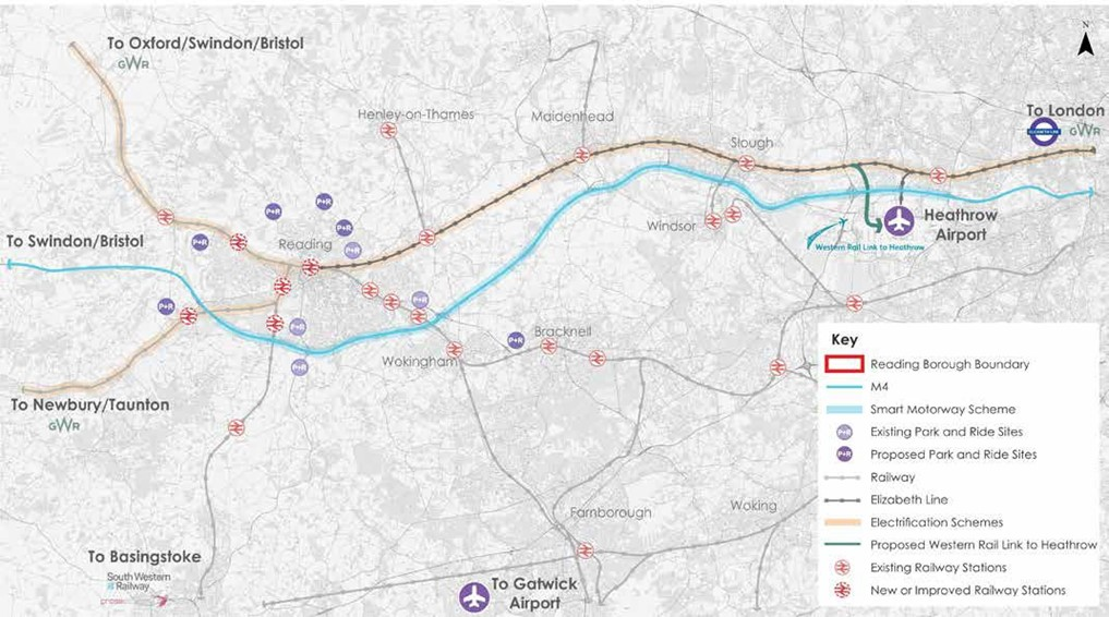
Funding and implementation
Potential funding sources
7.1 We are under increasing financial pressure, with cuts to our budget and inconsistent streams of funding available. Figure 37 shows how our transport budget has decreased by nearly 30% in real terms per resident of Reading since 2015 (84), and we expect this to continue to reduce further in future years.
7.2 Therefore, we must work hard to secure funding from other sources, to enable us to deliver the infrastructure Reading needs to support its residents, employees, visitors and economy.
7.3 We will investigate potential new and innovative funding sources, such as corporate partnerships and private investment, and also seek to reduce costs, for example through requiring statutory undertakers to deliver higher quality reinstatement works when undertaking streetworks.
7.4 Funding that does become available is often limited, and therefore we expect to deliver many of our schemes, particularly larger ones, in phases as funding becomes available. As part of the consultation and engagement process, we will set out where this is the case, and how phases of schemes and sections of infrastructure fit in to our wider future vision for transport.
Funding bids
7.5 We have an excellent track record for successfully bidding for funding from central government and obtaining funding from a range of other sources, including the Department of Transport, Thames Valley Berkshire Local Enterprise Partnership and the European Union.
7.6 Funding from successful bids has been used previously to deliver schemes such as Christchurch Bridge, South BRT, Mereoak Park and Ride, Winnersh Park and Ride, NCN Route 422, Reading West Railway station, and major upgrades to Reading Railway Station, the M4 Junction 11 and Emergency Active Travel Fund schemes.
Parking and enforcement
7.7 Our enforcement of traffic restrictions is proposed to continue, including bus lanes and parking, as set out in Chapter 6. We have seen an increase in compliance over recent years which is the objective of our enforcement, rather than for revenue generation.
7.8 We also charge for on-street pay and display parking, Council-owned car parks and resident parking permits in Reading. Revenue from parking and from penalty charge notices is ring-fenced for transport-related schemes, in accordance with the Road Traffic Regulation Act 1984, and so cannot be spent on other Council services. In previous years, we have used revenue from parking and enforcement to fund schemes such as supported bus services and discretionary concessionary fares, road safety schemes, and highway drainage improvement works.
Developer contributions
7.9 We also use developer contributions (through Section 106 obligations and the Community Infrastructure Levy) to deliver many of our schemes. Developer contributions are also used to complement other funding streams, particularly for large schemes.
7.10 Developers can be required to deliver infrastructure needed to support proposed development. We also collect developer contributions to fund new bus services for developments in their early years.
7.11 We will continue to work with developers to negotiate funding and delivery of transport infrastructure identified in this strategy that supports new developments. However, some of the schemes identified in this Local Transport Plan will require a significant level of capital funding, alongside revenue funding to help operate and maintain the new infrastructure.
Demand management
7.12 As set out in Chapter 6, we are investigating the delivery of demand management measures in Reading. Further work is being carried out to determine which measures would be most effective.
7.13 Demand Management offers the opportunity to better manage traffic growth, whilst also providing an on-going funding stream for investment in Reading. Revenue raised from demand management could allow us to accelerate the delivery of elements of this or other Council strategies, dependent upon other funding sources available at the time.
7.14 A continuous funding stream also allows us to more easily deliver transport schemes which require revenue (rather than capital) funding, such as an expanded concessionary or discounted travel scheme.
Our implementation plans
7.15 Many of the potential funding mechanisms to support delivery of our transport strategy are still evolving, and so our implementation plan will be refreshed every three years, to allow our funding plans to be updated.
7.16 Our implementation plan sets out our indicative delivery programme and mechanisms for our transport schemes. We will publish a detailed delivery programme on an annual basis, which will allow us to adapt to changing technologies, budgets and development proposals. We will also develop strategies to provide further detail and implementation strategies to support our policies.
Delivery partners
7.17 We have identified a number of key delivery partners in our implementation plan. Further information on our stakeholders and partners is detailed within the individual scheme description in Chapter 6 – Schemes and Initiatives, further information is provided in Chapter 8 – Partnerships and Stakeholders.
Working with other agencies
7.18 Other agencies such as Transport for the South East, National Highways, Network Rail, and the Department for Transport, are working on developing the case for a variety of strategic transport schemes and policies that will directly affect Reading. Some of these major schemes are included within this Transport Strategy, and within the relevant policy documents of those agencies.
7.19 We will act as a positive partner in the development of such schemes, where they align with the objectives of the RTS.
Delivery mechanisms

7.20 We will deliver our schemes through a number of mechanisms:
- Major Capital Schemes (MCS): Our major capital-funded schemes will be delivered as individual projects, and are dependent on the availability of capital funding, among other factors.
- Revenue Schemes (RS): Our revenue schemes will be delivered as on-going projects, and are dependent on the availability of revenue funding, among other factors.
- Neighbourhood Area Action Plans (NAAP): Our Neighbourhood Area Action Plans, covering the areas shown in Figure 38, will be used to deliver local interventions, working closely with local communities to develop scheme details.
Partnerships and stakeholders
Introduction
8.1 Our Strategy is ambitious, therefore working in partnership with key stakeholders is vital to its successful delivery. Transport issues are paramount for many activities, services, agencies and organisations. One of our major strengths is the interest and involvement of our local communities, businesses and other stakeholders and our commitment to consultation and consideration of their different viewpoints in all aspects of scheme design and implementation.
8.2 We actively participate in numerous formal and informal, internal and external partnerships to support a joined up approach to delivery of our key services and future plans. We will continue to engage with local residents and members of the business community when forming transport policies and strategies, and proposals are framed to take account of the diverse needs and aspirations of local stakeholders. We also receive and review communication from partners and the public on transport matters on an ongoing basis.
8.3 Partner involvement and public engagement allows us to access both expert and local knowledge, and this helps to inform our approach. We can outline specific interventions or local initiatives at an early stage of option development or scheme design to seek public contribution to help shape them.
8.4 We seek feedback during implementation and on scheme completion. It also encourages partner and local community involvement in schemes and the decision process, to build greater confidence in, and ownership of improvements in the local community.
8.5 A range of consultation techniques and methods are used. These include partnerships and various channels of communication. Innovative ways of keeping up with social change, social media and building better engagement are part of our long-term strategy.
Partnerships
8.6 Reading is at the heart of a wider economic area within the Thames Valley. It is part of a variety of partnership groups in this area, reflecting the need to work across Local Authority boundaries for different levels of service delivery, lobbying for investment and prioritising transport projects to support Reading’s role as a major hub in the Thames Valley and wider south-east region.
8.7 Embracing new technology will enable us to make the most efficient use of our limited available resources, it is important that we work positively with our strategic partners, which include neighbouring Local Authorities and Local Highway Authorities, the Thames Valley Berkshire Local Enterprise Partnership and strategic transport bodies including Transport for the South East, the Berkshire Strategic Transport Forum and the Berkshire Local Transport Body.
8.8 We also partner with other bodies, such as Reading’s Economic & Destination Agency (REDA) and the Community Safety Partnership.
8.9 Our key delivery partners include:
National/regional
- Central government including Department for Transport
- Transport for the South East
- Network Rail
- National Highways
Neighbouring local authorities
- Wokingham Borough Council
- West Berkshire Council
- Bracknell Forest Borough Council
- Hampshire County Council
- Oxfordshire County Council
- South Oxfordshire District Council
- Local Parish and Town Councils
Transport operators
- Train operators including Great Western Railway and South Western Railway
- Bus operators including Reading Buses
- Community transport operators including Readibus
- Reading taxi associations
Local community
- Community groups and local residents
- Private sector including local businesses
- Education providers including the University of Reading, colleges and schools
- Public services including the Police, Fire Service and the NHS
- Media
8.10 We will seek to work collaboratively with our partners to:
- Develop shared ideas and solutions to deliver our transport Strategy
- Widen the beneficial impacts of our schemes and policies to surrounding areas and communities
- Deliver sustainable economic growth
- Seek greater levels of funding to allow us, and our partners, to accelerate our delivery plans.
Transport for the South East
8.11 Reading Borough Council is a partner in Transport for the South East (TfSE) – a new body which brings together representatives of 16 transport authorities and five local enterprise partnerships to improve the transport network and grow the economy of the whole South East area. Its key aim is to support and grow the economy by delivering a quality, integrated transport system that makes the region more productive and competitive and improves the quality of life for all whilst protecting the environment. TfSE is already working closely with central government and is intended to become a statutory body. We will continue to work closely with TfSE in the future.
Local businesses
8.12 Reading is a key hub in the Thames Valley with a high concentration and key offices for international businesses, alongside many small and medium enterprises and startups, bringing innovation and employment opportunities across the borough and wider travel to work area. We have worked closely with local businesses to deliver many elements of our previous LTPs, and our relationship will continue to be important in the delivery of our vision for the RTS.
Berkshire Strategic Transport Forum
8.13 The Berkshire Strategic Transport Forum (BSTF) similarly brings together the six unitary authorities (including Reading Borough Council), DfT, National Highways, Network Rail, Heathrow Airport Limited, and various train and bus operating companies to discuss and consult on cross-boundary strategic transport issues. The BSTF co- ordinates transport policy across Berkshire covering a range of issues and opportunities.
Berkshire Prosperity Board
8.14 The Berkshire Prosperity Board was established in 2024 to bring together the six Berkshire local authorities to drive and deliver economic prosperity across Berkshire with the aim of securing more funding, creating more jobs and enabling more affordable housing for residents.
8.15 In particular, the Berkshire Prosperity Board will enable the councils to:
- Work to a shared vision of inclusive and sustainable economic prosperity to address challenges and deliver opportunities
- Have a strengthened case to government and private investors for greater investment into strategic projects across Berkshire
- Work with Thames Valley Berkshire Local Enterprise Partnership (LEP) to implement changes in the Government’s review of Local Enterprise Partnerships and deliver local economic priorities
- Have a stronger, collective voice in lobbying government and other agencies
- Place the six Berkshire Local Authorities in a strong position to take forward potential proposals which benefit from additional responsibilities and funding opportunities
Neighbouring authorities
8.16 Delivering our vision for transport will require effective working with neighbouring local transport authorities and local transport operators to deliver effective cross-boundary transport networks that respond to the needs of all users. Working in partnership with other organisations will help to provide better outcomes for door-to-door journeys and deliver value for money results.
8.17 We recognise the importance of ensuring maintenance, infrastructure and transport services are not affected by authority boundaries, particularly with substantial growth in neighbouring areas which will likely increase movement to, from, and through the borough. Our partnerships with neighbouring authorities are particularly important to us and the implementation of cross-boundary schemes, and we will continue to work closely with them to develop and deliver these schemes that support growth in the area, including:
- Demand management
- Key transport corridor multi-modal improvements
- Cross-Thames travel
- New and upgraded railway stations
- Bus rapid transit
- New and expanded Park and Ride mobility hubs
- Superbus network
- Concessionary travel schemes
- Strategic pedestrian routes
- Strategic and town centre cycle routes
- Cycle parking mobility hubs and facilities
- Micro-mobility hire scheme
- Intelligent transport systems – managing travel on the roads
- Smart city initiatives
- Travel information and advice
- Progress reporting and public engagement
Reading’s Economic and Destination Agency
8.18 Reading’s Economic & Destination Agency (REDA), formerly Reading UK, is a community interest company created in 2007, which operates as a private sector- led partnership with the public sector, to create opportunities and remove barriers to growth in Reading. REDA’s Economic Recovery & Renewal Strategy 2021-2024 has been developed to support economic recovery following the Covid-19 pandemic, and also to address the inherent challenges in the local economy that existed prior to the pandemic, and to continue to deliver the Reading 2050 vision. We will continue to work closely with Reading UK to deliver our vision for transport in line with the wider Reading 2050 vision and to support economic growth in Reading.
Other partners
8.19 There may be opportunities to partner with other organisations to design and deliver schemes, such as Sport England, the Canal and River Trust, and Sustrans. We will embrace partnership working to enable us to deliver our vision for transport.
Community Safety Partnership
8.20 No one agency can tackle crime, or fear of crime, by working alone, particularly in the current economic climate. In Reading, we believe that crime, disorder, anti-social behaviour and the fear of crime can only be tackled through partnership working.
8.21 The Community Safety Partnership comprises of statutory agencies, including Reading Borough Council, Thames Valley Police, the National Probation Service, the Community Rehabilitation Company, Royal Berkshire Fire and Rescue Service and Public Health. These agencies have joined forces to tackle crime, anti-social behaviour and the fear of crime, and are committed to supporting and working alongside our communities in reducing the impact of crime and disorder that concern them locally, including transport issues.
Forums
8.22 Various information and consultation forums have been set up for members of the public and transport-user groups, to facilitate engagement and discussion around a number of topics. Forums particularly relevant to the delivery of the RTS include those opposite.
8.23 We will continue to engage and consult with these forums to deliver the RTS and vision for Reading.
- The Cleaner Air & Safer Transport Forum, made up of local interest groups and key partners, influences and facilitates the development of the Council’s sustainability agenda, including climate change, transport and air quality.
- The Reading Climate Change Partnership, is a network of people and organisations that are actively trying to improve our town’s response to climate change, and the challenges this brings.
- The Mid and West Berkshire Local Access Forum, which comprises membership from Reading, Wokingham and West Berkshire unitary authorities, local landowners and user groups, and has been instrumental in the preparation and delivery of our Rights of Way Improvement Plan.
- The Access and Disabilities Working Group, which facilitates discussion on improving accessibility in Reading, ensuring that the needs of disabled transport users are considered through the RTS and delivery.
- The Older People’s Working Group, which identifies and promotes awareness of issued facing older residents and provides a channel for older people to influence the development of local services, including transport.
Policy committee
The cross-party committee oversees the overall direction of the Council’s strategy, policy and budget, including economic development and regeneration.
Strategic Environment, Planning and Transport Committee
The cross-party committee is responsible for statutory and non-statutory functions relating to Environment, Planning, Highways and Transport.
Traffic Management Sub-Committee
The sub-committee acts as a consultative body to promoting public transport, walking and cycling within Reading.
Reading Area Transport Strategy Delivery Group
Led by RBC and attended by representatives from all key stakeholders including neighbouring local authorities.
Monitoring and review
Introduction
9.1 Performance monitoring is key to ensuring the successful delivery of this strategy and monitoring progress against our objectives. We will undertake monitoring and surveying, and collect data to support this, to inform our evolving transport programme and keep it under review.
Data collection
9.2 We will collect a wide range of data to support us in developing our schemes and initiatives to best deliver our vision. This will include maintaining a network of multi- modal data collection sites such as traffic surveys, parking surveys, pedestrian and cycle counts, and the annual town centre monitoring surveys. We will do so by making use of new and evolving technology.
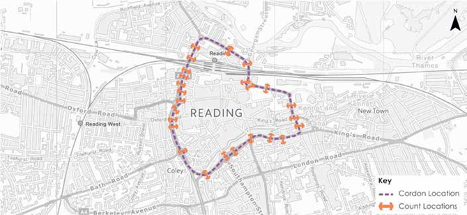
Performance indicators
9.3 We have identified a number of key performance indicators and targets against which we will monitor our progress which are set out in the following tables.
9.4 Progress towards our targets and delivering our vision for transport in Reading will vary year on year, depending on when individual schemes are delivered. We have therefore set overall targets for the RTS to achieve by 2040.
9.5 We will monitor our progress on an annual basis against these targets, recognising that a linear path of progress is not necessarily anticipated, as each target will be influenced by a variety of transport and external factors.
Reviewing out strategy
9.6 Given the longer-term time scales for this Strategy, it will be regularly reviewed to ensure it remains current and that it is best placed to respond to future needs and opportunities as they arise.
9.7 Our strategy has been developed in partnership with local residents, businesses and stakeholders through extensive consultations undertaken during 2019 and 2020. It is underpinned by statutory assessments relating to the environment, health and equality to ensure the impacts of the plan provide positive benefits and meet relevant legislation in these key areas.
9.8 Challenges and opportunities have been identified based on robust data and adopted policy, with priorities and policy approaches identified to deal these challenges and embrace opportunities as they arise.
9.9 Further engagement and analysis will be undertaken as individual schemes and initiatives are developed. We will work with a range of partners and technical and academic research groups in order to support the robust technical work of developing, testing and validating options, particularly on innovative projects.
9.10 As elements of the Strategy are delivered, we will monitor, benchmark and measure the results to monitor progress, and influence the methodology by which future actions are prioritised and approved.
9.11 This approach allows the Reading Transport Strategy 2040 to be continuously reviewed and updated to ensure the overall vision and objectives of the Strategy are delivered.
Glossary
Artificial intelligence
The capability of a machine to imitate intelligent human behaviour, like visual perception, speech recognition and decision making
Autonomous vehicles
Vehicles that can operate without a driver
Big data
Extremely large datasets that can be analysed to reveal patterns and trends
Biodiversity
The variety of all living things, including plants, animals and habitats, and their interactions together within a particular area
Bus Rapid Transit (BRT)
Public transport that uses dedicated lanes and routes, and so is separated from general traffic, and has limited numbers of stops so it is a faster service serving key destinations
Carbon emissions
The release of carbon dioxide (CO2) and other greenhouse gases (CO2 equivalent) into the atmosphere
Carbon neutral
Achieving an overall balance between Greenhouse Gases (GHG) produced and GHG taken out of the atmosphere
Connected autonomous vehicles
Vehicles that are both connected and autonomous
Connected vehicles
Vehicles that can talk to both each other and the infrastructure around them (for example traffic lights)
Decarbonisation
The reduction or removal of CO2 emissions from a product or process
Digital twin
A digital model of a town, which includes networks such as transport and power, and historical and real-time data.
GVA
A measure of the value of goods and services produced in an area, industry or sector of the economy
IDR (Inner Distribution Road)
The ring road that surrounds Reading town centre, which comprises Vastern Road, Forbury Road, part of the A329 and Caversham Road
Interchange
The action of switching between transport modes or services, or a place where this happens (such as a railway station)
Internet of Things
A network of all devices that are connected to the internet, for example computers, phones, as well as things like some traffic lights, cars, washing machines and fridges
Local Cycling and Walking Infrastructure Plan (LCWIP)
A sub-strategy to the Local Transport Plan, setting out our vision and strategy for walking and cycling in the borough.
Local Transport Plan
A statutory document setting out the objectives, policies and schemes intended to improve transport in an area. The Reading Transport Strategy is Reading’s Local Transport Plan to 2040.
Machine learning
Where a computer programme can access data and use it to learn for themselves, rather than being explicitly programmed by a person
Mobility as a Service (MaaS)
This is a digital transport service platform, accessed by web or mobile app, that enables users to plan, access, pay for and get real time information, on a range of public and private transport options.
MaaS is seen as a way to reduce individual car ownership, and replace it with mobility services that meet user’s needs.
Mobility Hub
these bring together shared transport with public transport and active travel in well-designed public spaces. They can be large, such as around a railway station, or smaller, embedded in communities, providing sustainable alternatives to private car ownership for travel.
Mode
The method of travel, such as walking or by bus
Mode shift
A change in the mode of transport
Natural surveillance
Where something is naturally visible by other people, for example from passing traffic or nearby homes
Orbital movements and routes
A movement or route that is around Reading, rather than to, from or across the town centre
Particulate pollution
A mixture of tiny solid and liquid droplets that float in the air
Pinch point
A part of the public highway where congestion is particularly likely to occur (whether vehicle congestion or congestion of pedestrians, cyclists or public transport)
Public Right of Way
A path that anyone has the legal right to use on foot, and sometimes using other modes of transport
Quality of life
The conditions in which we live, including social factors such as environment and physical and mental health, as well as material and economic factors
Real-time data
Data that is delivered immediately after collection
Shared autonomous vehicle
An autonomous vehicle that can carry many people and operates as a public transport service
Sustainability
Meeting the needs of the present, without compromising the ability of future generations to meet their needs
Traffic Regulation Orders
A legal tool which allows local authorities (like us) to restrict, regulate or prevent the use of any public road, or right of way
Wayfinding
The process of working out where you are, how to get to where you want to be and following the route accordingly
References
- National Infrastructure and Construction Pipeline – KPMG Analysis 2018
- Infrastructure and Projects Authority, Analysis of the National Infrastructure and Construction Pipeline 2021
- Office for National Statistics, Table 2: 2016-based sub-national population projections for local authorities and higher administrative areas in England
- Office for National Statistics, Table 2: 2018-based sub-national population projections for local authorities and higher administrative
- Office for National Statistics, Population Estimates Mid-2029 Table MYE5
- Office for National Statistics, LI01 Regional labour market: Local indicators for counties, local and unitary authorities, July 2021 to June 2022
- Nomis, Labour Market Profile – Reading, https://www.nomisweb.co.uk/ reports/lmp/la/1946157285/report. aspx?town=Reading#tabempunemp
- Centre for Cities, https://www. centreforcities.org/city/reading/, 2020
- Thames Valley Berkshire Local Skills Report, TVB, 2022
- GlobalData Consulting Top 50 UK Shopping Centres, October 2018
- Centre for Cities, https://www. centreforcities.org/city/reading/, 2021
- Centre for Cities, https://www. centreforcities.org/city/reading/, 2021
- Thames Valley Berkshire Impact Report 2019-2020 https://www.thamesvalleyberkshire. co.uk/2020-impact-report/
- Centre for Cities, https://www. centreforcities.org/city/reading/, 2016
- Ministry of Housing, Communities & Local Government, English Indices of Deprivation 2010, English Indices of Deprivation: Overall
- Ministry of Housing, Communities & Local Government, English Indices of Deprivation 2015, File 1: Index of Multiple Deprivation
- Ministry of Housing, Communities & Local Government, English Indices of Deprivation 2019, File 1: Index of Multiple Deprivation
- EY, UK Regional Economic Forecast – News Release January 2022
- Office for National Statistics, 2011 Census Table WD1101EW
- Department for Transport Statistics, Road Congestion Statistics Table CGN0504d, 2021
- EY, UK Attractiveness Survey 2019
- Centre for Cities, https://www. centreforcities.org/city/reading/, 2019
- PwC, Good Growth for Cities 2022
- GL Hearn, OAN Sensitivity Testing – Western Berkshire Housing Market Area, March 2018 (assuming 5000 homes of West Berkshire’s need are delivered within the city region)
- Public Health England, Spatial Planning for Health: An evidence resource for planning and designing healthier places, June 2017
- Public Health England, Spatial Planning for Health: An evidence resource for planning and designing healthier places, June 2017
- Chartered Institute for Highways & Transportation, ‘Better Planning, better transport, better places’, August 2019
- Journal of Environmental Planning and Management. Pretty, J. Peacock, J. Hine, R. Sellens, M. South, N & Griffin, M. (2007) Green Exercise In The UK Countryside: Effects On Health And Psychological Well-Being, and Implications For Policy And Planning
- The NHS Information Centre for health and social care. McManus, S, Bebbington P, Jenkins R, Brugha T. (eds.) (2016). Mental health and wellbeing in England: Adult Psychiatric Morbidity Survey 2014. Leeds: NHS Digital
- Public Health England, Spatial Planning for Health: An evidence resource for planning and designing healthier places, June 2017
- Office of Rail and Road Estimates of Station Usage 2020-21, November 2022
- Society of Motor Manufacturers & Traders https://www.smmt.co.uk/2018/08/feature-how- apps-are-transforming-bus-travel/
- Reading Buses https://www.reading-buses. co.uk/about-us
- Reading Buses, Fleet List January 2022, https://images.reading-buses.co.uk/downloads/ Fleet%20List%202022-01.pdf
- Department for Transport Statistics, Bus Statistics Table BUS01f, January 2023
- Office for National Statistics, Regional Gross Value Added (Balanced) by Industry: City and Enterprise Regions, Table B3 Enterprise Regions Current Price Estimates, May 2022
- Office for National Statistics, Subregional Productivity Labour Productivity Indices by Economic Enterprise Region, Table A3 GVA (B) per hour worked, July 2022
- Department for Transport Statistics, Road Congestion Statistics Table CGN0504d, 2021
- Office for National Statistics, Labour Force Survey, https://www.ons. gov.uk/employmentandlabourmarket/ peopleinwork/labourproductivity/adhocs/008005traveltoworkmethodsandthe timeittakestocommutefromworklabourforce survey2007to2016
- Reading Council, Transforming Cities Fund Bid, http://www.reading. gov.uk/media/8934/ Central-Berkshire- Growth-City-Region— Transforming- Cities-Fund-Application-Form/pdf/ Central_Berkshire_Growth_City_Region_-_Transforming_Cities_Fund_Application_form_ only. pdf
- Network Rail, https://www. networkrailconsulting.com/our-capabilities/ network-rail-projects/reading-station-area- redevelopment/
- http://news.reading.gov.uk/red- route-goes-live
- Department for Environment, Food & Rural Affairs, UK Climate Change Risk Assessment 2022
- Department for Transport, Transport and Environment Statistics 2022
- https://www.iea.org/commentaries/ growing-preference-for-suvs-challenges-emissions- reductions-in-passenger-car-market
- https://www2.deloitte.com/uk/en/pages/ press-releases/articles/21-million-more-electric- vehicles-expected-worldwide-by-2030.html
- Klaus Schwab, The Fourth Industrial Revolution, 2016
- Department for Transport, Taking Flight: The Future of Drones in the UK, 2018
- PwC, Skies Without Limits, 2018
- https://www.racfoundation.org/media- centre/cars-parked-23-hours-a-day
- Public Health England, Associations of long- term average concentrations of nitrogen dioxide with mortality, 2018
- B Miller & F Hurley, Comparing estimated risks for air pollution with risks for other health effects, Institute of Occupational Medicine, Report TM/06/01, 2006
- Public Health England, Public Health England, Estimating Local Mortality Burdens associated with Particulate Air Pollution, 2014
- Public Health England, Public Health Profiles, Indicator 40701 Under 75 mortality rate from respiratory disease (Persons, 3 year range) – Reading, 2017-19
- V Timmers & P Achten, Non-exhaust PM emissions from electric vehicles, Atmospheric Environment 134 (2016) 10-17
- Department for Transport Statistics, Bus Statistics Table BUS01e, January 2023
- Office for National Statistics, 2011Census Table WU02EW
- Reading Transport Model, 2015 Baseline AM Peak. Proportion of modelled traffic using IDR that does not have an origin or destination in Reading town centre and could route via alternative roads, either currently, or if new/improved orbital links were available as set out within this strategy
- Office for National Statistics, 2011Census Table WU02EW
- Department for Transport Statistics, Bus Statistics Table BUS0109a, 2021
- Ministry of Housing, Communities & Local Government, English Indices of Deprivation 2019
- Ministry of Housing, Communities & Local Government, English Indices of Deprivation 2019
- Ministry of Housing, Communities & Local Government, English Indices of Deprivation 2019
- Office for National Statistics, 2011 Census Table QS303EW
- Office for National Statistics, 2011 Census Table QS103EW
- Office for National Statistics, 2011 Census Table LC1109EW
- Office for National Statistics, 2011 Census Table KS102EW
- Department for Transport, National Travel Survey Table NTS0201
- Office for National Statistics, 2011 Census Table LC3407EW
- Department for Work and Pensions, Economic Labour Market Status of Individuals Aged 50 and Over, Trends Over Time, September 2022
- Office for National Statistics, Table 2: 2018-based subnational population projections for local authorities and higher administrative areas in England
- Office for National Statistics, Population of the United Kingdom by country of birth, July 2020 to June 2021, Table 1.1
- Office for National Statistics, Median age of population for local authorities in the UK mid-2020, Table MYE6
- Department for Transport, National Travel Survey Table NTS0503, 2021
- NHS National Child Measurement Programme, Table 2_6, 2021/22 (school year)
- Department for Transport, National Travel Survey Table NTSQ03004A
- Reading Council, Transforming Cities Fund Bid, http://www.reading.gov.uk/media/8934/ Central-Berkshire-Growth-City-Region— Transforming-Cities-Fund-Application-Form/ pdf/Central_Berkshire_Growth_City_Region_-_ Transforming_Cities_Fund_Application_form_only. pdf
- Reading Borough Council Local Plan, November 2019
- EY, UK Regional Economic Forecast – News Release January 2022
- Department for Transport, Road Safety Statistics, STATS19, 2001 to 2021
- Department for Transport, Road Traffic Statistics Manual Count Points Site Number 99740, AADF 2021
- Department for Transport, National Travel Survey Table NTSQ03004A
- Play England, Why Temporary Street Closures for Play Make Sense for Public Hea
Last updated on 22/04/2025
Reading Transport Strategy 2040 – published June 2024