Public Rights of Way
Public Rights of Way are rights across land accessible by the public, which allow people to pass along them– even if the land is privately owned.
These include:
- footpaths – can be used for walking, running, mobility scooters or powered wheelchairs;
- bridleways – which can be used for walking, horse riding, bicycles, mobility scooters or powered wheelchairs;
- restricted byways (for any transport without a motor – except for powered wheelchairs or mobility scooters);
- and byways which are open to all traffic including cars (but they’re mainly used by walkers, cyclists and horse riders).
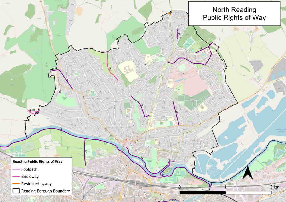
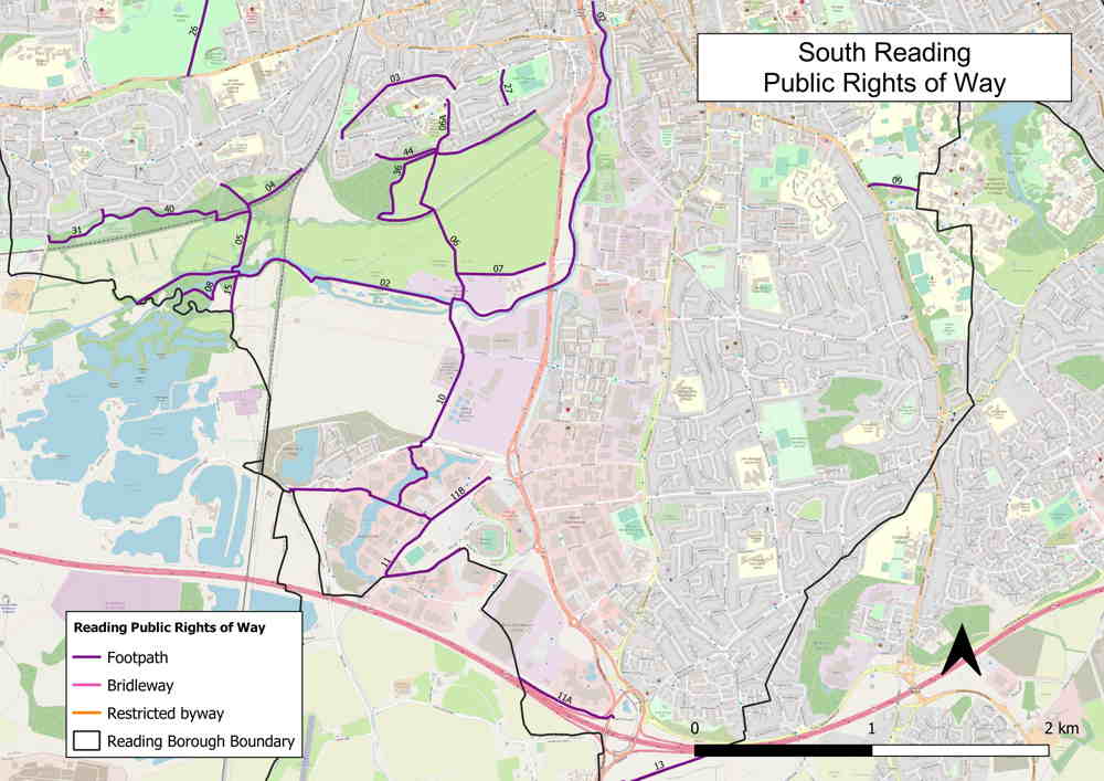
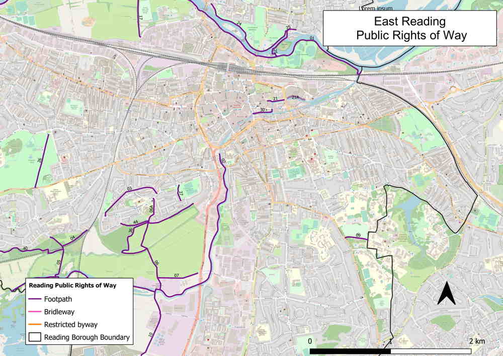
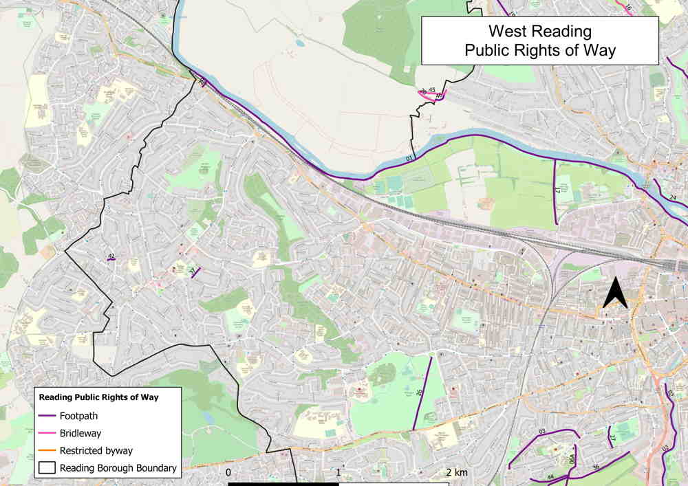
The Council manages 21 miles of Public Rights of Way across the borough, 41 footpaths, three bridleways and one restricted byway.
Where are the Public Rights of Way in Reading and how are they used?
The Public Rights of Way in Reading can be seen in the following maps: North, South, East and West Reading.
These paths are vital connections for many people to access open space and are often used by residents when travelling to work and school as well as rural-type routes that are used for leisure purposes.
Some of these are key routes connecting people to key destinations, such as the town centre, Reading Station, Green Park and Thames Valley Business Park. Other routes provide nice walks in nature for the public and continue into neighbouring councils. Trails in Reading include:
- The Thames Path National Trail crosses through Reading – Thames Path National Trails
- Thames Path – Reading to Henley-on-Thames
- River Kennet – Walk River Kennet from Town Centre
How and where are the Public Rights of Way recorded?
All the Public Rights of Way are listed and described in the Definitive Map accompanied by the Definitive Statement. Both are held and updated by Reading Borough Council. They provide the conclusive evidence that the Public Rights of Way shown upon them legally exists.
- The Definitive Map – is a map prepared by a surveying authority which is a legal record of the Public’s Rights of Way. The Definitive Statement –is the statement that accompanies the Definitive Map and includes descriptions of every path indicated on the Map, including legal restrictions, widths and other information.
- Digital map – go to My Maps, select Boundaries – Public Rights of Way
For any further enquiries please contact the transport team.
Planning your journey using the Public Rights of Way
The Public Rights of Way in Reading are not a standalone network of paths. In an urban environment such as Reading, they form part of the larger network of walking and cycling – all linking to key destinations and nature. They also form part of a national trail leading into other local authorities.
In this interactive map you can:
- view the Public Rights of Way as a standalone network
- combine the Rights of Ways network with the walking or cycle networks and key locations
- interact with all paths/routes/locations on the map to find further information.
This is an evolving map.
The National Footpath Map allows you to plan your journey on the public rights of way into neighbouring councils ( e.g. Wokingham and West Berkshire) and join national trails that cross through Reading.
These two interactive maps are not the definitive map and are not a legal record of the rights of way. For the definitive map or statement please contact Transport@reading.gov.uk
How did Public Rights of Way become established?
There are four ways to establish a Public Right of Way:
- Compulsory Path Order – The local authority makes an order to create a footpath or bridleway over land in their area where they think it would add to the public’s convenience or enjoyment. There is a period set for objection by the land owner/ public.
- Creation Agreements – The local authority enters into agreements with landowners to create footpaths, bridleways or restricted byways. The agreement is drawn up and signed by the two parties.
- Express Dedication – A landowner may expressly dedicate a right of way over his or her land, but this is rare. Then no agreement is required.
- Presumed Dedication – Most Public Rights of Way have come into existence by presumed dedication – this refers to a long-established principle that long use by the public without challenge can constitute evidence that the landowner intended to dedicate the used route as a public right of way.
What processes are available to make changes to the Public Rights of Way?
There are two major legal processes available to the public and the Council to make changes to the definitive map and statement.
- Definitive Map Modification Orders (DMMO) – These orders are about getting a right of way recorded or modified on a Definitive Map. This is about rights that should exist but not recorded as public rights or not recorded correctly. The application is based on evidence of regular usage of the path and presumed dedication by the landowner, or historical document evidence demonstrating it was used once as a public path.
- Public Path Order (PPO) – These orders are about the creation of new Public Rights of Way or closure, or diversion of an existing path. There are many reasons for applying for a Public Path Order. A path may be created based on the benefits to the public or the need for access, a path may be closed or diverted due to nuisance caused by the public, development requirements, safety and maintenance requirements and many more.
Find out more about the process of applying for a Definitive Map Modification Order or Public Path Order using the following guidance A guide to definitive maps and changes to public rights of way.
For further information on how to apply please contact: Transport@reading.gov.uk
Reporting a problem on one of the Public Rights of Way
If there is a maintenance requirement or an incident on one of the paths please report this issue online.
Rights of Way Improvement Plan (ROWIP)
Find information on Reading’s Rights of Way Improvement Plan here.
Last updated on 05/03/2026
Public Rights of Way